

São João (Lajes do Pico)
Encyclopedia
São João, named for the John the Baptist
(in Portuguese
) is a civil parish in the municipality of Lajes do Pico
in the Azores
. It is the only parish in the municipality with a frontier on the summit of Pico (2,351 meters). The population in 2001 was 486, its density is 15/km² and the area is 32.31 km²; making it the third least-populated parish in the municipality.
 The village of Sao Joao is located on the main roadway (Estrada Regional E.R.1-1ª) between hamlets of Terra do Pao (São Caetano
) and Silveira (Lajes do Pico). São João comprises two distinct communities, the upper (Companhia de Cima) and lower (Companhia de Baixo) portions of the village.
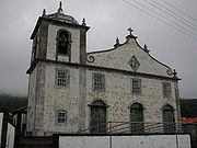
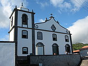
The single-bell tower parochial church is in the lower district in close proximity to the small sea port. It was extensively renovated following historical earthquakes, with a tiled front-facade constructed over quarried rock. A secondary chapel was constructed within the past decades to support the upper congregation in a modernist style. A park was also constructed around the lava flows that destroyed the original church (in 1720).
The village of Sao Joao is a quiet community that includes a cafe/mercantile shop, restaurants, an auto repair garage (ironically in the location of the former village blacksmith's shop), and a commercial cheese factory. Being primarily agricultural community now (as whaling was discontinued in the 1970s), most of the grassing lands are located in the mid-altitudes, as dense vegetation dominate the top of the mountainous Achada Plain and Pico Volcano. Other landmarks include a small chapel used for the Holy Spirit feasts, in each of the upper and lower villages, and village squares constructed (such as the Largo de São João) to provide picnicking facilities, playgrounds and animal pens. Along the seashore, Ponte de São João provides a sand volleyball court, showers and picnic facilities adjacent to a point projecting out in the ocean, with small tidal pools and natural swimming area.
John the Baptist
John the Baptist was an itinerant preacher and a major religious figure mentioned in the Canonical gospels. He is described in the Gospel of Luke as a relative of Jesus, who led a movement of baptism at the Jordan River...
(in Portuguese
Portuguese language
Portuguese is a Romance language that arose in the medieval Kingdom of Galicia, nowadays Galicia and Northern Portugal. The southern part of the Kingdom of Galicia became independent as the County of Portugal in 1095...
) is a civil parish in the municipality of Lajes do Pico
Lajes do Pico
Lajes do Pico is a municipality in the southern part of the Azores.The municipality is located is on the southern part of the Pico Island. The northern area of the municipality is mountainous while the Atlantic Ocean is in the south. The only road linking to the northern part of the island runs...
in the Azores
Azores
The Archipelago of the Azores is composed of nine volcanic islands situated in the middle of the North Atlantic Ocean, and is located about west from Lisbon and about east from the east coast of North America. The islands, and their economic exclusion zone, form the Autonomous Region of the...
. It is the only parish in the municipality with a frontier on the summit of Pico (2,351 meters). The population in 2001 was 486, its density is 15/km² and the area is 32.31 km²; making it the third least-populated parish in the municipality.
Geography
São Caetano (Madalena)
São Caetano is a civil parish in the municipality of Madalena along the southwestern coast of the island of Pico, the Portuguese Azores. It occupies an area of 24.36 km², with approximately 550 inhabitants as of 2001 .-Geography:The parish is located in the southern part of the municipality...
) and Silveira (Lajes do Pico). São João comprises two distinct communities, the upper (Companhia de Cima) and lower (Companhia de Baixo) portions of the village.
The single-bell tower parochial church is in the lower district in close proximity to the small sea port. It was extensively renovated following historical earthquakes, with a tiled front-facade constructed over quarried rock. A secondary chapel was constructed within the past decades to support the upper congregation in a modernist style. A park was also constructed around the lava flows that destroyed the original church (in 1720).
The village of Sao Joao is a quiet community that includes a cafe/mercantile shop, restaurants, an auto repair garage (ironically in the location of the former village blacksmith's shop), and a commercial cheese factory. Being primarily agricultural community now (as whaling was discontinued in the 1970s), most of the grassing lands are located in the mid-altitudes, as dense vegetation dominate the top of the mountainous Achada Plain and Pico Volcano. Other landmarks include a small chapel used for the Holy Spirit feasts, in each of the upper and lower villages, and village squares constructed (such as the Largo de São João) to provide picnicking facilities, playgrounds and animal pens. Along the seashore, Ponte de São João provides a sand volleyball court, showers and picnic facilities adjacent to a point projecting out in the ocean, with small tidal pools and natural swimming area.