

Sydney Road, Melbourne
Encyclopedia
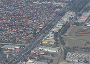
Sydney Road  is a major urban arterial in the northern suburbs of Melbourne, Victoria, Australia
.
and Brunswick
and continues north through Brunswick
, Coburg
, Coburg North
, Hadfield
, Fawkner
, Campbellfield
, Somerton
and Craigieburn
, where it joins the Hume Freeway.
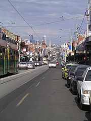
The section passing through Brunswick and Coburg, between Park Street at its southern end and Bell Street near the site of the former Pentridge prison, at its northern end, is Melbourne's longest continuous shopping strip, with an abundance of small businesses and a variety of restaurants and coffee shops, clothing stores, places of worship, and community services. It is well-known for its wedding fashion shops, discount shopping and a number of specialist food stores.
runs along the inner section of Sydney Road, starting at Bakers Road in Coburg North and ending in Elizabeth Street
at Flinders Street Station
in the city. The Upfield railway line from the city loop runs parallel to Sydney Road about 200m to the west, with stations at Jewell, Brunswick
, Anstey, Moreland and Coburg giving easy pedestrian access. Several east-west bus routes cross Sydney Road at various points (routes , , , , , , and ). The road has historically been signed as , but since the opening of the Craigieburn Bypass has been relegated to .
 The Victorian gold rush
in the 1850s caused businesses to flourish on Sydney Road. Many were established to supply the miners on their trek north to the gold fields. Numerous hotels were built along Sydney Road in this period including the Brunswick Hotel, the Cornish Arms Hotel, the Sarah Sands Hotel, the Cumberland Arms Hotel and the Court House Hotel. It was originally called Pentridge Road, as it connected the city with Pentridge prison. It was renamed Sydney Road In 1859.
The early hub of business activity was between Weston Street and Albert Street in Brunswick, but by the 1880s businesses were rapidly being established beyond Albion Street. In the 1920s the clothing and textile industries grew; evidence of their presence in the area can still be seen in the existence of tailors shops, fabric shops and an abundance of wedding gown shops.
During the 1930s the Unemployed Workers Movement held street meetings on the corner of Sydney Road and Phoenix Street. These meetings were harassed and suppressed by the police, under the direct orders of Police Commissioner, General Thomas Blamey
. Young Australian artist Noel Counihan
played a significant part in this campaign. The State Government, concerned about the public sympathy being generated, eventually changed the law in regard to obstruction, with no requirement of permits to speak. A Free Speech memorial was built outside the Mechanics' Institute on the corner of Sydney and Glenlyon Roads to commemorate the success of the free speech fights. Counihan's work as an artist and local resident is also commemorated by the Counihan Gallery on Sydney Road run by the City of Moreland
Council.
During the second world war and in the 1950s, Sydney Road came alive with late night shopping. This included late night shopping parades with floats. The construction of the Barkly Square shopping complex immediately to the east of Sydney Road in the 1980s coincided with a decline in the success of the strip. The Sydney Road Brunswick Association was formed in the early 1990s to provide a focus for action to revive the strip, utilising a range of community development and marketing techniques.
With postwar immigration, many migrant families established businesses. The multicultural nature of business on Sydney Road is reflected in the cuisines offered by its restaurants and cafes. Italian, Greek and Balkan cuisines were once the dominant non-Anglo fare, but since the 1980s Sydney Road's eateries have diversified and increased in number, so that the food available now includes Lebanese, Afghan, Thai, Chinese, Vietnamese, Japanese, North and East African, Balinese, Indian, Pakistani, Sri Lankan and Nepali cuisines. In the early 2000s, several hotels (pubs) were renovated and have become very popular live music venues. Property prices in Brunswick and Coburg (south of Bell Street) rose sharply in the 1990s and early 2000s. The signs of gentrification
are increasingly evident in the southern quarter of Sydney Road, with a rising number of clothing boutiques and many new eateries serving eclectic and contemporary Australian 'fusion' cuisine in stylish, designer environments, producing an increasingly diversified street life.
As a major activity centre
in Moreland, Sydney Road is a key component in any strategies of urban intensification to meet the requirements of the Victorian Government's metropolitan strategy, Melbourne 2030
. In his first speech in December 2006, newly elected Moreland Mayor Mark O'Brien proposed turning the entire 4.5km commercial strip between Brunswick Road and Bell Street into a promenade, which would transform the usually congested Sydney Road into one of the longest pedestrian streets in the world.
Brunswick Town Hall, built in 1876 on the corner of Dawson Street, is an imposing Victorian edifice. It was saved from planned destruction by the municipal council in 1973-1974 when Vic and Vida Little, along with the Brunswick Progress Association
, led a successful campaign to preserve it. The building was significantly extended and renovated in the early 1990s to upgrade the library, offices and public assembly spaces.
Diagonally opposite from the Town Hall stands the Mechanics Institute, built in 1868, and used for worker education and social activities. A monument to the Free Speech fights of the 1930s stands near the corner. The history of many of the single and double story shop fronts can be seen in the names and years moulded into the upper portions of the building facades. The Mechanics Institute now provides a popular performance space and offices for local arts administrators.
Each year the City of Moreland
Council organises the Sydney Road Street Party
, usually on a Sunday at the end of February, running from midday to 7pm. Sydney Road is closed to traffic from Union Street to Victoria Street in Brunswick. The Street Party launches the annual Brunswick Music Festival.
Several stages are erected for a variety of ethnic, folk and rock music to be performed live. Hundreds of community groups and local businesses set up stalls on the road. Street theatre and kids shows, and a wide variety of tasty food from many cuisines is there to be sampled. Tens of thousands of people enjoy a day of festivities taking over Sydney Road.
On 28 May 2006 Australia's first ever Cyclovia
was held on Sydney Road. From 8am–2pm the road was closed to motorised vehicles (except trams) between Brunswick Road and Bell Street, leaving the roadway free to be used by cyclists.
A second Cyclovia had been planned for Sunday, 17 February 2008, to tie in with a closure of Royal Parade and Swanston Street
as part of the Sustainable Living Festival
.However, the event was criticised by the RACV which claimed it was "a nuisance". The event was re-scheduled and took place on Sunday, 13 April 2008. Cafés along Sydney Road reported a brisk trade during the Cyclovia, while some other businesses complained they had fewer customers. Moreland
councillor
Mark Higginbotham called for the event to be held more often.
is a major urban arterial in the northern suburbs of Melbourne, Victoria, AustraliaAustralia
Australia , officially the Commonwealth of Australia, is a country in the Southern Hemisphere comprising the mainland of the Australian continent, the island of Tasmania, and numerous smaller islands in the Indian and Pacific Oceans. It is the world's sixth-largest country by total area...
.
Geography
Sydney Road starts at the northern end of Royal Parade at the boundary of ParkvilleParkville, Victoria
Parkville is an inner city suburb in Melbourne, Victoria, Australia, 3 km north from Melbourne's central business district. Its Local Government Area is the City of Melbourne. At the 2006 Census, the population was 4,980....
and Brunswick
Brunswick, Victoria
Brunswick is a suburb in Melbourne, Victoria, Australia, 6 km north from Melbourne's central business district. Its Local Government Area is the City of Moreland...
and continues north through Brunswick
Brunswick, Victoria
Brunswick is a suburb in Melbourne, Victoria, Australia, 6 km north from Melbourne's central business district. Its Local Government Area is the City of Moreland...
, Coburg
Coburg, Victoria
Coburg is a suburb in Melbourne, Victoria, Australia, 8 km north from Melbourne's central business district. Its Local Government Area is the City of Moreland, although a handful of properties on Coburg's Eastern boundary are located in the City of Darebin...
, Coburg North
Coburg North, Victoria
Coburg North is a suburb in Melbourne, Victoria, Australia, 10 km north from Melbourne's central business district. Its Local Government Area is the City of Moreland. At the 2006 Census, Coburg North had a population of 6064....
, Hadfield
Hadfield, Victoria
Hadfield is a suburb in Melbourne, Victoria, Australia, 13 km north from Melbourne's central business district. Its Local Government Area is the City of Moreland. At the 2006 Census, Hadfield had a population of 5151....
, Fawkner
Fawkner, Victoria
Fawkner is a suburb in Melbourne, Victoria, Australia, 12 km north from Melbourne's central business district. Its Local Government Area is the City of Moreland...
, Campbellfield
Campbellfield, Victoria
Campbellfield is a suburb in Melbourne, Victoria, Australia, 16 km north from Melbourne's central business district. Its Local Government Area is the City of Hume. At the 2006 Census, Campbellfield had a population of 5,401.-History:...
, Somerton
Somerton, Victoria
Somerton is a suburb in Melbourne, Victoria, Australia, 21 km north from Melbourne's central business district. Its Local Government Area is the City of Hume....
and Craigieburn
Craigieburn, Victoria
Craigieburn is a suburb in Melbourne, Victoria, Australia, 26 km north from Melbourne's central business district. Its Local Government Area is the City of Hume. At the 2006 Census, Craigieburn had a population of 20,784....
, where it joins the Hume Freeway.
The section passing through Brunswick and Coburg, between Park Street at its southern end and Bell Street near the site of the former Pentridge prison, at its northern end, is Melbourne's longest continuous shopping strip, with an abundance of small businesses and a variety of restaurants and coffee shops, clothing stores, places of worship, and community services. It is well-known for its wedding fashion shops, discount shopping and a number of specialist food stores.
Transport
Tram route 19Melbourne tram route 19
Tram route 19 is a public transport service in Melbourne, Victoria, Australia. It runs from Flinders Street in the city centre to North Coburg in the northern suburbs. It runs through the suburbs of Melbourne, Parkville, Brunswick, Coburg, and Coburg North...
runs along the inner section of Sydney Road, starting at Bakers Road in Coburg North and ending in Elizabeth Street
Elizabeth Street, Melbourne
Elizabeth Street is one of the main north-south streets in the central business district of Melbourne, Australia, part of the Hoddle Grid laid out in 1837.- Geography :...
at Flinders Street Station
Flinders Street Station
Flinders Street Station is the central railway station of the suburban railway network of Melbourne, Victoria, Australia. It is on the corner of Flinders and Swanston Streets next to the Yarra River in the heart of the city, stretching from Swanston Street to Queen Street and covering two city...
in the city. The Upfield railway line from the city loop runs parallel to Sydney Road about 200m to the west, with stations at Jewell, Brunswick
Brunswick railway station, Melbourne
Brunswick is a railway station in Melbourne, Victoria, Australia, located in the suburb of Brunswick, on the Upfield railway line. Brunswick is unmanned and is in Metcard Zone 1.-Facilities:...
, Anstey, Moreland and Coburg giving easy pedestrian access. Several east-west bus routes cross Sydney Road at various points (routes , , , , , , and ). The road has historically been signed as
, but since the opening of the Craigieburn Bypass has been relegated to .History
Victorian gold rush
The Victorian gold rush was a period in the history of Victoria, Australia approximately between 1851 and the late 1860s. In 10 years the Australian population nearly tripled.- Overview :During this era Victoria dominated the world's gold output...
in the 1850s caused businesses to flourish on Sydney Road. Many were established to supply the miners on their trek north to the gold fields. Numerous hotels were built along Sydney Road in this period including the Brunswick Hotel, the Cornish Arms Hotel, the Sarah Sands Hotel, the Cumberland Arms Hotel and the Court House Hotel. It was originally called Pentridge Road, as it connected the city with Pentridge prison. It was renamed Sydney Road In 1859.
The early hub of business activity was between Weston Street and Albert Street in Brunswick, but by the 1880s businesses were rapidly being established beyond Albion Street. In the 1920s the clothing and textile industries grew; evidence of their presence in the area can still be seen in the existence of tailors shops, fabric shops and an abundance of wedding gown shops.
During the 1930s the Unemployed Workers Movement held street meetings on the corner of Sydney Road and Phoenix Street. These meetings were harassed and suppressed by the police, under the direct orders of Police Commissioner, General Thomas Blamey
Thomas Blamey
Field Marshal Sir Thomas Albert Blamey GBE, KCB, CMG, DSO, ED was an Australian general of the First and Second World Wars, and the only Australian to date to attain the rank of field marshal....
. Young Australian artist Noel Counihan
Noel Counihan
Noel Counihan was an Australian social realist painter.Counihan was born in Albert Park, then a working-class suburb of Melbourne. He attended Caulfield Grammar School in 1928...
played a significant part in this campaign. The State Government, concerned about the public sympathy being generated, eventually changed the law in regard to obstruction, with no requirement of permits to speak. A Free Speech memorial was built outside the Mechanics' Institute on the corner of Sydney and Glenlyon Roads to commemorate the success of the free speech fights. Counihan's work as an artist and local resident is also commemorated by the Counihan Gallery on Sydney Road run by the City of Moreland
City of Moreland
The City of Moreland is a Local Government Area located within the metropolitan area of Melbourne, Victoria, Australia. It comprises the inner northern suburbs between 4 and 10 kilometres from the Melbourne city centre....
Council.
During the second world war and in the 1950s, Sydney Road came alive with late night shopping. This included late night shopping parades with floats. The construction of the Barkly Square shopping complex immediately to the east of Sydney Road in the 1980s coincided with a decline in the success of the strip. The Sydney Road Brunswick Association was formed in the early 1990s to provide a focus for action to revive the strip, utilising a range of community development and marketing techniques.
With postwar immigration, many migrant families established businesses. The multicultural nature of business on Sydney Road is reflected in the cuisines offered by its restaurants and cafes. Italian, Greek and Balkan cuisines were once the dominant non-Anglo fare, but since the 1980s Sydney Road's eateries have diversified and increased in number, so that the food available now includes Lebanese, Afghan, Thai, Chinese, Vietnamese, Japanese, North and East African, Balinese, Indian, Pakistani, Sri Lankan and Nepali cuisines. In the early 2000s, several hotels (pubs) were renovated and have become very popular live music venues. Property prices in Brunswick and Coburg (south of Bell Street) rose sharply in the 1990s and early 2000s. The signs of gentrification
Gentrification
Gentrification and urban gentrification refer to the changes that result when wealthier people acquire or rent property in low income and working class communities. Urban gentrification is associated with movement. Consequent to gentrification, the average income increases and average family size...
are increasingly evident in the southern quarter of Sydney Road, with a rising number of clothing boutiques and many new eateries serving eclectic and contemporary Australian 'fusion' cuisine in stylish, designer environments, producing an increasingly diversified street life.
As a major activity centre
Activity centre
Activity centre is a term used in urban planning and design for a mixed-use urban area where there is a concentration of commercial and other land uses...
in Moreland, Sydney Road is a key component in any strategies of urban intensification to meet the requirements of the Victorian Government's metropolitan strategy, Melbourne 2030
Melbourne 2030
The Metropolitan Strategy Melbourne 2030 is a Victorian Government strategic planning policy framework for the metropolitan area of Greater Melbourne, intended to cover the period 2001-2030. During this period the population of the metropolitan area is expected to grow by a million people to over 5...
. In his first speech in December 2006, newly elected Moreland Mayor Mark O'Brien proposed turning the entire 4.5km commercial strip between Brunswick Road and Bell Street into a promenade, which would transform the usually congested Sydney Road into one of the longest pedestrian streets in the world.
Landmarks
Sydney Road contains many historical landmarks. Many of the hotels date from the 1850s, including the Cornish Arms hotel and the Sarah Sands Hotel on the corner of Brunswick Road.Brunswick Town Hall, built in 1876 on the corner of Dawson Street, is an imposing Victorian edifice. It was saved from planned destruction by the municipal council in 1973-1974 when Vic and Vida Little, along with the Brunswick Progress Association
Brunswick Progress Association
The Brunswick Progress Association is a community organisation active in the City of Moreland Council area, and in particular the suburbs of Brunswick and Coburg, inner northern suburbs of Melbourne, Victoria, Australia...
, led a successful campaign to preserve it. The building was significantly extended and renovated in the early 1990s to upgrade the library, offices and public assembly spaces.
Diagonally opposite from the Town Hall stands the Mechanics Institute, built in 1868, and used for worker education and social activities. A monument to the Free Speech fights of the 1930s stands near the corner. The history of many of the single and double story shop fronts can be seen in the names and years moulded into the upper portions of the building facades. The Mechanics Institute now provides a popular performance space and offices for local arts administrators.
Notable institutions
Sydney Road has a number of institutions that are notable for their contribution to the broader cultural life of Melbourne. The Mediterranean supermarket, between Victoria and Blyth Streets is a long-established, large and well-known source of Italian and other European foodstuffs. The A1 Middle Eastern Bakery, at the top of Brunswick Hill is the most high-profile of a number of such bakeries in the area, well-known for products such as flat bread that are supplied across Melbourne. A tour of these bakeries forms part of Melbourne's annual Food and Wine festival. Savers is a very popular supermarket-sized second-hand clothing store, located between Albert Street and Glenlyon Road. Well-known for its bridal shops, a recent arrival in Sydney Road is Mariana Hardwick's emporium in the eponymously (re)named building between Sparta Place and Ballarat Street.Events
Each year the City of Moreland
City of Moreland
The City of Moreland is a Local Government Area located within the metropolitan area of Melbourne, Victoria, Australia. It comprises the inner northern suburbs between 4 and 10 kilometres from the Melbourne city centre....
Council organises the Sydney Road Street Party
Sydney Road Street Party
The Sydney Road Street Party is one of a number of large street-based festivals in Melbourne, Australia. While many other festivals of this type in Melbourne celebrate a particular occasion or cultural group, the Sydney Road Street Party celebrates the cultural diversity of one of Melbourne's most...
, usually on a Sunday at the end of February, running from midday to 7pm. Sydney Road is closed to traffic from Union Street to Victoria Street in Brunswick. The Street Party launches the annual Brunswick Music Festival.
Several stages are erected for a variety of ethnic, folk and rock music to be performed live. Hundreds of community groups and local businesses set up stalls on the road. Street theatre and kids shows, and a wide variety of tasty food from many cuisines is there to be sampled. Tens of thousands of people enjoy a day of festivities taking over Sydney Road.
On 28 May 2006 Australia's first ever Cyclovia
Ciclovía
Ciclovía is term which translates from Spanish into English as "bike path" and now used worldwide to describe either a permanently designated bicycle route or a temporary event, the closing of the street to automobiles for use by others.-Origins in Colombia:Each Sunday and holiday certain main...
was held on Sydney Road. From 8am–2pm the road was closed to motorised vehicles (except trams) between Brunswick Road and Bell Street, leaving the roadway free to be used by cyclists.
A second Cyclovia had been planned for Sunday, 17 February 2008, to tie in with a closure of Royal Parade and Swanston Street
Swanston Street, Melbourne
Swanston Street is a major thoroughfare in the centre of Melbourne, Australia. It is historically one of the main streets of central Melbourne, laid out in 1837 as part of the Hoddle Grid, the layout of major streets that makes up the central business district...
as part of the Sustainable Living Festival
Sustainable Living Festival
The Sustainable Living Festival is a yearly festival held since 1998 in Melbourne at Federation Square and Birrarung Marr along the Yarra River....
.However, the event was criticised by the RACV which claimed it was "a nuisance". The event was re-scheduled and took place on Sunday, 13 April 2008. Cafés along Sydney Road reported a brisk trade during the Cyclovia, while some other businesses complained they had fewer customers. Moreland
City of Moreland
The City of Moreland is a Local Government Area located within the metropolitan area of Melbourne, Victoria, Australia. It comprises the inner northern suburbs between 4 and 10 kilometres from the Melbourne city centre....
councillor
Councillor
A councillor or councilor is a member of a local government council, such as a city council.Often in the United States, the title is councilman or councilwoman.-United Kingdom:...
Mark Higginbotham called for the event to be held more often.