
Swan Land District
Encyclopedia
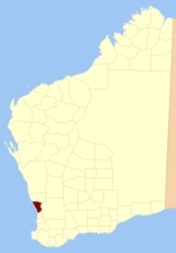
Swan Land District is one of the land districts
of Western Australia
, which is located within the South West Division. It covers all of the northern and eastern suburbs of Perth
, as well as some inner southern areas such as Belmont
and Applecross
(but not South Perth
) and the area to the north up to the Moore River
, including Muchea
and Gingin
. It is bounded on the north by the Melbourne Land District
; on the east by Avon Land District
; and on the south by Canning Land District
.
 It is subdivided into locations, including:
Cadastral divisions of Western Australia
The Lands administrative divisions of Western Australia refer to subdivisions of the state of Western Australia for cadastral purposes, most of which have been in place since the 19th century. The state is divided up for this purpose into five land divisions, which in turn are subdivided into land...
of Western Australia
Western Australia
Western Australia is a state of Australia, occupying the entire western third of the Australian continent. It is bounded by the Indian Ocean to the north and west, the Great Australian Bight and Indian Ocean to the south, the Northern Territory to the north-east and South Australia to the south-east...
, which is located within the South West Division. It covers all of the northern and eastern suburbs of Perth
Perth, Western Australia
Perth is the capital and largest city of the Australian state of Western Australia and the fourth most populous city in Australia. The Perth metropolitan area has an estimated population of almost 1,700,000....
, as well as some inner southern areas such as Belmont
Belmont, Western Australia
The City of Belmont is a Local Government Area in the inner eastern suburbs of the Western Australian capital city of Perth, located about east of Perth's central business district on the south bank of the Swan River...
and Applecross
Applecross, Western Australia
Applecross is an affluent riverside suburb of Perth, Western Australia, bounded by Canning Highway and the Swan River. It is located within the City of Melville.Like the name Perth, the suburb of Applecross borrows its name from the region in Scotland...
(but not South Perth
South Perth, Western Australia
South Perth is a residential suburb 3 kilometres south of the central business district of Perth, the capital of Western Australia, which adjoins the southern shore of Perth Water on the Swan River...
) and the area to the north up to the Moore River
Moore River (Western Australia)
Moore River is a river in the Wheatbelt of Western Australia.The headwaters of the river near Walebing and flow westerly before joining with the Moore river East near Mogumber then flow in a Westerly direction...
, including Muchea
Muchea, Western Australia
Muchea is a suburb of the Shire of Chittering. Its postcode is 6501.The towns name comes from the Aboriginal word "Muchela" which means in Nyoongar 'water hole', referring to the abundance of water in Muchea.- History :...
and Gingin
Gingin, Western Australia
Gingin is an agricultural town in Western Australia. The town is located north of Perth along the Brand Highway.The town is well suited for agriculture with a mild climate and available water sources...
. It is bounded on the north by the Melbourne Land District
Melbourne Land District
Melbourne Land District is a land district of Western Australia, located within the South West Division....
; on the east by Avon Land District
Avon Land District
Avon Land District is a land district of Western Australia, which is located within the South West Division. It covers areas of the Wheatbelt east and northeast of the capital, Perth. It is bounded on the west by Swan, to the northwest by Melbourne, to the north by Ninghan; on the east by Yilgarn...
; and on the south by Canning Land District
Canning Land District
Canning Land District is a land district of Western Australia, located within the South West Division in the eastern and south-eastern suburbs of metropolitan Perth....
.
Locations
- Location F-M, which extend west in long, narrow strips from the Swan River at CavershamCaversham, Western AustraliaCaversham is a suburb of Perth, Western Australia, located in the City of Swan....
, and were granted in 1829. - Location U-Z, extending northwest in narrow strips from the Swan River at MaylandsMaylands, Western AustraliaMaylands is a suburb located approximately northeast of Perth centred on the Midland railway line and located on the northern bank of the Swan River....
, also granted in 1829. - Location Au, which covers the inner northern suburbs of BalcattaBalcatta, Western AustraliaBalcatta is a suburb of Perth, Western Australia. Its Local Government Area is the City of Stirling. It is a primarily middle-class suburb made up of mainly Italian Catholic, Greek and Macedonian Orthodox families, as well as many families from other European Orthodox religions. It is also one of...
, Osborne ParkOsborne Park, Western AustraliaOsborne Park is a suburb of Perth, Western Australia. Its Local Government Area is the City of Stirling.Osborne Park was named after William Osborne, a butcher who owned an abattoir on Wanneroo Road and was elected to the Perth Road Board , in 1875.The suburb was originally full of market gardens,...
and Tuart HillTuart Hill, Western AustraliaTuart Hill is a suburb of Perth, Western Australia.Tuart Hill is named after the Tuart tree that once grew extensively throughout the area, especially around Dog Swamp...
. - Location 1315, which extends from northern HamersleyHamersley, Western AustraliaHamersley is a residential suburb 14 kilometres north-northwest of the central business district of Perth, the capital of Western Australia, and six kilometres from the Indian Ocean. The suburb adjoins two major arterial roads—Mitchell Freeway to the west and Reid Highway to the...
to Lake Goollelal, and west to the coast. - Location 1352, a rural location past the northern suburban limits of Perth.
- Location 1370, a vast location extending from HillarysHillarys, Western AustraliaHillarys is a northern coastal suburb of Perth, the capital city of Western Australia. Its Local Government Area is the City of Joondalup. It is part of the Whitfords precinct, and is located 21 km north-northwest of Perth's central business district via Mitchell Freeway and Hepburn...
to north of YanchepYanchep, Western AustraliaYanchep is an outer coastal suburb of Perth, Western Australia, located 56 kilometres north of Perth's central business district. It is part of the City of Wanneroo local government area. It was built by entrepreneur Alan Bond in the 1970s for the 1977 America's Cup...
.