

Cadastral divisions of Western Australia
Encyclopedia
The Lands administrative divisions of Western Australia refer to subdivisions of the state of Western Australia
for cadastral (land title) purposes, most of which have been in place since the 19th century. The state is divided up for this purpose into five land divisions, which in turn are subdivided into land districts, which correspond to counties in other Australian states. These districts are then subdivided further into numbered locations, as well as gazetted townsites. Together, they form part of the lands administrative divisions of Australia.
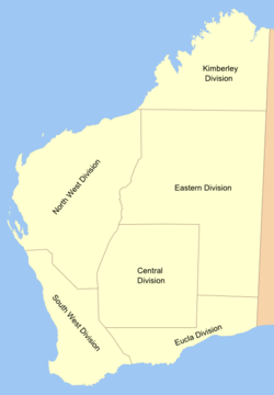 There are five land divisions in Western Australia, as specified in Schedule 1 of the Land Administration Act 1997.
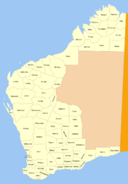
The Rabbit-proof fence
is the border between the North West and South West divisions on the western side, and the others on the eastern side. In practical terms, the divisions are rarely used — in 1897, the Under Secretary for Lands described their purpose as "really only for the purpose of classifying land for Pastoral Leases."
The system of divisions developed as follows:
 The land district is the highest level of land division actively used in Western Australian land titles, and has been in use in some form since the earliest days of the Swan River Colony
, although only achieved statutory recognition with the enactment of section 7 the Land Act 1898. They are recognised today through section 26 of the Land Administration Act 1997. Under the system in place, there are two methods of distributing titles within a district: one is to gazette a townsite from land within the district and henceforth treat it entirely separately from the district; the other is to create locations (almost always numeric) within districts, such as Windell Location 7 or Swan Location 1315, and then either dedicate the location as a reserve with reference to the Governor's powers under the 1997 Act, grant the location in fee simple
to an individual or company, or subdivide it into lots for sale or lease.
in London for "the division of the whole of the territory of Western Australia into Counties, Hundreds and Parishes of fixed size". However, the system was all but abandoned within a few years, and district names were simply applied to areas without any effort to fix boundaries for them. Areas within declared townsites were managed separately.
At this time, the population of the colony was small, and the Governor
had complete control over the affairs of the state, receiving advice from experts such as the Surveyor General
, who was responsible for the Department of Lands and Surveys. In 1890, the colony achieved responsible government
, and in 1892–1893, gold was discovered in the Kalgoorlie region, leading to a gold rush. In 1895–1896, the Department, by now quite overwhelmed, attempted to define boundaries for districts based on where land had already been granted, but the result was irregular boundaries which did not follow natural features. Furthermore, in assigning and alienating the land, the Department's officers were in somewhat uncharted territory due to the mix of pre-1890 regulations from the Governor with overly specific statutes from the legislature (such as the Homestead Act 1893 and Transfer of Land Act 1892) that they had to navigate. The Under Secretary for Lands noted in August 1896 that "there is no provision in any Act or Regulations for the declaration of land districts... it is only an office arrangement".
The Surveyor General and his staff agitated for a "Consolidated Land Bill" which would consolidate then repeal all previous arrangements, provide a statutory framework which recognised existing practice, and establish a more formal method for establishing and recording land districts. New broad-acre settlements in areas of the colony not already covered by districts (most notably at Carnarvon
and Esperance
) made the matter more urgent.
In the interim, the Department started two new files at the beginning of 1897 which ultimately recorded the correspondence between the Chief Draftsman, Surveyor General, Under Secretary for Lands and the responsible Minister in setting up a consistent means of generating and naming new land districts which would form the basis of a statutory system once one emerged, and 25 new districts had been approved by year's end.
On 1 January 1899, the Land Act took effect, and the Department's new system became the norm, with the only change being that all new districts or changes to existing ones were printed in the Government Gazette. Until 1902, with only some exceptions, names used were usually those of explorers or early settlers, but in 1902, the Surveyor General rejected a suggested list of new names, advising the Chief Draftsman that "I should much prefer euphonious native names if they can be obtained for these proposed new districts, as I think we should lose no opportunity of perpetuating the nomenclature of a fast disappearing race, apart from which the liability of duplicating names is largely increased if the surnames of individuals are devoted to land districts." Between 1902 and 1906, a considerable rush to gazette new districts was promoted by the desire to impress land agents in London — the Minister noted that "it will not hurt the State to show as few blanks as possible". Prior to the construction of the Trans-Australian Railway
, the Eastern Division, which consists almost entirely of the Great Victoria
and Great Sandy
Deserts, did not contain any districts.
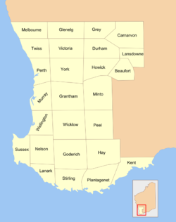 Historically, there were 26 counties in the south-western part of the state, designated shortly after the Swan River Colony
was founded in 1829. It was originally intended for these to be subdivided into hundreds and parishes in a manner similar to South Australia, but this did not occur, as the division/district system took precedence.
Western Australia
Western Australia is a state of Australia, occupying the entire western third of the Australian continent. It is bounded by the Indian Ocean to the north and west, the Great Australian Bight and Indian Ocean to the south, the Northern Territory to the north-east and South Australia to the south-east...
for cadastral (land title) purposes, most of which have been in place since the 19th century. The state is divided up for this purpose into five land divisions, which in turn are subdivided into land districts, which correspond to counties in other Australian states. These districts are then subdivided further into numbered locations, as well as gazetted townsites. Together, they form part of the lands administrative divisions of Australia.
Land divisions
- Eastern Land Division
- Eucla Land Division
- Kimberley Land Division
- North-West Land Division
- South-West Land Division
The Rabbit-proof fence
Rabbit-proof fence
The State Barrier Fence of Western Australia, formerly known as the No. 1 Rabbit-proof Fence, the State Vermin Fence and the Emu Fence, is a pest-exclusion fence constructed between 1901 and 1907 to keep rabbits and other agricultural pests, from the east, out of Western Australian pastoral...
is the border between the North West and South West divisions on the western side, and the others on the eastern side. In practical terms, the divisions are rarely used — in 1897, the Under Secretary for Lands described their purpose as "really only for the purpose of classifying land for Pastoral Leases."
The system of divisions developed as follows:
| Date enacted | Divisions | Enabling Act | Maps |
|---|---|---|---|
| 11 October 1882 | Central, Central-Eastern, South-Eastern, North, Kimberley | Land Regulations | |
| 2 March 1887 | South-West, Kimberley, North-West, Gascoyne Gascoyne Land Division Gascoyne Land Division was a land division of Western Australia defined under the Land Regulations of 2 March 1887. It included almost all of the modern Gascoyne region of the State... , Eucla, Eastern |
Land Regulations, s.39 | |
| 1 January 1899 | South-West, Kimberley, North-West, Western Gascoyne Land Division Gascoyne Land Division was a land division of Western Australia defined under the Land Regulations of 2 March 1887. It included almost all of the modern Gascoyne region of the State... , Eucla, Eastern |
Land Act 1898, s. 38 | |
| 1 February 1907 | South-West, Kimberley, North-West, Central, Eucla, Eastern | Land Act Amendment Act 1906, s. 26 | |
| 28 March 1917 | As above, but merged Central into Eastern | Land Act Amendment Act 1917 (No. 19), s. 4 | |
| 6 March 1934 | As above | Land Act 1933 (No. 37), s. 28 | |
| 30 March 1998 | As above | Land Administration Act 1997 (No. 30), s. 6 and Sch. 1 |
- See also: Regions of Western AustraliaRegions of Western AustraliaRegionalisations of Western Australia are systems by which Western Australia is divided into distinct geographic regions. The most commonly known regionalisation is the governmental division of the state into regions for economic development purposes, of which there are nine.Other regionalisations...
for a similar break-up of Western Australia to that of divisions
Land districts
Swan River Colony
The Swan River Colony was a British settlement established in 1829 on the Swan River, in Western Australia. The name was a pars pro toto for Western Australia. In 1832, the colony was officially renamed Western Australia, when the colony's founding Lieutenant-Governor, Captain James Stirling,...
, although only achieved statutory recognition with the enactment of section 7 the Land Act 1898. They are recognised today through section 26 of the Land Administration Act 1997. Under the system in place, there are two methods of distributing titles within a district: one is to gazette a townsite from land within the district and henceforth treat it entirely separately from the district; the other is to create locations (almost always numeric) within districts, such as Windell Location 7 or Swan Location 1315, and then either dedicate the location as a reserve with reference to the Governor's powers under the 1997 Act, grant the location in fee simple
Fee simple
In English law, a fee simple is an estate in land, a form of freehold ownership. It is the most common way that real estate is owned in common law countries, and is ordinarily the most complete ownership interest that can be had in real property short of allodial title, which is often reserved...
to an individual or company, or subdivide it into lots for sale or lease.
History
In 1831, instructions were issued from the Colonial SecretarySecretary of State for the Colonies
The Secretary of State for the Colonies or Colonial Secretary was the British Cabinet minister in charge of managing the United Kingdom's various colonial dependencies....
in London for "the division of the whole of the territory of Western Australia into Counties, Hundreds and Parishes of fixed size". However, the system was all but abandoned within a few years, and district names were simply applied to areas without any effort to fix boundaries for them. Areas within declared townsites were managed separately.
At this time, the population of the colony was small, and the Governor
Governor of Western Australia
The Governor of Western Australia is the representative in Western Australia of Australia's Monarch, Queen Elizabeth II. The Governor performs important constitutional, ceremonial and community functions, including:* presiding over the Executive Council;...
had complete control over the affairs of the state, receiving advice from experts such as the Surveyor General
Surveyor General of Western Australia
The Surveyor General of Western Australia is the person nominally responsible for government surveying in Western Australia.In the early history of Western Australia, the office of surveyor general was one of the most important public offices...
, who was responsible for the Department of Lands and Surveys. In 1890, the colony achieved responsible government
Responsible government
Responsible government is a conception of a system of government that embodies the principle of parliamentary accountability which is the foundation of the Westminster system of parliamentary democracy...
, and in 1892–1893, gold was discovered in the Kalgoorlie region, leading to a gold rush. In 1895–1896, the Department, by now quite overwhelmed, attempted to define boundaries for districts based on where land had already been granted, but the result was irregular boundaries which did not follow natural features. Furthermore, in assigning and alienating the land, the Department's officers were in somewhat uncharted territory due to the mix of pre-1890 regulations from the Governor with overly specific statutes from the legislature (such as the Homestead Act 1893 and Transfer of Land Act 1892) that they had to navigate. The Under Secretary for Lands noted in August 1896 that "there is no provision in any Act or Regulations for the declaration of land districts... it is only an office arrangement".
The Surveyor General and his staff agitated for a "Consolidated Land Bill" which would consolidate then repeal all previous arrangements, provide a statutory framework which recognised existing practice, and establish a more formal method for establishing and recording land districts. New broad-acre settlements in areas of the colony not already covered by districts (most notably at Carnarvon
Carnarvon, Western Australia
Carnarvon is a coastal town situated approximately 900 kilometres north of Perth, Western Australia. It lies at the mouth of the Gascoyne River on the Indian Ocean. The popular Shark Bay world heritage area lies to the south of the town and the Ningaloo Reef lies to the north...
and Esperance
Esperance, Western Australia
Esperance is a large town in the Goldfields-Esperance region of Western Australia, located on the Southern Ocean coastline approximately east-southeast of the state capital, Perth. The shire of Esperance is home to 9,536 people as of the 2006 census, its major industries are tourism, agriculture,...
) made the matter more urgent.
In the interim, the Department started two new files at the beginning of 1897 which ultimately recorded the correspondence between the Chief Draftsman, Surveyor General, Under Secretary for Lands and the responsible Minister in setting up a consistent means of generating and naming new land districts which would form the basis of a statutory system once one emerged, and 25 new districts had been approved by year's end.
On 1 January 1899, the Land Act took effect, and the Department's new system became the norm, with the only change being that all new districts or changes to existing ones were printed in the Government Gazette. Until 1902, with only some exceptions, names used were usually those of explorers or early settlers, but in 1902, the Surveyor General rejected a suggested list of new names, advising the Chief Draftsman that "I should much prefer euphonious native names if they can be obtained for these proposed new districts, as I think we should lose no opportunity of perpetuating the nomenclature of a fast disappearing race, apart from which the liability of duplicating names is largely increased if the surnames of individuals are devoted to land districts." Between 1902 and 1906, a considerable rush to gazette new districts was promoted by the desire to impress land agents in London — the Minister noted that "it will not hurt the State to show as few blanks as possible". Prior to the construction of the Trans-Australian Railway
Trans-Australian Railway
The Trans-Australian Railway crosses the Nullarbor Plain of Australia from Port Augusta in South Australia to Kalgoorlie in Western Australia...
, the Eastern Division, which consists almost entirely of the Great Victoria
Great Victoria Desert
The Great Victoria Desert is a barren and sparsely populated desert area of southern Australia.-Location and description:The Great Victoria is the biggest desert in Australia and consists of many small sandhills, grassland plains, areas with a closely packed surface of pebbles and salt lakes...
and Great Sandy
Great Sandy Desert
The Great Sandy Desert is a desert located in the North West of Western Australia straddling the Pilbara and southern Kimberley regions. It is the second largest desert in Australia after the Great Victoria Desert and encompasses an area of...
Deserts, did not contain any districts.
List of land districts
The list below represents a complete list of land districts, together with the division of which they are part and the year where they came into being — either through granting of locations prior to 1896, delineation in Department files between 1896 and 1898, or gazettal from 1899 onwards.| District | Division | Location | Created | Notes |
|---|---|---|---|---|
| Ashburton Ashburton Land District Ashburton Land District is a land district of Western Australia, located within the North-West Land Division.... |
North-West | 21°57′S 115°32′E | 1897 | |
| Avon Avon Land District Avon Land District is a land district of Western Australia, which is located within the South West Division. It covers areas of the Wheatbelt east and northeast of the capital, Perth. It is bounded on the west by Swan, to the northwest by Melbourne, to the north by Ninghan; on the east by Yilgarn... |
South-West | 31°36′S 117°02′E | 1833 | |
| Balladonia Balladonia Land District Balladonia Land District is a land district of Western Australia mostly within the Eucla Land Division. It spans roughly 31°50'S - 32°40'S in latitude and 123°10'E - 124°00'E in longitude.-Location and features:... |
Eucla Eastern |
32°15′S 123°35′E | 1897 | |
| Balwina Balwina Land District Balwina Land District is a land district of Western Australia, located within the Eastern Land Division in the Great Sandy Desert... |
Eastern | 20°15′S 127°40′E | 1928 | |
| Bulara Bulara Land District Bulara Land District is a land district of Western Australia, located within the Kimberley Division of the state.... |
Kimberley | 19°10′S 128°10′E | 1906 | |
| Bulga Bulga Land District Bulga Land District is a land district of Western Australia, located within the Eastern Land Division.... |
Eastern | 28°25′S 119°40′E | 1903 | |
| Buningonia Buningonia Land District Buningonia Land District is a land district of Western Australia, located within the Eastern Land Division on the Nullarbor Plain. It spans roughly 30°10'S - 32°00'S in latitude and 122°15'E - 124°00'E in longitude.-Location and features:... |
Eastern | 31°05′S 123°05′E | 1903 | |
| Canning Canning Land District Canning Land District is a land district of Western Australia, located within the South West Division in the eastern and south-eastern suburbs of metropolitan Perth.... |
South-West | 32°10′S 115°57′E | 1833 | |
| Cockburn Sound Cockburn Sound Land District Cockburn Sound Land District is a land district of Western Australia, located within the South West Division.... |
South-West | 32°20′S 115°50′E | 1833 | |
| Dampier Dampier Land District Dampier Land District is a land district of Western Australia, located within the Kimberley Division of the state.... |
Kimberley | 17°40′S 122°40′E | 1897 | |
| De Grey De Grey Land District De Grey Land District is a land district of Western Australia and a subdivision of the North-West Land Division. It includes the Pilbara towns of Marble Bar and Nullagine and the former town of Goldsworthy.... |
North-West | 21°20′S 120°05′E | 1906 | |
| De Witt De Witt Land District De Witt District is a land district of Western Australia, located within the North-West Land Division.... |
North-West | 21°05′S 116°20′E | 1897 | |
| Delisser Delisser Land District Delisser Land District is a land district of Western Australia, located within the Eastern and Eucla land divisions on the Nullarbor Plain. It spans roughly 29°00'S - 31°00'S in latitude and 126°30'E - 129°00'E in longitude.... |
Eucla Eastern |
30°00′S 127°45′E | 1916 | |
| Dempster Dempster Land District Dempster Land District is a land district of Western Australia, located within the Eucla Land Division.... |
Eucla | 32°40′S 122°55′E | 1897 | |
| Doongan Doongan Land District Doongan Land District is a land district of Western Australia, located within the Kimberley Land Division in the Kimberley region of the state.-Location and features:... |
Kimberley | 14°50′S 126°40′E | 1906 | Previously spelt Dungan |
| Dundas Dundas Land District Dundas Land District is a land district of Western Australia within the Eucla Land Division. It spans roughly 31°40'S - 32°40'S in latitude and 121°00'E - 122°15'E in longitude.-Location and features:... |
Eucla | 32°10′S 121°50′E | 1897 | |
| Easton Easton Land District Easton Land District is a land district of Western Australia, located within the Kimberley Land Division in the Kimberley region of the state.-Location and features:... |
Kimberley | 15°55′S 125°05′E | 1906 | Formerly known as Kwinana |
| Edel Edel Land District Edel Land District is a land district of Western Australia, located within the North-West Land Division.... |
North-West | 26°40′S 113°40′E | 1897 | |
| Edjudina Edjudina Land District Edjudina Land District is a land district of Western Australia, located within the Eastern Land Division.... |
Eastern | 29°25′S 122°35′E | 1903 | |
| Erivilla Erivilla Land District Erivilla Land District is a land district of Western Australia, located within the North-West Land Division.... |
North-West | 25°35′S 117°50′E | 1897 | |
| Esperance Esperance Land District Esperance Land District is a land district of Western Australia, located within the Eucla Land Division on the state's south coast... |
Eucla | 33°40′S 121°40′E | 1896 | |
| Fitzgerald Fitzgerald Land District Fitzgerald Land District is a land district of Western Australia, located within the Eucla Land Division inland from Esperance... |
Eucla | 32°55′S 121°37′E | 1896 | |
| Fitzroy Fitzroy Land District Fitzroy Land District is a land district of Western Australia, located within the Kimberley Division of the state.... |
Kimberley | 17°55′S 124°50′E | 1897 | |
| Forrest Forrest Land District Forrest Land District is a land district of Western Australia and a subdivision of the North-West Land Division. It contains the towns of Port Hedland and South Hedland.... |
North-West | 21°25′S 118°55′E | 1897 | |
| Fraser Fraser Land District Fraser Land District is a land district of Western Australia partly within the Eucla and Eastern divisions of the state. It spans roughly 31°40'S - 32°25'S in latitude and 122°15'E - 123°10'E in longitude.-Location and features:... |
Eucla Eastern |
32°00′S 122°45′E | 1897 | |
| Gascoyne Gascoyne Land District Gascoyne Land District is a land district of Western Australia, located within the North-West Land Division.... |
North-West | 24°50′S 114°25′E | 1897 | |
| Giles Giles Land District Giles Land District is a land district of Western Australia, located within the Eastern and Eucla land divisions on the Nullarbor Plain. It spans roughly 29°00'S - 31°00'S in latitude and 123°30'E - 126°30'E in longitude.... |
Eucla Eastern |
30°00′S 125°20′E | 1916 | |
| Gregory Gregory Land District Gregory Land District is a land district of Western Australia, located within the North-West Land Division.... |
North-West | 22°25′S 117°20′E | 1897 | |
| Hampton Hampton Land District Hampton Land District is a land district of Western Australia, located within the Eastern Land Division in the Goldfields region of the state.-Location and features:... |
Eastern | 30°50′S 121°40′E | 1899 | |
| Hann Hann Land District Hann Land District is a land district of Western Australia, located within the Eastern Land Division of the state. It spans roughly 24°00'S - 25°40'S in latitude and 120°00'E - 121°40'E in longitude, east of the rabbit-proof fence. Part of the Canning Stock Route passes through the south-east of... |
Eastern | 24°50′S 120°50′E | 1925 | |
| Hardey Hardey Land District Hardey Land District is a land district of Western Australia, located within the North-West Land Division.... |
North-West | 23°20′S 117°50′E | 1897 | |
| Hay Hay Land District Hay Land District is a land district of Western Australia, located within the South West Division.... |
South-West | 34°40′S 117°14′E | 1857 | |
| Jarmura Jarmura Land District Jarmura Land District is a land district of Western Australia, located within the Kimberley Division of the state.... |
Kimberley | 18°40′S 124°25′E | 1906 | |
| Jaurdi Jaurdi Land District Jaurdi Land District is a land district of Western Australia, located within the Eastern Land Division.... |
Eastern | 30°25′S 120°50′E | 1903 | |
| Jilbadji Jilbadji Land District Jilbadji Land District is a land district of Western Australia, located within the Eastern Land Division.... |
Eastern | 31°25′S 119°25′E | 1903 | |
| Kaluwiri Kaluwiri Land District Kaluwiri Land District is a land district of Western Australia, located within the Eastern Land Division.... |
Eastern | 27°50′S 120°40′E | 1903 | |
| Kent Kent Land District, Western Australia Kent Land District is a land district of Western Australia, located within the South West Division.... |
South-West | 33°50′S 118°50′E | 1857 | |
| King King Land District King Land District is a land district of Western Australia, located within the Kimberley Division of the state.... |
Kimberley | 15°50′S 128°40′E | 1899 | |
| Kojonup Kojonup Land District Kojonup Land District is a land district of Western Australia, located within the South West Division.... |
South-West | 33°40′S 117°35′E | 1840 | |
| Koondra Koondra Land District Koondra Land District is a land district of Western Australia and a subdivision of the North-West Land Division, located in the Pilbara region of the state.-Location:... |
North-West | 23°35′S 120°05′E | 1906 | Previously spelt Kundra |
| Kyarra Kyarra Land District Kyarra Land District is a land district of Western Australia, located within the North-West Land Division.It contains the towns of Cue and Meekatharra, and the former towns of Nannine and Austin.... |
North-West | 26°50′S 118°20′E | 1897 | |
| Leake Leake Land District Leake Land District is a land district of Western Australia, located within the Eucla Land Division.... |
Eucla | 32°25′S 120°25′E | 1903 | |
| Luman Luman Land District Luman Land District is a land district of Western Australia, located within the Kimberley Division of the state.... |
Kimberley | 17°20′S 128°10′E | 1906 | |
| Lyndon Lyndon Land District Lyndon Land District is a land district of Western Australia, located within the North-West Land Division.... |
North-West | 23°10′S 114°40′E | 1897 | |
| Lyons Lyons Land District Lyons Land District is a land district of Western Australia, located within the North-West Land Division.... |
North-West | 24°50′S 116°25′E | 1897 | |
| Malcolm Malcolm Land District Malcolm Land District is a land district of Western Australia, located within the Eastern Land Division in the northern Goldfields region of the state.-Location and features:... |
Eastern | 28°50′S 121°20′E | 1900 | |
| Mardarbilla Mardarbilla Land District Mardarbilla Land District is a land district of Western Australia located within the Eucla Land Division on the western edge of the Great Australian Bight. It spans roughly 32°40'S - 33°55'S in latitude and 123°30'E - 124°00'E in longitude... |
Eucla | 33°25′S 123°45′E | 1897 | |
| Marmion Marmion Land District Marmion Land District is a land district of Western Australia, located within the Eastern Land Division.... |
Eastern | 29°40′S 121°10′E | 1899 | |
| Marndoc Marndoc Land District Marndoc Land District is one of the land districts of Western Australia, located within the Kimberley Division of the state.... |
Kimberley | 15°10′S 127°40′E | 1906 | |
| Meda Meda Land District Meda Land District is one of the land districts of Western Australia, located within the Kimberley Division of the state.... |
Kimberley | 16°40′S 123°50′E | 1897 | |
| Melbourne Melbourne Land District Melbourne Land District is a land district of Western Australia, located within the South West Division.... |
South-West | 30°40′S 116°10′E | 1848 | |
| Milyuga Milyuga Land District Milyuga Land District is a land district of Western Australia, located within the Eastern Land Division in the Gibson Desert... |
Eastern | 25°25′S 127°25′E | 1932 | |
| Mundrabilla Mundrabilla Land District Mundrabilla Land District is a land district of Western Australia, located within the Eucla Land Division on the Nullarbor Plain... |
Eucla | 31°30′S 128°15′E | 1903 | |
| Murchison Murchison Land District Murchison Land District is a land district of Western Australia, located within the North-West Land Division.... |
North-West | 26°40′S 115°40′E | 1897 | |
| Murray Murray Land District Murray Land District is a land district of Western Australia, located within the South-West Land Division on the state's west coast... |
South-West | 32°40′S 116°05′E | 1837 | |
| Nabberu Nabberu Land District Nabberu Land District is a land district of Western Australia, located within the Eastern Land Division.... |
Eastern | 26°35′S 120°10′E | 1903 | |
| Nelson Nelson Land District Nelson Land District is a land district of Western Australia, located within the South West Division on the state's south coast... |
South-West | 34°10′S 116°10′E | 1858 | |
| Neridup Neridup Land District Neridup Land District is a land district of Western Australia, located within the Eucla Land Division on the state's south coast... |
Eucla | 33°40′S 122°55′E | 1896 | |
| Ngalbain Ngalbain Land District Ngalbain Land District is a land district of Western Australia, located within the Eastern Land Division.... |
Eastern | 31°20′S 121°10′E | 1903 | |
| Ninghan Ninghan Land District Ninghan Land District is a land district of Western Australia partly within the North-West and South-West divisions.... |
North-West South-West |
30°10′S 117°35′E | 1897 | |
| Nookawarra Nookawarra Land District Nookawarra Land District is a land district of Western Australia, located within the North-West Land Division.... |
North-West | 26°50′S 117°10′E | 1897 | |
| Nuleri Nuleri Land District Nuleri Land District is a land district of Western Australia, located within the Eastern Land Division.... |
Eastern | 27°40′S 122°10′E | 1903 | |
| Numalgun Numalgun Land District Numalgun Land District is a land district of Western Australia, located within the Kimberley Land Division in the Kimberley region of the state.-Location and features:... |
Kimberley | 16°40′S 125°50′E | 1906 | |
| Nurina Nurina Land District Nurina Land District is a land district of Western Australia, located within the Eucla Land Division on the Nullarbor Plain... |
Eucla | 31°40′S 126°30′E | 1903 | |
| Nuyts Nuyts Land District Nuyts Land District is a land district of Western Australia, located within the Eastern and Eucla land divisions on the Nullarbor Plain... |
Eucla | 31°35′S 124°40′E | 1903 | |
| Oldfield Oldfield Land District Oldfield Land District is a land district of Western Australia partly within the Eucla and South-West divisions on the state's south coast... |
Eucla South-West |
33°40′S 120°25′E | 1896 | |
| Omalinde Omalinde Land District Omalinde Land District is one of the land districts of Western Australia, located within the Kimberley Division of the state.... |
Kimberley | 16°20′S 127°10′E | 1906 | |
| Pardu Pardu Land District Pardu Land District is a land district of Western Australia partly within the Kimberley, Eastern and North-West divisions of the state.... |
Kimberley Eastern North-West |
19°50′S 120°40′E | 1906 | |
| Peawah Peawah Land District Peawah Land District is a land district of Western Australia, located within the North-West Land Division.... |
North-West | 21°20′S 117°40′E | 1897 | |
| Plantagenet Plantagenet Land District Plantagenet Land District is a land district of Western Australia, located within the South West Division.... |
South-West | 34°20′S 117°50′E | 1833 | |
| Roe Roe Land District Roe Land District is a land district of Western Australia, located within the South-West Land Division in the eastern Wheatbelt region of the state.-History:... |
South-West | 32°50′S 119°10′E | 1899 | |
| Sussex Sussex Land District Sussex Land District is a land district of Western Australia, located within the South-West Land Division on the state's west coast... |
South-West | 33°55′S 115°05′E | 1840 | |
| Swan Swan Land District Swan Land District is one of the land districts of Western Australia, which is located within the South West Division. It covers all of the northern and eastern suburbs of Perth, as well as some inner southern areas such as Belmont and Applecross and the area to the north up to the Moore River,... |
South-West | 31°20′S 115°50′E | 1833 | |
| Teano Teano Land District Teano Land District is a land district of Western Australia, located within the North-West Land Division.... |
North-West | 24°25′S 118°50′E | 1906 | |
| Thadoona Thadoona Land District Thadoona Land District is a land district of Western Australia and a subdivision of the North-West Land Division located in the Mid West region of the state.-Location and features:... |
North-West | 25°25′S 119°40′E | 1903 | Previously spelt Thaduna |
| Tugaila Tugaila Land District Tugaila Land District is a land district of Western Australia, located within the Eastern Land Division in the Gibson Desert. It spans roughly 24°00'S - 26°50'S in latitude and 123°20'E - 125°50'E in longitude.-History:... |
Eastern | 25°25′S 124°25′E | 1932 | |
| Ularring Ularring Land District Ularring Land District is a land district of Western Australia, located within the Eastern Land Division.... |
Eastern | 29°25′S 120°05′E | 1903 | |
| Victoria Victoria Land District Victoria Land District is a land district of Western Australia partly within the North-West and South-West divisions of the state.... |
North-West South-West |
29°10′S 115°25′E | 1853 | |
| Wanman Wanman Land District Wanman Land District is a land district of Western Australia, located within the Eastern Land Division. Little is known of this district, which was created after 1950 and was in use by 1988. The district is believed to be located in the Shire of East Pilbara and the Shire of... |
Eastern | 22°10′S 123°50′E | 1950s | |
| Warramboo Warramboo Land District Warramboo Land District is a land district of Western Australia, located within the North-West Land Division.It contains the town of Mount Magnet and the former towns of Boogardie, Lennonville and Paynesville.... |
North-West | 28°05′S 117°50′E | 1897 | |
| Weld Weld Land District Weld Land District is one of the land districts of Western Australia, which is located within the Eastern Land Division in the north-eastern Goldfields region of the state.-Location:... |
Eastern | 28°40′S 122°25′E | 1901 | |
| Wellington | South-West | 33°10′S 115°50′E | 1835 | |
| Wells Wells Land District Wells Land District is a land district of Western Australia, located within the Eastern Land Division of the state. It spans roughly 24°00'S - 26°20'S in latitude and 121°40'E - 123°20'E in longitude... |
Eastern | 25°15′S 122°30′E | 1925 | |
| Williams Williams Land District Williams Land District is a land district of Western Australia, located within the South West Division.... |
South-West | 32°50′S 117°50′E | 1835 | |
| Windell Windell Land District Windell Land District is a land district of Western Australia and a subdivision of the North-West Land Division. It contains Newman, Paraburdoo and the former town of Wittenoom.-References:... |
North-West | 22°55′S 119°35′E | 1897 | |
| Yamarna Yamarna Land District Yamarna Land District is a land district of Western Australia, located within the Eastern Land Division in the Great Victoria Desert, north of the Nullarbor Plain... |
Eastern | 28°10′S 123°40′E | 1930 | |
| Yelina Yelina Land District Yelina Land District is a land district of Western Australia, located within the Eastern Land Division.... |
Eastern | 26°20′S 122°10′E | 1903 | |
| Yilgarn Yilgarn Land District Yilgarn Land District is a land district of Western Australia, located within the Eastern Land Division.... |
Eastern | 30°50′S 119°05′E | 1900 | |
| Yowalga Yowalga Land District Yowalga Land District is a land district of Western Australia, located within the Eastern Land Division in the Great Victoria Desert, north of the Nullarbor Plain... |
Eastern | 27°55′S 127°00′E | 1932 | |
| Yurabi Yurabi Land District Yurabi Land District is one of the land districts of Western Australia, located within the Kimberley Division of the state. The name of the district is sometimes spelt Yooraby.... |
Kimberley | 18°55′S 125°32′E | 1906 |
Counties
Swan River Colony
The Swan River Colony was a British settlement established in 1829 on the Swan River, in Western Australia. The name was a pars pro toto for Western Australia. In 1832, the colony was officially renamed Western Australia, when the colony's founding Lieutenant-Governor, Captain James Stirling,...
was founded in 1829. It was originally intended for these to be subdivided into hundreds and parishes in a manner similar to South Australia, but this did not occur, as the division/district system took precedence.
- Beaufort CountyBeaufort County, Western AustraliaBeaufort County was one of the 26 counties of Western Australia that were designated in 1829 as cadastral divisions. It approximately corresponds to the far eastern end of the Avon Land District which forms the basis for land titles in the area....
- Carnarvon County
- Durham CountyDurham County, Western AustraliaDurham County was one of the 26 counties of Western Australia that were designated in 1829 as cadastral divisions. It approximately corresponds to the north-eastern part of the Avon Land District which forms the basis for land titles in the area....
- Glenelg County
- Goderich County
- Grantham County
- Grey CountyGrey County, Western AustraliaGrey County was one of the 26 counties of Western Australia that were designated in 1829 as cadastral divisions. It approximately corresponds to the southern part of the Ninghan Land District which forms the basis for land titles in the area....
- Hay County
- Howick County
- Kent CountyKent County, Western AustraliaKent County was one of the 26 counties of Western Australia that were designated in 1829. It is part of the cadastral divisions of Australia. The counties were used throughout the South western region of Western Australia....
- Lanark CountyLanark County, Western AustraliaLanark County was one of the 26 counties of Western Australia that were designated in 1829 as cadastral divisions. It approximately corresponds to the southern part of the Nelson Land District which forms the basis for land titles in the area....
- Lansdowne County
- Melbourne County
- Minto County
- Murray CountyMurray County, Western AustraliaMurray County was one of the 26 counties of Western Australia that were designated in 1829 as cadastral divisions. It approximately corresponds to the Murray Land District and part of the Cockburn Sound Land District which form the basis for land titles in the area....
- Nelson CountyNelson County, Western AustraliaNelson County was one of the 26 counties of Western Australia that were designated in 1829 as cadastral divisions. It approximately corresponds to the northern part of the Nelson Land District which forms the basis for land titles in the area....
- Peel CountyPeel County, Western AustraliaPeel County was one of the 26 counties of Western Australia that were designated in 1829 as cadastral divisions. It approximately corresponds to the eastern part of the Williams Land District which forms the basis for land titles in the area....
- Plantagenet CountyPlantagenet County, Western AustraliaPlantagenet County was one of the 26 counties of Western Australia that were designated in 1829 as cadastral divisions, and was centred on the coastal settlement of Albany. It approximately corresponds to the modern-day Plantagenet Land District which forms the basis for land titles in the area.-...
- Perth County
- Stirling CountyStirling County, Western AustraliaStirling County was one of the 26 counties of Western Australia that were designated in 1829 as cadastral divisions. It approximately corresponds to the southern part of the Hay Land District which forms the basis for land titles in the area....
- Sussex CountySussex County, Western AustraliaSussex County was one of the 26 counties of Western Australia that were designated in 1829 as cadastral divisions. It approximately corresponds to the modern-day Sussex Land District which forms the basis for land titles in the area....
- Twiss County
- Victoria CountyVictoria County, Western AustraliaVictoria County was one of the twenty six counties of Western Australia that were designated in 1829. It approximately corresponds to the north-western section of the Avon Land District which forms the basis for land titles in the area....
- Wellington CountyWellington County, Western AustraliaWellington County was one of the 26 counties of Western Australia that were designated in 1829 as cadastral divisions. It approximately corresponds to the Wellington Land District which forms the basis for land titles in the area....
- Wicklow CountyWicklow County, Western AustraliaWicklow County was one of the 26 counties of Western Australia that were designated in 1829 as cadastral divisions. It approximately corresponds to the western part of the Williams Land District which forms the basis for land titles in the area....
- York CountyYork County, Western AustraliaYork County was one of the 26 counties of Western Australia that were designated in 1829 as cadastral divisions. It approximately corresponds to the western part of the Avon Land District which forms the basis for land titles in the area....