
Suttons Bay, Michigan
Encyclopedia
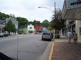
Suttons Bay is a village in Leelanau County
in the U.S. state
of Michigan
. The population was 589 at the 2000 census
. The village was incorporated in 1898 and is located within Suttons Bay Township
.
The community is named for one of the first settlers of European descent, Harry C. Sutton, who arrived in 1854. He arrived with a crew of woodsmen to supply fuel for passing wood steamboats.
In 1903 the Traverse City, Leelanau, and Manistique Railroad began a route between Traverse City to the South and Northport to the North, stopping at Suttons Bay, as well as Hatch's Crossing, Fountain Point, Bingham, Keswick, and Omena.
Before the turn of the 20th century, four churches had been established—two Lutheran, one Roman Catholic, and one Congregational.
In 1920, Leelanau County voters approved moving the county seat
to Suttons Bay, but the move never took place.
Suttons Bay has a school; the sports mascot is a viking, hence the nickname "Suttons Bay Norsemen."
The town is home to the county's only movie theater, opened in 1946. It is now owned by Bob Bahle, and was renovated in 1977. Its fare consists of unique art house films, and occasionally the theater hosts plays and concerts.
The town has a clothing store that has been owned by one family over four generations called "Bahles." The original store started as a "dry-goods" business in 1876 by Lars Bahle, an immigrant from Norway.
Anna Hawkins married Patrick Hawkins in 1943 and moved to the family farm located four miles south of town while Patrick served in the U.S. Army in Italy.
Activities in Suttons Bay include the Suttons Bay Jazzfest and the Suttons Bay Art Festival.
Suttons Bay is home to the Inland Seas Education Association, educating school age youth on the Great Lakes by use of the Inland Seas schoolship.
Famous residents include Dean Robb, a nationally recognized attorney.
Suttons Bay also is highly embedded in the cherry industry, producing sweet and tart cherries of many varieties. Harvest operations usually take place in mid-July and run into August.
, the village has a total area of 1.1 square miles (2.8 km²), all land. The town is located on the shore of Suttons Bay, an inlet of Lake Michigan, one of five lakes that comprise the Great Lakes. The town is fifteen miles north of Traverse City, along M-22.
Nearby is a sign marking the 45th parallel north, halfway between the North Pole
and the Equator
. This is one of six Michigan sites and 29 places in the U.S.A. where such signs are known to exist.
of 2000, there were 589 people, 271 households, and 179 families residing in the village. The population density
was 538.7 per square mile (208.6/km²). There were 374 housing units at an average density of 342.0 per square mile (132.5/km²). The racial makeup of the village was 96.94% White, 0.34% African American, 1.19% Native American, 0.34% Asian, 1.02% from other races
, and 0.17% from two or more races. Hispanic or Latino of any race were 2.72% of the population.
There were 271 households out of which 21.8% had children under the age of 18 living with them, 56.1% were married couples
living together, 7.4% had a female householder with no husband present, and 33.6% were non-families. 28.8% of all households were made up of individuals and 12.5% had someone living alone who was 65 years of age or older. The average household size was 2.17 and the average family size was 2.62.
In the village the population was spread out with 19.5% under the age of 18, 4.6% from 18 to 24, 20.7% from 25 to 44, 32.6% from 45 to 64, and 22.6% who were 65 years of age or older. The median age was 47 years. For every 100 females there were 92.5 males. For every 100 females age 18 and over, there were 90.4 males.
The median income for a household in the village was $44,063, and the median income for a family was $52,321. Males had a median income of $38,173 versus $22,045 for females. The per capita income
for the village was $24,097. About 3.6% of families and 6.0% of the population were below the poverty line, including 8.4% of those under age 18 and 3.8% of those age 65 or over.
Leelanau County, Michigan
-History:The county's name is said to be a Native American word meaning "delight of life", but it is a neologism made up by Indian agent and ethnographer Henry Schoolcraft, who sometimes gave the name "Leelinau" to Native American women in his tales. He created many faux Indian place names in...
in the U.S. state
U.S. state
A U.S. state is any one of the 50 federated states of the United States of America that share sovereignty with the federal government. Because of this shared sovereignty, an American is a citizen both of the federal entity and of his or her state of domicile. Four states use the official title of...
of Michigan
Michigan
Michigan is a U.S. state located in the Great Lakes Region of the United States of America. The name Michigan is the French form of the Ojibwa word mishigamaa, meaning "large water" or "large lake"....
. The population was 589 at the 2000 census
United States Census, 2000
The Twenty-second United States Census, known as Census 2000 and conducted by the Census Bureau, determined the resident population of the United States on April 1, 2000, to be 281,421,906, an increase of 13.2% over the 248,709,873 persons enumerated during the 1990 Census...
. The village was incorporated in 1898 and is located within Suttons Bay Township
Suttons Bay Township, Michigan
Suttons Bay Township is a civil township of Leelanau County in the U.S. state of Michigan. The population was 2,982 at the 2000 census. The village of Suttons Bay is located within the township...
.
The community is named for one of the first settlers of European descent, Harry C. Sutton, who arrived in 1854. He arrived with a crew of woodsmen to supply fuel for passing wood steamboats.
In 1903 the Traverse City, Leelanau, and Manistique Railroad began a route between Traverse City to the South and Northport to the North, stopping at Suttons Bay, as well as Hatch's Crossing, Fountain Point, Bingham, Keswick, and Omena.
Before the turn of the 20th century, four churches had been established—two Lutheran, one Roman Catholic, and one Congregational.
In 1920, Leelanau County voters approved moving the county seat
County seat
A county seat is an administrative center, or seat of government, for a county or civil parish. The term is primarily used in the United States....
to Suttons Bay, but the move never took place.
Suttons Bay has a school; the sports mascot is a viking, hence the nickname "Suttons Bay Norsemen."
The town is home to the county's only movie theater, opened in 1946. It is now owned by Bob Bahle, and was renovated in 1977. Its fare consists of unique art house films, and occasionally the theater hosts plays and concerts.
The town has a clothing store that has been owned by one family over four generations called "Bahles." The original store started as a "dry-goods" business in 1876 by Lars Bahle, an immigrant from Norway.
Anna Hawkins married Patrick Hawkins in 1943 and moved to the family farm located four miles south of town while Patrick served in the U.S. Army in Italy.
Activities in Suttons Bay include the Suttons Bay Jazzfest and the Suttons Bay Art Festival.
Suttons Bay is home to the Inland Seas Education Association, educating school age youth on the Great Lakes by use of the Inland Seas schoolship.
Famous residents include Dean Robb, a nationally recognized attorney.
Suttons Bay also is highly embedded in the cherry industry, producing sweet and tart cherries of many varieties. Harvest operations usually take place in mid-July and run into August.
Geography
According to the United States Census BureauUnited States Census Bureau
The United States Census Bureau is the government agency that is responsible for the United States Census. It also gathers other national demographic and economic data...
, the village has a total area of 1.1 square miles (2.8 km²), all land. The town is located on the shore of Suttons Bay, an inlet of Lake Michigan, one of five lakes that comprise the Great Lakes. The town is fifteen miles north of Traverse City, along M-22.
Nearby is a sign marking the 45th parallel north, halfway between the North Pole
North Pole
The North Pole, also known as the Geographic North Pole or Terrestrial North Pole, is, subject to the caveats explained below, defined as the point in the northern hemisphere where the Earth's axis of rotation meets its surface...
and the Equator
Equator
An equator is the intersection of a sphere's surface with the plane perpendicular to the sphere's axis of rotation and containing the sphere's center of mass....
. This is one of six Michigan sites and 29 places in the U.S.A. where such signs are known to exist.
Demographics
As of the censusCensus
A census is the procedure of systematically acquiring and recording information about the members of a given population. It is a regularly occurring and official count of a particular population. The term is used mostly in connection with national population and housing censuses; other common...
of 2000, there were 589 people, 271 households, and 179 families residing in the village. The population density
Population density
Population density is a measurement of population per unit area or unit volume. It is frequently applied to living organisms, and particularly to humans...
was 538.7 per square mile (208.6/km²). There were 374 housing units at an average density of 342.0 per square mile (132.5/km²). The racial makeup of the village was 96.94% White, 0.34% African American, 1.19% Native American, 0.34% Asian, 1.02% from other races
Race (United States Census)
Race and ethnicity in the United States Census, as defined by the Federal Office of Management and Budget and the United States Census Bureau, are self-identification data items in which residents choose the race or races with which they most closely identify, and indicate whether or not they are...
, and 0.17% from two or more races. Hispanic or Latino of any race were 2.72% of the population.
There were 271 households out of which 21.8% had children under the age of 18 living with them, 56.1% were married couples
Marriage
Marriage is a social union or legal contract between people that creates kinship. It is an institution in which interpersonal relationships, usually intimate and sexual, are acknowledged in a variety of ways, depending on the culture or subculture in which it is found...
living together, 7.4% had a female householder with no husband present, and 33.6% were non-families. 28.8% of all households were made up of individuals and 12.5% had someone living alone who was 65 years of age or older. The average household size was 2.17 and the average family size was 2.62.
In the village the population was spread out with 19.5% under the age of 18, 4.6% from 18 to 24, 20.7% from 25 to 44, 32.6% from 45 to 64, and 22.6% who were 65 years of age or older. The median age was 47 years. For every 100 females there were 92.5 males. For every 100 females age 18 and over, there were 90.4 males.
The median income for a household in the village was $44,063, and the median income for a family was $52,321. Males had a median income of $38,173 versus $22,045 for females. The per capita income
Per capita income
Per capita income or income per person is a measure of mean income within an economic aggregate, such as a country or city. It is calculated by taking a measure of all sources of income in the aggregate and dividing it by the total population...
for the village was $24,097. About 3.6% of families and 6.0% of the population were below the poverty line, including 8.4% of those under age 18 and 3.8% of those age 65 or over.