
Sutton, West Virginia
Encyclopedia
West Virginia
West Virginia is a state in the Appalachian and Southeastern regions of the United States, bordered by Virginia to the southeast, Kentucky to the southwest, Ohio to the northwest, Pennsylvania to the northeast and Maryland to the east...
, in the United States
United States
The United States of America is a federal constitutional republic comprising fifty states and a federal district...
. The population was 1,011 at the 2000 census. It is the county seat
County seat
A county seat is an administrative center, or seat of government, for a county or civil parish. The term is primarily used in the United States....
of Braxton County. Sutton is situated at a center of transportation in West Virginia. Interstate 79
Interstate 79
Interstate 79 is an Interstate Highway in the eastern United States, designated from Interstate 77 in Charleston, West Virginia to Pennsylvania Route 5 and Pennsylvania Route 290 in Erie, Pennsylvania...
, a major north-south route, connects with Appalachian Corridor L (U.S. Route 19
U.S. Route 19
U.S. Route 19 is a north–south U.S. Highway. Despite encroaching Interstate Highways, the route has remained a long-haul route, connecting the Gulf of Mexico with Lake Erie....
), another significant north-south route, just a few miles south of town.
History
Sutton was settled in 1792 by Adam O’Brien, from Bath County, VirginiaBath County, Virginia
As of the census of 2000, there were 5,048 people, 2,053 households, and 1,451 families residing in the county. The population density was 10 people per square mile . There were 2,896 housing units at an average density of 5 per square mile...
. In 1809, John D. Sutton settled at the confluence of Granny’s Creek and the Elk River
Elk River (West Virginia)
The Elk River is a tributary of the Kanawha River, long, in central West Virginia in the United States. Via the Kanawha and Ohio Rivers, it is part of the watershed of the Mississippi River.-Course:...
, at the edge of the present town. The village of Suttonville, formerly known as Newville, was laid out in 1835. When Braxton County was formed in 1836, the first court was held in the home of John D. Sutton.
Sutton was a transportation hub. In addition to the navigable Elk River, the Weston and Gauley Bridge Turnpike
Weston and Gauley Bridge Turnpike
Weston and Gauley Bridge Turnpike is a historic turnpike located at Burnsville, Braxton County, West Virginia. It is a 10 mile long section of trail, approximately 20 feet in width, with an unpaved surface. It is administered by the Army Corps of Engineers...
connected the Staunton and Parkersburg Turnpike
Staunton and Parkersburg Turnpike
The Staunton and Parkersburg Turnpike was built in the U.S. state of the Commonwealth of Virginia during the second quarter of the 19th century to provide a roadway from Staunton and the upper Shenandoah Valley to the Ohio River at present-day Parkersburg...
to the James River and Kanawha Turnpike
James River and Kanawha Turnpike
The James River and Kanawha Turnpike was built to facilitate portage of shipments of passengers and freight by water between the western reaches of the James River via the James River and Kanawha Canal and the eastern reaches of the Kanawha River....
, via Sutton. A suspension bridge
Suspension bridge
A suspension bridge is a type of bridge in which the deck is hung below suspension cables on vertical suspenders. Outside Tibet and Bhutan, where the first examples of this type of bridge were built in the 15th century, this type of bridge dates from the early 19th century...
was constructed on the Weston and Gauley Bridge Turnpike across the Elk River at Sutton in 1853.
Due to its location, Sutton was embroiled in the American Civil War
American Civil War
The American Civil War was a civil war fought in the United States of America. In response to the election of Abraham Lincoln as President of the United States, 11 southern slave states declared their secession from the United States and formed the Confederate States of America ; the other 25...
. On September 5, 1861, the town was occupied by 5,000 Union troops. Later in 1861, General William Rosecrans
William Rosecrans
William Starke Rosecrans was an inventor, coal-oil company executive, diplomat, politician, and United States Army officer. He gained fame for his role as a Union general during the American Civil War...
bivouacked 10,000 Union troops there, including future President William McKinley
William McKinley
William McKinley, Jr. was the 25th President of the United States . He is best known for winning fiercely fought elections, while supporting the gold standard and high tariffs; he succeeded in forging a Republican coalition that for the most part dominated national politics until the 1930s...
. On December 29, 1861, Confederate soldiers burned most of the downtown.
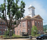
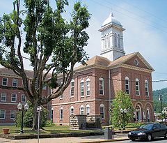
Sutton slowly rebuilt but remained small until the local timber industry boomed. The town then became a commercial center, and many of the banks, hotels, shops, and other historic buildings in the Sutton Downtown Historic District
Sutton Downtown Historic District
Sutton Downtown Historic District is a national historic district located at Sutton, Braxton County, West Virginia. It encompasses 85 contributing buildings and two contributing structures covering eleven square blocks. The district includes the commercial, ecclesiastical, and civic core of the...
date from this 1890–1920 period. After this, Sutton once again slowed in development. Sutton Dam
Sutton Lake
Sutton Lake is a reservoir on the Elk River in Braxton and Webster counties, West Virginia. Sutton Lake is located just upstream of Sutton. It was authorized by Congress in the Flood Control Act of 1938. Construction of the dam began in 1956 and was completed in 1961. The dam is high, long, and...
was built on the Elk River upstream from the town in 1961, adding a tourism component to the local economy.
The William Edgar Haymond House
William Edgar Haymond House
William Edgar Haymond House is a historic home located at Sutton, Braxton County, West Virginia. It was designed in 1894, and is a 2 1/2-story wood frame dwelling in the Queen Anne-style. It sits on a sandstone foundation and features a porch supported by four round Doric order columns...
and Old Sutton High School
Old Sutton High School
Old Sutton High School, also known as Sutton Grade School, is a historic school located at Sutton, Braxton County, West Virginia. It was built in 1906, and is a three story red brick building. It measures 68 feet by 64 feet and features a three story, truncated entrance tower. It houses eight...
are listed on the National Register of Historic Places
National Register of Historic Places
The National Register of Historic Places is the United States government's official list of districts, sites, buildings, structures, and objects deemed worthy of preservation...
, along with the historic district.
Geography
Sutton is located at 38°39′52"N 80°42′37"W (38.664437, -80.710172), along the Elk RiverElk River (West Virginia)
The Elk River is a tributary of the Kanawha River, long, in central West Virginia in the United States. Via the Kanawha and Ohio Rivers, it is part of the watershed of the Mississippi River.-Course:...
.
According to the United States Census Bureau
United States Census Bureau
The United States Census Bureau is the government agency that is responsible for the United States Census. It also gathers other national demographic and economic data...
, the town has a total area of 0.8 square miles (2.1 km²), all land.
The Sutton Lake project was authorized by Congress in the Flood Control Act of 1938. Construction began in October 1949, but was interrupted by the Korean War. Work restarted in 1956 and in the dam was finally completed in 1961. The Dam and lake provide opportunities for boating, picnicing, playgrounds, camping and pavilions available for rent. A handicap-access fishing area was also recently constructed at the Sutton Dam.
2000 Census data
As of the censusCensus
A census is the procedure of systematically acquiring and recording information about the members of a given population. It is a regularly occurring and official count of a particular population. The term is used mostly in connection with national population and housing censuses; other common...
of 2000, there were 1,011 people, 470 households, and 283 families residing in the town. The population density
Population density
Population density is a measurement of population per unit area or unit volume. It is frequently applied to living organisms, and particularly to humans...
was 1,226.9 inhabitants per square mile (476.0/km²). There were 557 housing units at an average density of 675.9 per square mile (262.3/km²). The racial makeup of the town was 97.82% White, 0.49% African American, 0.30% Native American, 0.49% from other races
Race (United States Census)
Race and ethnicity in the United States Census, as defined by the Federal Office of Management and Budget and the United States Census Bureau, are self-identification data items in which residents choose the race or races with which they most closely identify, and indicate whether or not they are...
, and 0.89% from two or more races. Hispanic or Latino of any race were 0.30% of the population.
There were 470 households out of which 22.1% had children under the age of 18 living with them, 43.0% were married couples
Marriage
Marriage is a social union or legal contract between people that creates kinship. It is an institution in which interpersonal relationships, usually intimate and sexual, are acknowledged in a variety of ways, depending on the culture or subculture in which it is found...
living together, 13.6% had a female householder with no husband present, and 39.6% were non-families. 34.9% of all households were made up of individuals and 15.7% had someone living alone who was 65 years of age or older. The average household size was 2.14 and the average family size was 2.69.
In the town the population dispersal was 19.3% under the age of 18, 7.4% from 18 to 24, 22.4% from 25 to 44, 31.6% from 45 to 64, and 19.4% who were 65 years of age or older. The median age was 46 years. For every 100 females there were 86.2 males. For every 100 females age 18 and over, there were 83.8 males. The median income for a household in the town was $25,134, and the median income for a family was $37,679. Males had a median income of $26,875 versus $21,875 for females. The per capita income
Per capita income
Per capita income or income per person is a measure of mean income within an economic aggregate, such as a country or city. It is calculated by taking a measure of all sources of income in the aggregate and dividing it by the total population...
for the town was $15,397. About 19.7% of families and 25.3% of the population were below the poverty line, including 39.8% of those under age 18 and 15.6% of those age 65 or over.