
Supai, Arizona
Encyclopedia
Supai is a census-designated place
(CDP) in Coconino County, Arizona
, United States, within the Grand Canyon
.
As of the 1990 census
, the CDP had a population of 423; the 2000 census erroneously recorded a population of 0. The capital of the Havasupai Indian Reservation, Supai is currently one of only two places in the United States where mail is still carried out by mules, the other being Phantom Ranch
in the Grand Canyon.
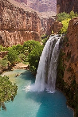
It is also the most remote community in the lower 48 states, and the only way to get to it is to take a helicopter or to hike or ride a mule along the Havasupai Trail
. Supai is eight miles (13 km) from the nearest road. There are no cars in the community.
. More heavy rains were expected and a flash flood warning was put into effect, necessitating the evacuation, according to the Grand Canyon
National Park Service
. The floods were significant enough to attract coverage from international media.
Damage to the trails, bridges, and campground was severe enough for Havasupai to close visitor access to the village, campground, and falls until the spring of 2009.
Further flooding in 2010 resulted in damage to repairs made previously and closures effective until May 2011. Those returning will find yet more changes to the once familiar landmarks near the water.
, Supai is only accessible by foot, pack animal or helicopter
. Mail and package delivery to the community is thus delayed; delivery time for mail from Bullhead City, Arizona
, via the United States Postal Service
is at least a week because it is carried out by mule (D. Varty, personal communication, 2004).
According to the United States Census Bureau
, the CDP has a total area of 1.7 square miles (4.4 km²), all land. It lies 3,195 feet (974 m) above sea level.
, 4.96% White
, and 0.47% Asian
. 0.95% of the population were Hispanic
or Latino
of any race.
There were 104 households out of which 60.6% were married couples living together, 16.3% had a female householder with no husband present, and 15.4% were non-families. 10.6% of all households were made up of individuals and 1.9% had someone living alone who was 65 years of age or older. The average household size was 4.07.
In the CDP the age distribution of the population shows 39.4% under the age of 18, 8.0% from 18 to 24, 33.6% from 25 to 44, 12.5% from 45 to 64, and 5.7% who are 65 years of age or older. For every 100 males there were 98.6 females. For every 100 males age 18 and over, there were 87.4 females.
through the Hualapai Canyon, and the AirWest Helicopters service schedules flights from Hualapai Hilltop to Supai. Hualapai Hilltop is located about 70 miles (112.7 km) from the community of Peach Springs
, along paved BIA Road 18.
).
All mail leaving Supai has a special postmark showing that it was sent out by mule train.
Census-designated place
A census-designated place is a concentration of population identified by the United States Census Bureau for statistical purposes. CDPs are delineated for each decennial census as the statistical counterparts of incorporated places such as cities, towns and villages...
(CDP) in Coconino County, Arizona
Coconino County, Arizona
-2010:Whereas according to the 2010 U.S. Census Bureau:*61.7% White*1.2% Black*27.3% Native American*1.4% Asian*0.1% Native Hawaiian or Pacific Islander*3.1% Two or more races*5.2% Other races*13.5% Hispanic or Latino -2000:...
, United States, within the Grand Canyon
Grand Canyon
The Grand Canyon is a steep-sided canyon carved by the Colorado River in the United States in the state of Arizona. It is largely contained within the Grand Canyon National Park, the 15th national park in the United States...
.
As of the 1990 census
United States Census, 1990
The Twenty-first United States Census, conducted by the Census Bureau, determined the resident population of the United States to be 248,709,873, an increase of 9.8 percent over the 226,545,805 persons enumerated during the 1980 Census....
, the CDP had a population of 423; the 2000 census erroneously recorded a population of 0. The capital of the Havasupai Indian Reservation, Supai is currently one of only two places in the United States where mail is still carried out by mules, the other being Phantom Ranch
Phantom Ranch
Phantom Ranch is a resort village within Grand Canyon National Park in Arizona. It is located on the north side of the Colorado River near its confluence with Bright Angel Creek and Phantom Creek.-History:...
in the Grand Canyon.
It is also the most remote community in the lower 48 states, and the only way to get to it is to take a helicopter or to hike or ride a mule along the Havasupai Trail
Havasupai Trail
Havasupai Trail is the main trail to Supai, Arizona and to Havasu Falls.-Trail:The trailhead is located at Hualapai Hilltop , where there is a large parking lot, a heli-pad, portable toilets, and the main office for the Havasupai. The trail can be traveled by foot, by horseback, or on a mule...
. Supai is eight miles (13 km) from the nearest road. There are no cars in the community.
Recent history
Tourists and some residents were evacuated from Supai and surrounding area on August 17th and 18th, 2008 due to flooding complicated by the failure of the earthen Redlands Dam after a night of heavy rainfall. Evacuees were taken to Peach Springs, ArizonaPeach Springs, Arizona
Peach Springs is a census-designated place in Mohave County, Arizona, United States. The population was 600 at the 2000 census. Peach Springs serves as the administrative headquarters of the Hualapai people, and is located on the Hualapai Reservation.-Geography:Peach Springs is located at ...
. More heavy rains were expected and a flash flood warning was put into effect, necessitating the evacuation, according to the Grand Canyon
Grand Canyon
The Grand Canyon is a steep-sided canyon carved by the Colorado River in the United States in the state of Arizona. It is largely contained within the Grand Canyon National Park, the 15th national park in the United States...
National Park Service
National Park Service
The National Park Service is the U.S. federal agency that manages all national parks, many national monuments, and other conservation and historical properties with various title designations...
. The floods were significant enough to attract coverage from international media.
Damage to the trails, bridges, and campground was severe enough for Havasupai to close visitor access to the village, campground, and falls until the spring of 2009.
Further flooding in 2010 resulted in damage to repairs made previously and closures effective until May 2011. Those returning will find yet more changes to the once familiar landmarks near the water.
Geography
Located within the Grand CanyonGrand Canyon
The Grand Canyon is a steep-sided canyon carved by the Colorado River in the United States in the state of Arizona. It is largely contained within the Grand Canyon National Park, the 15th national park in the United States...
, Supai is only accessible by foot, pack animal or helicopter
Helicopter
A helicopter is a type of rotorcraft in which lift and thrust are supplied by one or more engine-driven rotors. This allows the helicopter to take off and land vertically, to hover, and to fly forwards, backwards, and laterally...
. Mail and package delivery to the community is thus delayed; delivery time for mail from Bullhead City, Arizona
Bullhead City, Arizona
Bullhead City is a city located on the Colorado River in Mohave County, Arizona, USA, roughly south of Las Vegas, Nevada, and directly across the Colorado River from Laughlin, Nevada, whose casinos and ancillary services supply much of the employment for Bullhead City...
, via the United States Postal Service
United States Postal Service
The United States Postal Service is an independent agency of the United States government responsible for providing postal service in the United States...
is at least a week because it is carried out by mule (D. Varty, personal communication, 2004).
According to the United States Census Bureau
United States Census Bureau
The United States Census Bureau is the government agency that is responsible for the United States Census. It also gathers other national demographic and economic data...
, the CDP has a total area of 1.7 square miles (4.4 km²), all land. It lies 3,195 feet (974 m) above sea level.
Demographics
As of the 1990 census, there were 423 people, 104 households, and 88 families residing in the CDP. The population density was 248.8 people per square mile (94.0/km²). There were 136 housing units at an average density of 80.0 per square mile (30.2/km²). The racial makeup of the CDP was 94.56% Native AmericanRace (United States Census)
Race and ethnicity in the United States Census, as defined by the Federal Office of Management and Budget and the United States Census Bureau, are self-identification data items in which residents choose the race or races with which they most closely identify, and indicate whether or not they are...
, 4.96% White
Race (United States Census)
Race and ethnicity in the United States Census, as defined by the Federal Office of Management and Budget and the United States Census Bureau, are self-identification data items in which residents choose the race or races with which they most closely identify, and indicate whether or not they are...
, and 0.47% Asian
Race (United States Census)
Race and ethnicity in the United States Census, as defined by the Federal Office of Management and Budget and the United States Census Bureau, are self-identification data items in which residents choose the race or races with which they most closely identify, and indicate whether or not they are...
. 0.95% of the population were Hispanic
Race (United States Census)
Race and ethnicity in the United States Census, as defined by the Federal Office of Management and Budget and the United States Census Bureau, are self-identification data items in which residents choose the race or races with which they most closely identify, and indicate whether or not they are...
or Latino
Race (United States Census)
Race and ethnicity in the United States Census, as defined by the Federal Office of Management and Budget and the United States Census Bureau, are self-identification data items in which residents choose the race or races with which they most closely identify, and indicate whether or not they are...
of any race.
There were 104 households out of which 60.6% were married couples living together, 16.3% had a female householder with no husband present, and 15.4% were non-families. 10.6% of all households were made up of individuals and 1.9% had someone living alone who was 65 years of age or older. The average household size was 4.07.
In the CDP the age distribution of the population shows 39.4% under the age of 18, 8.0% from 18 to 24, 33.6% from 25 to 44, 12.5% from 45 to 64, and 5.7% who are 65 years of age or older. For every 100 males there were 98.6 females. For every 100 males age 18 and over, there were 87.4 females.
Access
Supai can be reached by hiking eight miles (13 km), descending 3,000 vertical feet (900 meters) from Hualapai HilltopHualapai Hilltop, Arizona
Hualapai Hilltop is the location of the trailhead that leads down into Supai, Arizona. At some point in the past, the rim area was inhabited by the Havasupai people, who moved seasonally between the canyon floor and the rim, but they were forced to stay in the canyon by the Bureau of Indian...
through the Hualapai Canyon, and the AirWest Helicopters service schedules flights from Hualapai Hilltop to Supai. Hualapai Hilltop is located about 70 miles (112.7 km) from the community of Peach Springs
Peach Springs, Arizona
Peach Springs is a census-designated place in Mohave County, Arizona, United States. The population was 600 at the 2000 census. Peach Springs serves as the administrative headquarters of the Hualapai people, and is located on the Hualapai Reservation.-Geography:Peach Springs is located at ...
, along paved BIA Road 18.
Services
Supai has one small, air-conditioned lodge (Havasupai Lodge), a convenience store, and one cafe serving fast food meals (most utilizing frybreadFrybread
Frybread is a Native American food found throughout the United States. Frybread is a flat dough fried or deep-fried in oil, shortening, or lard. The dough is generally leavened by yeast or baking powder....
).
All mail leaving Supai has a special postmark showing that it was sent out by mule train.