
Stoughton, West Sussex
Encyclopedia
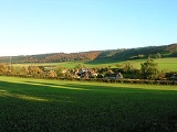
Stoughton is a village and civil parish
in the District of Chichester
in West Sussex
, England
located nine kilometres (5.5 miles) north west of Chichester
east of the B2146 road, on a lane leading to East Marden
.
The parish has a land area of 2987 hectares (7156 acres). In the 2001 census 631 people lived in 255 households, of whom 286 were economically active. The parish is crossed from west to east by the Monarch's Way
long distance footpath, which passes through the villages of Stoughton and Walderton
. There is one pub, The Hare and Hounds.
Famous 19th century cricket
er George Brown
was born in the village.
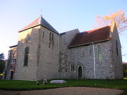 The church, standing on a hillside overlooking the village, is of late Saxon or early Norman origin.
and a National Nature Reserve
. It is noted for its Yew woodlands. The site is also known for its archaeological interest including the Bronze Age barrow cemetery known as the Devil's Humps
, Bronze Age and Roman earthworks, cross dykes, a camp and a field system.
Civil parish
In England, a civil parish is a territorial designation and, where they are found, the lowest tier of local government below districts and counties...
in the District of Chichester
Chichester (district)
Chichester is a largely rural local government district in West Sussex, England. Its council is based in the city of Chichester.-History:The district was formed on 1 April 1974, under the Local Government Act 1972, as a merger of the municipal borough of Chichester and the Rural Districts of...
in West Sussex
West Sussex
West Sussex is a county in the south of England, bordering onto East Sussex , Hampshire and Surrey. The county of Sussex has been divided into East and West since the 12th century, and obtained separate county councils in 1888, but it remained a single ceremonial county until 1974 and the coming...
, England
England
England is a country that is part of the United Kingdom. It shares land borders with Scotland to the north and Wales to the west; the Irish Sea is to the north west, the Celtic Sea to the south west, with the North Sea to the east and the English Channel to the south separating it from continental...
located nine kilometres (5.5 miles) north west of Chichester
Chichester
Chichester is a cathedral city in West Sussex, within the historic County of Sussex, South-East England. It has a long history as a settlement; its Roman past and its subsequent importance in Anglo-Saxon times are only its beginnings...
east of the B2146 road, on a lane leading to East Marden
East Marden
East Marden is a village on the spur of the South Downs in the Chichester district of West Sussex, England. It is within the civil parish of Marden, West Sussex. It is first mentioned in the Domesday Book as Meredone and was given in 1086 to Roger, Earl of Montgomery...
.
The parish has a land area of 2987 hectares (7156 acres). In the 2001 census 631 people lived in 255 households, of whom 286 were economically active. The parish is crossed from west to east by the Monarch's Way
Monarch's Way
The Monarch's Way is a long-distance footpath in England that approximates the escape route taken by King Charles II in 1651 after being defeated in the Battle of Worcester.Most of the footpath is waymarked...
long distance footpath, which passes through the villages of Stoughton and Walderton
Walderton
Walderton is a hamlet in the Chichester district of West Sussex, England. It lies on the B2146 road 4 miles northeast of Emsworth....
. There is one pub, The Hare and Hounds.
Famous 19th century cricket
Cricket
Cricket is a bat-and-ball game played between two teams of 11 players on an oval-shaped field, at the centre of which is a rectangular 22-yard long pitch. One team bats, trying to score as many runs as possible while the other team bowls and fields, trying to dismiss the batsmen and thus limit the...
er George Brown
George Brown (Sussex cricketer)
George Brown was an English professional cricketer who played first-class cricket from 1819 to 1838....
was born in the village.
The parish church
Landmarks
Kingley Vale lies on the border of the parish which is a Site of Special Scientific InterestSite of Special Scientific Interest
A Site of Special Scientific Interest is a conservation designation denoting a protected area in the United Kingdom. SSSIs are the basic building block of site-based nature conservation legislation and most other legal nature/geological conservation designations in Great Britain are based upon...
and a National Nature Reserve
National Nature Reserve
For details of National nature reserves in the United Kingdom see:*National Nature Reserves in England*National Nature Reserves in Northern Ireland*National Nature Reserves in Scotland*National Nature Reserves in Wales...
. It is noted for its Yew woodlands. The site is also known for its archaeological interest including the Bronze Age barrow cemetery known as the Devil's Humps
Devil's Humps, Stoughton
The Devil's Humps are four Bronze Age barrows situated on Bow Hill on the South Downs near Stoughton, West Sussex. They are situated on a downland ridgeway crossed by an ancient trackway, above Kingley Vale. The Devil's Humps are counted among the most impressive round barrows surviving on the...
, Bronze Age and Roman earthworks, cross dykes, a camp and a field system.