

Stewart, British Columbia
Encyclopedia
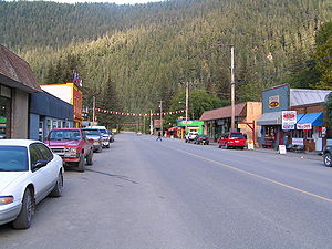
Stewart is a small town, incorporated as a district municipality
at the head of the Portland Canal
in northwestern British Columbia
, Canada
. In 2006, its population was about 496.
 The Nisga'a
, who lived around the Nass River
, called the head of Portland Canal Skam-A-Kounst, meaning "safe house" or "strong house", probably because it served them as a retreat from the harassment of the Haida and Tlingit from the outer coast. They travelled in the area seasonally to pick berries and hunt birds. It and the rest of the Portland Canal had been the domain of the Tsetsaut people, also called the Skam-a-Kounst Indians, or Jits'aawit in Nisga'a
, an Athapaskan people who became decimated by war and disease and were driven out of the Stewart area by either Haida or Nisga'a in 1856-57.
The area around the Portland Canal was explored in 1896 by Captain D.D. Gaillard of the United States Army Corps of Engineers
(after whom the Gaillard Cut in the Panama Canal was later named). Two years after Gaillard's visit, the first prospectors and settlers arrived. Among them was D. J. Raine, for whom a creek and a mountain in the area are named. The Stewart brothers arrived in 1902. In 1905, Robert M. Stewart, the first postmaster, named the town Stewart.
Gold
and silver
mining dominated the early economy. Nearby Hyder
, Alaska
, boomed with the discovery of rich silver veins in the upper Salmon River basin in 1917 and 1918. Hyder became an access and supply point for the mines, while Stewart served as the port for Canadian mining activity, which was centred on the town of Premier
, which was accessed by a 14 miles (22.5 km) road from Hyder.
Other mines in the area were the Jumbo, BC Silver, Red Cliff, and Porter-Idaho. More large camps were south of Stewart at Anyox and Maple Bay.
Stewart had a population of about 10,000 prior to World War I
, which then declined to about 700 in 2000. As of 2005, its population had reduced to less than 500.
.
West of Stewart is Hyder, Alaska, which is only 3 kilometres (1.86 mi) from the town. East of the town is Meziadin Junction, which is 65 kilometres (40.4 mi) from the town. Also east is Kitwanga, British Columbia
, which is located 221 kilometres (137.3 mi) from the town, and Dease Lake, British Columbia
, which is located 398 kilometres (247.3 mi) north of Stewart.
District municipality
A district municipality is a designation for a class of municipalities found in several locations, including Canada, Lithuania, and South Africa.-Usage in British Columbia:...
at the head of the Portland Canal
Portland Canal
The Portland Canal is an arm of Portland Inlet, one of the principal inlets of the British Columbia Coast. It is approximately long. The Portland Canal forms part of the border between southeastern Alaska and British Columbia. The name of the entire inlet in the Nisga'a language is K'alii...
in northwestern British Columbia
British Columbia
British Columbia is the westernmost of Canada's provinces and is known for its natural beauty, as reflected in its Latin motto, Splendor sine occasu . Its name was chosen by Queen Victoria in 1858...
, Canada
Canada
Canada is a North American country consisting of ten provinces and three territories. Located in the northern part of the continent, it extends from the Atlantic Ocean in the east to the Pacific Ocean in the west, and northward into the Arctic Ocean...
. In 2006, its population was about 496.
History
Nisga'a
The Nisga’a , often formerly spelled Nishga and spelled in the Nisga’a language as Nisga’a, are an Indigenous nation or First Nation in Canada. They live in the Nass River valley of northwestern British Columbia. Their name comes from a combination of two Nisga’a words: Nisk’-"top lip" and...
, who lived around the Nass River
Nass River
The Nass River is a river in northern British Columbia, Canada. It flows from the Coast Mountains southwest to Nass Bay, a sidewater of Portland Inlet, which connects to the North Pacific Ocean via the Dixon Entrance...
, called the head of Portland Canal Skam-A-Kounst, meaning "safe house" or "strong house", probably because it served them as a retreat from the harassment of the Haida and Tlingit from the outer coast. They travelled in the area seasonally to pick berries and hunt birds. It and the rest of the Portland Canal had been the domain of the Tsetsaut people, also called the Skam-a-Kounst Indians, or Jits'aawit in Nisga'a
Nisga'a language
Nisga’a is a Tsimshianic language of the Nisga'a people of northwestern British Columbia. Nisga'a people, however, do not like the term Tshimshianic as they feel that it gives precedence to Coast Tsimshian. Nisga’a is very closely related to Gitksan...
, an Athapaskan people who became decimated by war and disease and were driven out of the Stewart area by either Haida or Nisga'a in 1856-57.
The area around the Portland Canal was explored in 1896 by Captain D.D. Gaillard of the United States Army Corps of Engineers
United States Army Corps of Engineers
The United States Army Corps of Engineers is a federal agency and a major Army command made up of some 38,000 civilian and military personnel, making it the world's largest public engineering, design and construction management agency...
(after whom the Gaillard Cut in the Panama Canal was later named). Two years after Gaillard's visit, the first prospectors and settlers arrived. Among them was D. J. Raine, for whom a creek and a mountain in the area are named. The Stewart brothers arrived in 1902. In 1905, Robert M. Stewart, the first postmaster, named the town Stewart.
Gold
Gold
Gold is a chemical element with the symbol Au and an atomic number of 79. Gold is a dense, soft, shiny, malleable and ductile metal. Pure gold has a bright yellow color and luster traditionally considered attractive, which it maintains without oxidizing in air or water. Chemically, gold is a...
and silver
Silver
Silver is a metallic chemical element with the chemical symbol Ag and atomic number 47. A soft, white, lustrous transition metal, it has the highest electrical conductivity of any element and the highest thermal conductivity of any metal...
mining dominated the early economy. Nearby Hyder
Hyder, Alaska
Hyder is a census-designated place in Prince of Wales-Hyder Census Area, Alaska, United States. At the 2000 census the population was 97. Hyder has achieved fame as a point in Alaska accessible to automobile and motorbike travelers in Canada who want to say that they have been to Alaska...
, Alaska
Alaska
Alaska is the largest state in the United States by area. It is situated in the northwest extremity of the North American continent, with Canada to the east, the Arctic Ocean to the north, and the Pacific Ocean to the west and south, with Russia further west across the Bering Strait...
, boomed with the discovery of rich silver veins in the upper Salmon River basin in 1917 and 1918. Hyder became an access and supply point for the mines, while Stewart served as the port for Canadian mining activity, which was centred on the town of Premier
Premier, British Columbia
Premier was a large gold mining camp in British Columbia, Canada some 18 miles from Stewart. It ran from the years 1918 to 1953 and was a large employer in the area. Huge bunkhouses, generators, concentrators, machine and cook houses sat on the hillside. A road provided access to the area, snowfall...
, which was accessed by a 14 miles (22.5 km) road from Hyder.
Other mines in the area were the Jumbo, BC Silver, Red Cliff, and Porter-Idaho. More large camps were south of Stewart at Anyox and Maple Bay.
Stewart had a population of about 10,000 prior to World War I
World War I
World War I , which was predominantly called the World War or the Great War from its occurrence until 1939, and the First World War or World War I thereafter, was a major war centred in Europe that began on 28 July 1914 and lasted until 11 November 1918...
, which then declined to about 700 in 2000. As of 2005, its population had reduced to less than 500.
Location
Stewart is accessible by highway from the British Columbia highway system, via Highway 37ABritish Columbia Highway 37A
-Highway 37A:Highway 37A, the Stewart Highway, also known as the Glacier Highway, is a 65 km long spur off of Highway 37 west to the border towns of Stewart and Hyder, Alaska, where it connects with Alaska's Salmon River Road...
.
West of Stewart is Hyder, Alaska, which is only 3 kilometres (1.86 mi) from the town. East of the town is Meziadin Junction, which is 65 kilometres (40.4 mi) from the town. Also east is Kitwanga, British Columbia
Kitwanga, British Columbia
Kitwanga or Gitwangax is located where the Kitwanga River runs into the Skeena River in British Columbia. A long-standing village before Contact, the village is within Gitwangak Indian Reserve No...
, which is located 221 kilometres (137.3 mi) from the town, and Dease Lake, British Columbia
Dease Lake, British Columbia
Dease Lake is a small community located in the Cassiar Country of the Northern Interior of British Columbia, Canada. Located only a few hours south of the Yukon border, it is located on Highway 37 at the south end of the lake of the same name. Dease Lake is the last major centre before the Alaska...
, which is located 398 kilometres (247.3 mi) north of Stewart.