

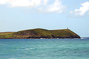
Stepper Point
Encyclopedia
Headlands and bays
Headlands and bays are two related features of the coastal environment.- Geology and geography :Headlands and bays are often found on the same coastline. A bay is surrounded by land on three sides, whereas a headland is surrounded by water on three sides. Headlands are characterized by high,...
on the Atlantic
Atlantic Ocean
The Atlantic Ocean is the second-largest of the world's oceanic divisions. With a total area of about , it covers approximately 20% of the Earth's surface and about 26% of its water surface area...
coast in north Cornwall
Cornwall
Cornwall is a unitary authority and ceremonial county of England, within the United Kingdom. It is bordered to the north and west by the Celtic Sea, to the south by the English Channel, and to the east by the county of Devon, over the River Tamar. Cornwall has a population of , and covers an area of...
, England
England
England is a country that is part of the United Kingdom. It shares land borders with Scotland to the north and Wales to the west; the Irish Sea is to the north west, the Celtic Sea to the south west, with the North Sea to the east and the English Channel to the south separating it from continental...
, UK.
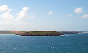
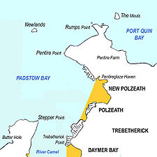
Stepper Point and Pentire Point
Pentire Point
Pentire Head is a headland and peninsula on the Atlantic coast in North Cornwall, England, UK and is approx one mile square. The headland projects north-west with Pentire Point at its north-west corner and The Rumps promontory at its north-east corner....
stand at either side of the mouth of the River Camel
River Camel
The River Camel is a river in Cornwall, UK. It rises on the edge of Bodmin Moor and together with its tributaries drains a considerable part of North Cornwall. The river issues into the Celtic Sea area of the Atlantic Ocean between Stepper Point and Pentire Point having covered a distance of...
; Stepper to the south-west, Pentire to the north-east.
The headland above Stepper Point is topped by a stone tower, built as a 'day mark' to serve as a navigation beacon for seafarers during daylight. It is referred to locally as the Daymark. There is also a coastguard lookout building on the headland. This is reached by a metalled road from the tiny hamlet of Crugmeer
Crugmeer
Crugmeer is a hamlet in north Cornwall, United Kingdom. It is situated one-and-a-half miles from Padstow to the west of the River Camel estuary....
but vehicle access is restricted.
The South West Coast Path
South West Coast Path
The South West Coast Path is Britain's longest waymarked long-distance footpath and a National Trail. It stretches for , running from Minehead in Somerset, along the coasts of Devon and Cornwall, to Poole Harbour in Dorset. Since it rises and falls with every river mouth, it is also one of the more...
closely follows the coastline of the headland. The three-mile (5 km) stretch of coast path from Padstow
Padstow
Padstow is a town, civil parish and fishing port on the north coast of Cornwall, England, United Kingdom. The town is situated on the west bank of the River Camel estuary approximately five miles northwest of Wadebridge, ten miles northwest of Bodmin and ten miles northeast of Newquay...
to Stepper Point has fairly easy gradients and is well-surfaced; beyond Stepper towards Trevone, the path becomes rougher and more sharply graded.
Sightseeing boat tours regularly travel along the coast from the nearby port of Padstow
Padstow
Padstow is a town, civil parish and fishing port on the north coast of Cornwall, England, United Kingdom. The town is situated on the west bank of the River Camel estuary approximately five miles northwest of Wadebridge, ten miles northwest of Bodmin and ten miles northeast of Newquay...
.
Geography
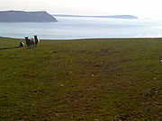
The headland rises to 242 feet (74 m) at its highest point. The land is used for farming and the remains of several defunct stone quarries can be seen.The coast to the east of Stepper Point is on the estuary of the River Camel. This side of the headland boasts the sandhills of Tregirls beach and St George's cove (which is easily accessed from the coast path). A little further north, Harbour Cove and Hawker's Cove
Hawker's Cove, Cornwall
Hawker's Cove is a small coastal settlement in north Cornwall, United Kingdom. It is situated one-and-a-half miles north of Padstow on the west side of the River Camel estuary....
(where the Padstow lifeboat
Padstow lifeboat
Padstow lifeboat Station is based at Trevose Head west of Padstow. The current coxswain is Alan Tarby. The current lifeboat is a Tamar class boat called "Spirit of Padstow".- Hawker's Cove Station:...
was stationed until 1967) are connected at low water by an extensive sandy beach which forms part of a sandbank at the mouth of the estuary known as Doom Bar
Doom Bar
The Doom Bar is a bank of sand at the estuary of the River Camel where it meets the Celtic Sea on Cornwall's north coast. It represents a significant hazard to shipping, and there have been many ships wrecked there through the centuries...
.
To the south-west of the headland, the coastal scenery is more rugged with cliffs rising above a rocky foreshore. A mile south of Stepper point is another small headland called Gunver Head and a further mile on is the small sandy beach at Trevone.
Due to its important geological features Stepper Point was designated a Site of Special Scientific Interest
Site of Special Scientific Interest
A Site of Special Scientific Interest is a conservation designation denoting a protected area in the United Kingdom. SSSIs are the basic building block of site-based nature conservation legislation and most other legal nature/geological conservation designations in Great Britain are based upon...
in 1990.