
Stateburg, South Carolina
Encyclopedia
Stateburg is a census-designated place
(CDP) in the High Hills of Santee
in Sumter County, South Carolina
, United States
. The population was 1,264 at the 2000 census
. It is included in the Sumter, South Carolina
Metropolitan Statistical Area. Stateburg is located within the larger Stateburg Historic District
.
In the 1780s, after the South Carolina General Assembly
decided to move the state capital from Charleston
to the central part of the state, Stateburg lost by only a few votes to a place called Granby's Ferry on the Congaree River
near the confluence of the Broad
and Saluda
rivers. Granby's Ferry soon was renamed Columbia
, which is still the capital.
According to the United States Census Bureau
, the CDP has a total area of 4.7 square miles (12.2 km²), of which, 4.7 square miles (12.1 km²) of it is land and 0.04 square miles (0.1 km²) of it (0.43%) is water.
of 2000, there were 1,264 people, 461 households, and 389 families residing in the CDP. The population density
was 270.3 people per square mile (104.3/km²). There were 477 housing units at an average density of 102.0/sq mi (39.4/km²). The racial makeup of the CDP was 72.55% White, 22.71% African American, 0.55% Native American, 2.06% Asian, 0.08% Pacific Islander, 0.32% from other races
, and 1.74% from two or more races. Hispanic or Latino of any race were 2.69% of the population.
There were 461 households out of which 38.6% had children under the age of 18 living with them, 73.5% were married couples
living together, 6.5% had a female householder with no husband present, and 15.6% were non-families. 13.2% of all households were made up of individuals and 2.2% had someone living alone who was 65 years of age or older. The average household size was 2.74 and the average family size was 2.99.
In the CDP the population was spread out with 26.8% under the age of 18, 6.6% from 18 to 24, 30.1% from 25 to 44, 29.9% from 45 to 64, and 6.6% who were 65 years of age or older. The median age was 38 years. For every 100 females there were 98.7 males. For every 100 females age 18 and over, there were 96.4 males.
The median income for a household in the CDP was $59,152, and the median income for a family was $59,196. Males had a median income of $42,431 versus $26,875 for females. The per capita income
for the CDP was $23,617. None of the families and 1.2% of the population were living below the poverty line, including no under eighteens and 7.9% of those over 64.
Census-designated place
A census-designated place is a concentration of population identified by the United States Census Bureau for statistical purposes. CDPs are delineated for each decennial census as the statistical counterparts of incorporated places such as cities, towns and villages...
(CDP) in the High Hills of Santee
High Hills of Santee
The High Hills of Santee, sometimes known as the High Hills of the Santee, is a long, narrow hilly region in the western part of Sumter County, South Carolina. It has been called "one of the state's most famous areas". The High Hills of Santee region lies north of the Santee River and east of the...
in Sumter County, South Carolina
South Carolina
South Carolina is a state in the Deep South of the United States that borders Georgia to the south, North Carolina to the north, and the Atlantic Ocean to the east. Originally part of the Province of Carolina, the Province of South Carolina was one of the 13 colonies that declared independence...
, United States
United States
The United States of America is a federal constitutional republic comprising fifty states and a federal district...
. The population was 1,264 at the 2000 census
United States Census, 2000
The Twenty-second United States Census, known as Census 2000 and conducted by the Census Bureau, determined the resident population of the United States on April 1, 2000, to be 281,421,906, an increase of 13.2% over the 248,709,873 persons enumerated during the 1990 Census...
. It is included in the Sumter, South Carolina
Sumter, South Carolina
-Demographics:, there were 59,180 people, 34,717 households, and 4,049 families living in the city. The population density was 4,469.5 people per square mile . There were 416,032 housing units at an average density of 603.0 per square mile...
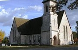
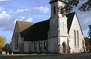
Metropolitan Statistical Area. Stateburg is located within the larger Stateburg Historic District
Stateburg Historic District
The Stateburg Historic District is a historic district in Stateburg, in the High Hills of Santee area near Sumter,South Carolina in the United States. It includes two National Historic Landmarks, Borough House Plantation and the Church of the Holy Cross, and at least eight contributing properties...
.
In the 1780s, after the South Carolina General Assembly
South Carolina General Assembly
The South Carolina General Assembly, also called the South Carolina Legislature, is the state legislature of the U.S. state of South Carolina. The legislature is bicameral and consists of the lower South Carolina House of Representatives and the upper South Carolina Senate. Altogether, the General...
decided to move the state capital from Charleston
Charleston, South Carolina
Charleston is the second largest city in the U.S. state of South Carolina. It was made the county seat of Charleston County in 1901 when Charleston County was founded. The city's original name was Charles Towne in 1670, and it moved to its present location from a location on the west bank of the...
to the central part of the state, Stateburg lost by only a few votes to a place called Granby's Ferry on the Congaree River
Congaree River
The Congaree River is a short but wide river in South Carolina in the United States; It flows for only 47 miles . The river serves an important role as the final outlet channel for the entire Lower Saluda and Lower Broad watersheds, before merging with the Wateree River just north of Lake Marion to...
near the confluence of the Broad
Broad River (Carolinas)
The Broad River is a principal tributary of the Congaree River, about 150 miles long, in western North Carolina and northern South Carolina in the United States. Via the Congaree, it is part of the watershed of the Santee River, which flows to the Atlantic Ocean...
and Saluda
Saluda River
The Saluda River is a principal tributary of the Congaree River, about 200 mi long, in northern and western South Carolina in the United States...
rivers. Granby's Ferry soon was renamed Columbia
Columbia, South Carolina
Columbia is the state capital and largest city in the U.S. state of South Carolina. The population was 129,272 according to the 2010 census. Columbia is the county seat of Richland County, but a portion of the city extends into neighboring Lexington County. The city is the center of a metropolitan...
, which is still the capital.
Geography
Stateburg is located at 33°58′43"N 80°31′30"W (33.978524, -80.524951).According to the United States Census Bureau
United States Census Bureau
The United States Census Bureau is the government agency that is responsible for the United States Census. It also gathers other national demographic and economic data...
, the CDP has a total area of 4.7 square miles (12.2 km²), of which, 4.7 square miles (12.1 km²) of it is land and 0.04 square miles (0.1 km²) of it (0.43%) is water.
Demographics
As of the censusCensus
A census is the procedure of systematically acquiring and recording information about the members of a given population. It is a regularly occurring and official count of a particular population. The term is used mostly in connection with national population and housing censuses; other common...
of 2000, there were 1,264 people, 461 households, and 389 families residing in the CDP. The population density
Population density
Population density is a measurement of population per unit area or unit volume. It is frequently applied to living organisms, and particularly to humans...
was 270.3 people per square mile (104.3/km²). There were 477 housing units at an average density of 102.0/sq mi (39.4/km²). The racial makeup of the CDP was 72.55% White, 22.71% African American, 0.55% Native American, 2.06% Asian, 0.08% Pacific Islander, 0.32% from other races
Race (United States Census)
Race and ethnicity in the United States Census, as defined by the Federal Office of Management and Budget and the United States Census Bureau, are self-identification data items in which residents choose the race or races with which they most closely identify, and indicate whether or not they are...
, and 1.74% from two or more races. Hispanic or Latino of any race were 2.69% of the population.
There were 461 households out of which 38.6% had children under the age of 18 living with them, 73.5% were married couples
Marriage
Marriage is a social union or legal contract between people that creates kinship. It is an institution in which interpersonal relationships, usually intimate and sexual, are acknowledged in a variety of ways, depending on the culture or subculture in which it is found...
living together, 6.5% had a female householder with no husband present, and 15.6% were non-families. 13.2% of all households were made up of individuals and 2.2% had someone living alone who was 65 years of age or older. The average household size was 2.74 and the average family size was 2.99.
In the CDP the population was spread out with 26.8% under the age of 18, 6.6% from 18 to 24, 30.1% from 25 to 44, 29.9% from 45 to 64, and 6.6% who were 65 years of age or older. The median age was 38 years. For every 100 females there were 98.7 males. For every 100 females age 18 and over, there were 96.4 males.
The median income for a household in the CDP was $59,152, and the median income for a family was $59,196. Males had a median income of $42,431 versus $26,875 for females. The per capita income
Per capita income
Per capita income or income per person is a measure of mean income within an economic aggregate, such as a country or city. It is calculated by taking a measure of all sources of income in the aggregate and dividing it by the total population...
for the CDP was $23,617. None of the families and 1.2% of the population were living below the poverty line, including no under eighteens and 7.9% of those over 64.
Notable residents
- Richard H. AndersonRichard H. AndersonRichard Heron Anderson was a career U.S. Army officer, fighting with distinction in the Mexican-American War. He also served as a Confederate general during the American Civil War, fighting in the Eastern Theater of the conflict and most notably during the 1864 Battle of Spotsylvania Court House...
, born in Stateburg, Confederate Army general - Mary Boykin ChesnutMary Boykin ChesnutMary Boykin Chesnut, born Mary Boykin Miller , was a South Carolina author noted for a book published as her Civil War diary, a "vivid picture of a society in the throes of its life-and-death struggle." She described the war from within her upper-class circles of Southern planter society, but...
, born in Stateburg, daughter of Stephen Decatur MillerStephen Decatur MillerStephen Decatur Miller was an American politician, who served as the 52nd Governor of South Carolina from 1828 to 1830. He represented South Carolina as a U.S. Representative from 1817 to 1819, and as a U.S. Senator from 1831 to 1833.He was born in Waxhaw settlement, South Carolina and graduated...
. Her noted diary chronicled life in the South during the Civil War. - Stephen Decatur MillerStephen Decatur MillerStephen Decatur Miller was an American politician, who served as the 52nd Governor of South Carolina from 1828 to 1830. He represented South Carolina as a U.S. Representative from 1817 to 1819, and as a U.S. Senator from 1831 to 1833.He was born in Waxhaw settlement, South Carolina and graduated...
, U.S. Congressman, state Governor, and U.S. Senator - Thomas SumterThomas SumterThomas Sumter nicknamed the "Carolina Gamecock" , was a hero of the American Revolution and went on to become a longtime member of the Congress of the United States.-Early life:Thomas Sumter was born near Charlottesville in Hanover County, Virginia in 1734...
, American Revolutionary WarAmerican Revolutionary WarThe American Revolutionary War , the American War of Independence, or simply the Revolutionary War, began as a war between the Kingdom of Great Britain and thirteen British colonies in North America, and ended in a global war between several European great powers.The war was the result of the...
general.