
.gif)
State Route 77 (Maine)
Encyclopedia
State Route 77 is a state highway in Cumberland County
, Maine
. It connects the cities of Portland
and Scarborough, covering an approximate distance of 12 miles (19.3 km).
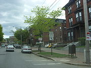 Route 77 starts at Park Avenue, Formerly U.S. Route 1
, in Portland and continues through downtown Portland, over the Casco Bay Bridge
, through South Portland
and Cape Elizabeth
into Scarborough, where it eventually ends at Maine State Route 207. The route is known as a particularly scenic route in the region as a long stretch of the road going through Cape Elizabeth hugs the shoreline with views of the ocean and marshlands. Many local people use Route 77 for jogging/walking and biking because of the scenery and for its relatively flat terrain. The route also is a significant part of the Beach to Beacon
road race which attracts thousands of runners each August, including notable international competitors.
Cumberland County, Maine
Cumberland County is a county located in the U.S. state of Maine. As of 2010, the population was 281,674. Its county seat is Portland, and is the most populous of the sixteen Maine counties, as well as the most affluent. Cumberland County has the deepest and second largest body of water in the...
, Maine
Maine
Maine is a state in the New England region of the northeastern United States, bordered by the Atlantic Ocean to the east and south, New Hampshire to the west, and the Canadian provinces of Quebec to the northwest and New Brunswick to the northeast. Maine is both the northernmost and easternmost...
. It connects the cities of Portland
Portland, Maine
Portland is the largest city in Maine and is the county seat of Cumberland County. The 2010 city population was 66,194, growing 3 percent since the census of 2000...
and Scarborough, covering an approximate distance of 12 miles (19.3 km).
Route description
U.S. Route 1
U.S. Route 1 is a major north–south U.S. Highway that serves the East Coast of the United States. It runs 2,377 miles from Fort Kent, Maine at the Canadian border south to Key West, Florida. U.S. 1 generally parallels Interstate 95, though it is significantly farther west between...
, in Portland and continues through downtown Portland, over the Casco Bay Bridge
Casco Bay Bridge
The Casco Bay Bridge is a bascule bridge that spans the Fore River, connecting South Portland and Portland, Maine, USA.-History:In 1987 the state of Maine, in concert with surrounding towns, concluded that the existing Million Dollar Bridge, which was almost 70 years old, was inadequate for current...
, through South Portland
South Portland, Maine
South Portland is a city in Cumberland County, Maine, United States, and is the fourth-largest city in the state. Founded in 1895, as of the 2010 census, the city population was 25,002. Known for its working waterfront, South Portland is situated on Portland Harbor and overlooks the skyline of...
and Cape Elizabeth
Cape Elizabeth, Maine
Cape Elizabeth is a town in Cumberland County, Maine, United States. The town is part of the Portland–South Portland–Biddeford, Maine metropolitan statistical area...
into Scarborough, where it eventually ends at Maine State Route 207. The route is known as a particularly scenic route in the region as a long stretch of the road going through Cape Elizabeth hugs the shoreline with views of the ocean and marshlands. Many local people use Route 77 for jogging/walking and biking because of the scenery and for its relatively flat terrain. The route also is a significant part of the Beach to Beacon
Beach to Beacon race
The Beach to Beacon 10K is a road running event that takes place along the coastline of Cape Elizabeth, Maine. It begins at Crescent Beach State Park and ends at the Portland Head Light in Fort Williams Park....
road race which attracts thousands of runners each August, including notable international competitors.