
.gif)
State Highway 74 (Oklahoma)
Encyclopedia
State Highway 74, usually abbreviated as SH-74 or OK-74 (or simply Highway 74) is the numbering of two different highways maintained by the U.S.
state of Oklahoma
. These highways were once a single major north–south route, connecting Oklahoma City
to more rural parts of the state. The original road stretched from SH-7
near Tatums, Oklahoma
to SH-11
west of Deer Creek
.
Due to encroaching Interstate highways—especially Interstate 35—the middle section of the route through Norman
, Moore
, and Oklahoma City was decommissioned in 1979 for reasons of redundancy. However, some maps show SH-74 as concurrent with I-35, I-240
, and I-44, thus linking the two sections.
The north section of the route is 91.5 miles (147.25 km) in length, while the southern half is 52.6 miles (84.65 km) long. This leads to a total length of 144.1 miles (231.9 km).
 From the southern terminus at SH-7, the southern section of SH-74 goes due north to Elmore City
, where it intersects with SH-29
. After a couple of turns in the Elmore City area, the highway continues due north to Maysville
and SH-19
. Still continuing northward, the highway meets the southern terminus of State Highway 24
, and continues into Purcell
.
In Purcell, SH-74 overlaps US-77 and SH-39
. It finally splits off and begins heading west. From here, the highway becomes more hilly and curvy as it heads toward Washington
. The road never actually enters Washington, passing just one mile (1.6 km) north of it. However, Washington is accessible via SH-24, which has its northern terminus at SH-74 as well. (Both termini of SH-24 are at SH-74.)
The highway then returns to a due north course after its intersection with SH-24. It goes through the town of Goldsby
and then ends at I-35.
with Interstate 44 in Bethany
. The first part of the northern section is a freeway, called the Lake Hefner Parkway
because part of it runs along the east shore of Lake Hefner
. The freeway, a major part of the Oklahoma City freeway system, serves the western part of Edmond
. At the Kilpatrick Turnpike, the freeway comes to an end, but Highway 74 continues northward on Portland Avenue.
The road passes through the towns of Crescent
, Covington
, and Garber, Oklahoma
as it continues, again on a due north course. Between Covington and Garber the road intersects with US-64/412, which can be used to access Enid
, just 14 miles (22.5 km) to the west.
Twenty miles (32.2 km) north of US-412, the highway meets US-60 near Lamont
. The two roads share a brief concurrency before splitting off again. Eight miles (12.9 km) north of this, SH-74 intersects with SH-11 between Deer Creek and Numa, Oklahoma
. It is at this intersection that the designation ends.
 In 1927, a spur from SH-33 to Crescent was created as SH-44. SH-44 was renumbered to SH-74 in 1931.. On 1934-12-10, SH-74 was extended southward to Oklahoma City. The highway was further extended on 1935-09-19 to Norman. In 1935 and 1936, the highway's alignment through Norman was modified; it was extended from its Main Street terminus to US-77.
Also in 1936, SH-74 began expanding northward. On 1936-08-18, the designation was added to a new section of highway between Crescent and US-64 (now State Highway 164
) in Covington. Nearly a year later, the route was extended southward again. The State Highway Commission lengthened SH-74 through Goldsby and Purcell to SH-19 in Maysville on 1937-07-01. The section of highway from Covington to US-60 in Lamont was added on 1941-04-14. On 1945-07-05, it was extended further south to SH-29 in Elmore City (at the time simply named Elmore).
Throughout the 1950s, State Highway 74 continued to be realigned and extended. Southwest of Norman, it swapped routings with SH-9 on 1954-12-06. SH-74 was extended twice in 1957, once in each direction: to the north on February 18 and to the south on June 10. The 1957 lengthening brought SH-74 to its greatest length, with its present-day northern terminus and a southern terminus at State Highway 53
near Milo
.
By 1967, I-35 had been constructed through Oklahoma City. On 1967-01-04, SH-74 was split into two sections, with the removal of the section between Goldsby and Norman. The southern section was truncated on 1974-12-02, bringing the highway to its current southern terminus. The gap between the two sections of SH-74 was widened on 1975-03-05, when the route was eliminated through Cleveland County and much of Oklahoma City, bringing SH-74 to its present day termini.
The Lake Hefner Parkway opened in 1992. SH-74 was transferred to the new freeway on 1992-04-06.
United States
The United States of America is a federal constitutional republic comprising fifty states and a federal district...
state of Oklahoma
Oklahoma
Oklahoma is a state located in the South Central region of the United States of America. With an estimated 3,751,351 residents as of the 2010 census and a land area of 68,667 square miles , Oklahoma is the 28th most populous and 20th-largest state...
. These highways were once a single major north–south route, connecting Oklahoma City
Oklahoma City, Oklahoma
Oklahoma City is the capital and the largest city in the state of Oklahoma. The county seat of Oklahoma County, the city ranks 31st among United States cities in population. The city's population, from the 2010 census, was 579,999, with a metro-area population of 1,252,987 . In 2010, the Oklahoma...
to more rural parts of the state. The original road stretched from SH-7
State Highway 7 (Oklahoma)
State Highway 7, often abbreviated as SH-7 or OK-7, is a 150-mile highway in southern Oklahoma. This lengthy highway connects many towns in Oklahoma's "Little Dixie" area. It runs from Interstate 44 in Lawton to U.S...
near Tatums, Oklahoma
Tatums, Oklahoma
Tatums is a town in Carter County, Oklahoma, United States. The population was 172 at the 2000 census. It is part of the Ardmore, Oklahoma Micropolitan Statistical Area.-Geography:Tatums is located at ....
to SH-11
State Highway 11 (Oklahoma)
State Highway 11 is a state highway in Oklahoma. It runs in an irregular west-to-east path 208 miles across the northern part of the state, from US-281 seven miles north of Alva to I-244/US-412 in Tulsa...
west of Deer Creek
Deer Creek, Oklahoma
Deer Creek is a town in Grant County, Oklahoma, United States. The population was 147 at the 2000 census.-Geography:Deer Creek is located at ....
.
Due to encroaching Interstate highways—especially Interstate 35—the middle section of the route through Norman
Norman, Oklahoma
Norman is a city in Cleveland County, Oklahoma, United States, and is located south of downtown Oklahoma City. It is part of the Oklahoma City metropolitan area. As of the 2010 census, Norman was to have 110,925 full-time residents, making it the third-largest city in Oklahoma and the...
, Moore
Moore, Oklahoma
Moore is a city in Cleveland County, Oklahoma and is part of the Oklahoma City Metropolitan Area. The population was 55,081 at the 2010 census, making it the seventh largest city in the state of Oklahoma....
, and Oklahoma City was decommissioned in 1979 for reasons of redundancy. However, some maps show SH-74 as concurrent with I-35, I-240
Interstate 240 (Oklahoma)
Interstate 240 is an Interstate Highway in Oklahoma, USA, that runs 16.22 miles west from Interstate 40 to Interstate 44 in southern Oklahoma City. After its terminus in southwest Oklahoma City, the main I-240 roadbed becomes Interstate 44 and Airport Road toward Will Rogers World Airport...
, and I-44, thus linking the two sections.
The north section of the route is 91.5 miles (147.25 km) in length, while the southern half is 52.6 miles (84.65 km) long. This leads to a total length of 144.1 miles (231.9 km).
Southern section
Elmore City, Oklahoma
Elmore City is a town in Garvin County, Oklahoma, United States. The population was 756 at the 2000 census. It was named after J. O. Elmore.- History :The first business in Elmore City was opened by Jasper N...
, where it intersects with SH-29
State Highway 29 (Oklahoma)
State Highway 29 is an east–west state highway in the U.S. state of Oklahoma. It runs for 58½ miles through Stephens Co. and Garvin Co., and has one lettered spur route.-Route description:...
. After a couple of turns in the Elmore City area, the highway continues due north to Maysville
Maysville, Oklahoma
Maysville is a town in Garvin County, Oklahoma, United States. The population was 1,313 at the 2000 census.-Geography:Maysville is located at ....
and SH-19
State Highway 19 (Oklahoma)
State Highway 19, also known as SH-19 or OK-19, is a 172 mile long highway running through the southern part of the U.S. state of Oklahoma. It is signed east–west. SH-19 is Oklahoma's 13th longest state highway....
. Still continuing northward, the highway meets the southern terminus of State Highway 24
State Highway 24 (Oklahoma)
State Highway 24, also sometimes referred to as Highway 24, SH-24, or OK-24, is a highway maintained by the U.S. state of Oklahoma. It runs for 21.3 miles through central Oklahoma, entirely within McClain County...
, and continues into Purcell
Purcell, Oklahoma
Purcell is located in the outer south suburban area of Oklahoma City. It is often called "Quarterhorse Capital of the World" and it is the county seat of McClain County , Oklahoma, United States; it also extends a short distance into Cleveland County. The population was 5,884 at the 2010 census...
.
In Purcell, SH-74 overlaps US-77 and SH-39
State Highway 39 (Oklahoma)
State Highway 39, abbreviated as SH-39 or OK-39, is a state highway in the U.S. state of Oklahoma. It is 68.4 miles in length. Built in 1923, it runs east–west through the central part of the state...
. It finally splits off and begins heading west. From here, the highway becomes more hilly and curvy as it heads toward Washington
Washington, Oklahoma
Washington is a town in McClain County, Oklahoma, United States. The population was 520 at the 2000 census.-Geography:Washington is located at ....
. The road never actually enters Washington, passing just one mile (1.6 km) north of it. However, Washington is accessible via SH-24, which has its northern terminus at SH-74 as well. (Both termini of SH-24 are at SH-74.)
The highway then returns to a due north course after its intersection with SH-24. It goes through the town of Goldsby
Goldsby, Oklahoma
Goldsby is a town in McClain County, Oklahoma, United States. The population was 1,204 at the 2000 census.-Geography:Goldsby is located at ....
and then ends at I-35.
Northern section
The highway's northern section begins at a stack interchangeStack interchange
A stack interchange is a free-flowing grade separated junction between two roads.In countries where one drives on the right, left turns are handled by semi-directional flyover/under ramps...
with Interstate 44 in Bethany
Bethany, Oklahoma
Bethany is a city in Oklahoma County, Oklahoma, United States, and a part of the Oklahoma City metropolitan area. The population was 20,307 at the 2000 census.-Geography:Bethany is located at ....
. The first part of the northern section is a freeway, called the Lake Hefner Parkway
Lake Hefner Parkway
The Lake Hefner Parkway is a freeway of length 7.46 mi in northwest Oklahoma City that is part of a major north–south corridor across the western part of the city. It was opened in 1992.-Traffic information:...
because part of it runs along the east shore of Lake Hefner
Lake Hefner
Lake Hefner is a reservoir in northwestern Oklahoma City, Oklahoma. It was built in 1947 to expand the water supply for the city of Oklahoma City. It also serves as a major recreational destination, as it is surrounded by of bicycle trails. Lake Hefner covers 2,500 acres and averages 29 feet ...
. The freeway, a major part of the Oklahoma City freeway system, serves the western part of Edmond
Edmond, Oklahoma
Edmond is a city in Oklahoma County, Oklahoma, United States, and a part of the Oklahoma City metropolitan area in the central part of the state. As of the 2010 census, the population was 81,405, making it the sixth largest city in the state of Oklahoma....
. At the Kilpatrick Turnpike, the freeway comes to an end, but Highway 74 continues northward on Portland Avenue.
The road passes through the towns of Crescent
Crescent, Oklahoma
Crescent is a city in Logan County, Oklahoma, United States. The population inside the city limits was 1,281 at the 2000 census. It is part of the Oklahoma City Metropolitan Statistical Area...
, Covington
Covington, Oklahoma
Covington is a town in Garfield County, Oklahoma, United States. The population was 553 at the 2000 census.-Geography:Covington is located at ....
, and Garber, Oklahoma
Garber, Oklahoma
Garber is a city in Garfield County, Oklahoma, United States. The population was 845 at the 2000 census. The city is named after Martin Garber, father of Milton C. Garber, former U.S. Congressman, Enid Mayor, newspaper editor, and Judge. The Garber family participated in the Land Run of 1893,...
as it continues, again on a due north course. Between Covington and Garber the road intersects with US-64/412, which can be used to access Enid
Enid, Oklahoma
Enid is a city in Garfield County, Oklahoma, United States. In 2010, the population was 49,379, making it the ninth largest city in Oklahoma. It is the county seat of Garfield County. Enid was founded during the opening of the Cherokee Outlet in the Land Run of 1893, and is named after Enid, a...
, just 14 miles (22.5 km) to the west.
Twenty miles (32.2 km) north of US-412, the highway meets US-60 near Lamont
Lamont, Oklahoma
Lamont is a town in Grant County, Oklahoma, along the Salt Fork Arkansas River. The population was 465 at the 2000 census.-Geography:Lamont is located at ....
. The two roads share a brief concurrency before splitting off again. Eight miles (12.9 km) north of this, SH-74 intersects with SH-11 between Deer Creek and Numa, Oklahoma
Numa, Oklahoma
Numa was a township of farming community that was established early on into the opening of the Oklahoma Territory. It is located in modern-day Grant County, between Medford and Deer Creek. Numa had amenities such as a community hall, grainery, weigh station, and a rail spur...
. It is at this intersection that the designation ends.
History
Also in 1936, SH-74 began expanding northward. On 1936-08-18, the designation was added to a new section of highway between Crescent and US-64 (now State Highway 164
State Highway 164 (Oklahoma)
State Highway 164 is a state highway in north-central Oklahoma. It runs from State Highway 74 in Covington to US-77 west of Perry. SH-164 is long. It has no lettered spur routes.-Route description:...
) in Covington. Nearly a year later, the route was extended southward again. The State Highway Commission lengthened SH-74 through Goldsby and Purcell to SH-19 in Maysville on 1937-07-01. The section of highway from Covington to US-60 in Lamont was added on 1941-04-14. On 1945-07-05, it was extended further south to SH-29 in Elmore City (at the time simply named Elmore).
Throughout the 1950s, State Highway 74 continued to be realigned and extended. Southwest of Norman, it swapped routings with SH-9 on 1954-12-06. SH-74 was extended twice in 1957, once in each direction: to the north on February 18 and to the south on June 10. The 1957 lengthening brought SH-74 to its greatest length, with its present-day northern terminus and a southern terminus at State Highway 53
State Highway 53 (Oklahoma)
State Highway 53 is a 87 mile highway in southern Oklahoma. It connects Walters in Cotton Co. to Gene Autry in Carter Co.. It has one lettered spur route, SH-53A.-Route description:...
near Milo
Milo, Oklahoma
Milo is a rural community located in Carter County, Oklahoma, on State Highway 53 south of the Arbuckles. The post office opened October 28, 1899. The ZIP Code is 73401. Milo is said to have been named the initials of the four daughters of resident, J.W. Johnson.-Sources:*Shirk, George H. Oklahoma...
.
By 1967, I-35 had been constructed through Oklahoma City. On 1967-01-04, SH-74 was split into two sections, with the removal of the section between Goldsby and Norman. The southern section was truncated on 1974-12-02, bringing the highway to its current southern terminus. The gap between the two sections of SH-74 was widened on 1975-03-05, when the route was eliminated through Cleveland County and much of Oklahoma City, bringing SH-74 to its present day termini.
The Lake Hefner Parkway opened in 1992. SH-74 was transferred to the new freeway on 1992-04-06.
Spurs
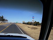
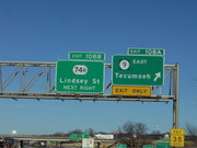
SH-74 has five spur routes (starting at B, and going up to a suffix of F)- SH-74A (2.7 mi, 4.3 km) ran along Lindsey Street in NormanNorman, OklahomaNorman is a city in Cleveland County, Oklahoma, United States, and is located south of downtown Oklahoma City. It is part of the Oklahoma City metropolitan area. As of the 2010 census, Norman was to have 110,925 full-time residents, making it the third-largest city in Oklahoma and the...
, connecting I-35 to US-77. This highway ran straight through the University of OklahomaUniversity of OklahomaThe University of Oklahoma is a coeducational public research university located in Norman, Oklahoma. Founded in 1890, it existed in Oklahoma Territory near Indian Territory for 17 years before the two became the state of Oklahoma. the university had 29,931 students enrolled, most located at its...
campus. It connected to the section of SH-74 which was converted to I-35. This highway was decommissioned in April 2009. - SH-74B (10.0 mi, 16.1 km) connects SH-74 in Goldsby to SH-76State Highway 76 (Oklahoma)State Highway 76, also referred to as SH-76 or OK-76, is a highway maintained by the U.S. state of Oklahoma. It is 110.7 miles long. It runs north–south through central Oklahoma, beginning at Jimtown Road just north of the Red River and ending north of Newcastle at SH-37...
south of BlanchardBlanchard, OklahomaBlanchard is a city in Grady and McClain counties in the U.S. state of Oklahoma. The population was 7,670 at the 2010 census. Blanchard is part of a rapidly growing area of northern McClain and Grady Counties known as the "Tri-City Area" with Newcastle and Tuttle.-Early history:Blanchard is...
. ColeCole, OklahomaCole is a town in McClain County, Oklahoma, United States. The population was 473 at the 2000 census.- History :Cole was originally founded on of land donated by Mrs. A. E. Cunningham and Judge Presley Cole. The town was named Cole after it was decided Cunningham was too long a name...
lies along the middle of this hilly spur. - SH-74C (11.6 mi, 18.7 km) connects SH-74 in Crescent to US-77 north of GuthrieGuthrie, OklahomaGuthrie is a city in and the county seat of Logan County, Oklahoma, United States, and a part of the Oklahoma City Metroplex. The population was 9,925 at the 2000 census.Guthrie was the territorial and later the first state capital for Oklahoma...
. - SH-74D (2.9 mi, 4.7 km) connects SH-74 to the unincorporated community of Lovell.
- SH-74E (5 mi, 8.1 km) goes from SH-51 north to MarshallMarshall, OklahomaMarshall is a rural town in Logan County, Oklahoma, United States, and is an outer suburb/exurb on the northern edge of the Oklahoma City Metropolitan Statistical Area. The population was 258 at the 2000 census. The population for the Marshall U.S...
, and then it goes east and ends at SH-74. This spur was commissioned on 1951-08-06. - SH-74F (8.0 mi, 12.9 km) goes from SH-74 west to CashionCashion, OklahomaCashion is a town in Kingfisher and Logan counties in the U.S. state of Oklahoma. The Logan County portion of Cashion is part of the Oklahoma City Metropolitan Statistical Area...
, and then goes north to SH-33State Highway 33 (Oklahoma)Oklahoma's State Highway 33 is a major highway that traverses most of the state, and at one time traversed the entire state. Its general orientation is west to east. All mileages listed herein are from the western terminus of the highway at the Texas state line.-Roger Mills County:SH-33 begins...
. - Historically, Green Avenue on the north side of Purcell from SH-74 to I-35 was designated SH-74G. However, this designation was removed, and is currently signed as To NORTH I-35.