

Starved Rock Lock and Dam
Encyclopedia
Starved Rock Lock and Dam, also known as Lock and Dam No. 6, is a lock and dam facility managed by the U.S. Army Corps of Engineers along the Illinois River
. It is part of the Illinois Waterway
and was constructed between 1926 and 1933. The lock and dam was added to the National Register of Historic Places as the Starved Rock Lock and Dam Historic District in 2004.
, Starved Rock Lock and Dam is the southernmost facility. The lock and dam are located along the Illinois River
near the north central Illinois
village of Utica. The lock and dam is at river mile
231 just downstream from Plum Island
. The facility is presently operated by the U.S. Army Corps of Engineers.
to the Gulf of Mexico
via the Mississippi River
. The contract for construction of the lock and dam was originally awarded in 1923 but fell through when the contractor failed to show up for the contract signing. Following a period of time during which land litigation issues were cleared, a second contract was awarded in 1926. The lock and dam was about 95 percent complete when the state of Illinois fell upon financial difficultly and the project was turned over to the federal government for completion. Under the authority of the Rivers and Harbors Act of 1930
the federal government oversaw completion of Starved Rock Lock and Dam in 1933. Construction of the facility cost US$4,462,737, of that amount $3,577,419 was provided by the state and $885,318 was federal money.
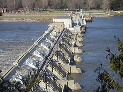
gravity dam 1310 feet (399.3 m) long. The dam consists of a headgate of 518 feet (157.9 m) and a controlled spillway of 714 feet (217.6 m). The dam is 33 feet (10.1 m) wide at its base, 22 in 3 in (6.78 m) wide at the crest of the headgate and 50 in 6 in (15.39 m) wide at the crest of the spillway
. The dam's height above the riverbed varies from 21 to 34 ft (6.4 to 10.4 m).
The lock at Starved Rock Lock and Dam is a Ohio River Standard navigational lock
of 110 by. The lock has a drop/lift of about 18 feet (5 m). The chamber of the lock is formed by two parallel gravity section walls 38 feet (11.6 m) tall on the north and south. These are framed horizontally by two miter gates at the east and west ends of the lock.
Walter Smith Mickle was hired as Chief Design Engineer for the Illinois Waterway Project by Mortimer Grant Barnes, Illinois Governor Frank O. Lowden's appointee to oversee the Waterway Project. Thus, Mickle designed the facilities at Starved Rock Lock and Dam. Legislation which codified the construction of the Waterway only stipulated the general design and location of the locks and dams along the Illinois River, the details were left to Barnes, Smith and other engineers. Barnes had 20 years' experience as a civil engineer
and had worked as an assistant to the engineer in charge of the construction of the Panama Canal locks
when Lowden tapped him to head the project. Smith worked with Barnes on the Panama Canal
project; they had both resigned in 1907 to go to work for the New York Board of Water Supply. Together the two men also formed a general hydraulic and construction engineering
firm.
as the Starved Rock Lock and Dam Historic District. It was listed as part of the Illinois Waterway Navigation System Facilities Multiple Property Submission. Starved Rock was deemed eligible for the listing when the rest of the Illinois Waterway was also determined eligible; the day Starved Rock Lock and Dam was listed the other 7 lock and dam sites on the Waterway were also listed on the National Register of Historic Places.
The district has significance in three areas, according to the National Register of Historic Places' criteria, those are, engineering, transportation and maritime history. The historic district
consists of five total buildings and structures. One building and two structures are contributing members to the historic district and two buildings are considered non-contributing members. Starved Rock Lock and Dam Historic District covers 27.95 acres (113,109.7 m²).
Illinois River
The Illinois River is a principal tributary of the Mississippi River, approximately long, in the State of Illinois. The river drains a large section of central Illinois, with a drainage basin of . This river was important among Native Americans and early French traders as the principal water route...
. It is part of the Illinois Waterway
Illinois Waterway
The Illinois Waterway system consists of of water from the mouth of the Calumet River to the mouth of the Illinois River at Grafton, Illinois. It is a system of rivers, lakes, and canals which provide a shipping connection from the Great Lakes to the Gulf of Mexico via the Mississippi River. The...
and was constructed between 1926 and 1933. The lock and dam was added to the National Register of Historic Places as the Starved Rock Lock and Dam Historic District in 2004.
Location
Along the original Illinois WaterwayIllinois Waterway
The Illinois Waterway system consists of of water from the mouth of the Calumet River to the mouth of the Illinois River at Grafton, Illinois. It is a system of rivers, lakes, and canals which provide a shipping connection from the Great Lakes to the Gulf of Mexico via the Mississippi River. The...
, Starved Rock Lock and Dam is the southernmost facility. The lock and dam are located along the Illinois River
Illinois River
The Illinois River is a principal tributary of the Mississippi River, approximately long, in the State of Illinois. The river drains a large section of central Illinois, with a drainage basin of . This river was important among Native Americans and early French traders as the principal water route...
near the north central Illinois
Illinois
Illinois is the fifth-most populous state of the United States of America, and is often noted for being a microcosm of the entire country. With Chicago in the northeast, small industrial cities and great agricultural productivity in central and northern Illinois, and natural resources like coal,...
village of Utica. The lock and dam is at river mile
River mile
In the United States, a River mile is a measure of distance in miles along a river from its mouth. River mile numbers begin at zero and increase further upstream. The corresponding metric unit using kilometers is the River kilometer...
231 just downstream from Plum Island
Plum Island Eagle Sanctuary
The Plum Island Eagle Sanctuary is a 52-acre island in the Illinois River owned by the Illinois Audubon Society. It was purchased in 2004 to act as a wildlife sanctuary, to encourage and support the nesting and breeding of the bald eagle...
. The facility is presently operated by the U.S. Army Corps of Engineers.
History
The Starved Rock Lock and Dam was constructed between 1926 and 1933 as an element of the Illinois Waterway. The Waterway was a project designed to provide a navigable channel from the Great LakesGreat Lakes
The Great Lakes are a collection of freshwater lakes located in northeastern North America, on the Canada – United States border. Consisting of Lakes Superior, Michigan, Huron, Erie, and Ontario, they form the largest group of freshwater lakes on Earth by total surface, coming in second by volume...
to the Gulf of Mexico
Gulf of Mexico
The Gulf of Mexico is a partially landlocked ocean basin largely surrounded by the North American continent and the island of Cuba. It is bounded on the northeast, north and northwest by the Gulf Coast of the United States, on the southwest and south by Mexico, and on the southeast by Cuba. In...
via the Mississippi River
Mississippi River
The Mississippi River is the largest river system in North America. Flowing entirely in the United States, this river rises in western Minnesota and meanders slowly southwards for to the Mississippi River Delta at the Gulf of Mexico. With its many tributaries, the Mississippi's watershed drains...
. The contract for construction of the lock and dam was originally awarded in 1923 but fell through when the contractor failed to show up for the contract signing. Following a period of time during which land litigation issues were cleared, a second contract was awarded in 1926. The lock and dam was about 95 percent complete when the state of Illinois fell upon financial difficultly and the project was turned over to the federal government for completion. Under the authority of the Rivers and Harbors Act of 1930
Rivers and Harbors Act
Rivers and Harbors Act may refer to one of many pieces of legislation and appropriations passed by the United States Congress since the first such legislation in 1824. At that time congress appropriated $75,000 to improve navigation on the Ohio and Mississippi rivers by removing sandbars, snags,...
the federal government oversaw completion of Starved Rock Lock and Dam in 1933. Construction of the facility cost US$4,462,737, of that amount $3,577,419 was provided by the state and $885,318 was federal money.
Design
Starved Rock Lock and Dam features a straight-crested, reinforced concreteReinforced concrete
Reinforced concrete is concrete in which reinforcement bars , reinforcement grids, plates or fibers have been incorporated to strengthen the concrete in tension. It was invented by French gardener Joseph Monier in 1849 and patented in 1867. The term Ferro Concrete refers only to concrete that is...
gravity dam 1310 feet (399.3 m) long. The dam consists of a headgate of 518 feet (157.9 m) and a controlled spillway of 714 feet (217.6 m). The dam is 33 feet (10.1 m) wide at its base, 22 in 3 in (6.78 m) wide at the crest of the headgate and 50 in 6 in (15.39 m) wide at the crest of the spillway
Spillway
A spillway is a structure used to provide the controlled release of flows from a dam or levee into a downstream area, typically being the river that was dammed. In the UK they may be known as overflow channels. Spillways release floods so that the water does not overtop and damage or even destroy...
. The dam's height above the riverbed varies from 21 to 34 ft (6.4 to 10.4 m).
The lock at Starved Rock Lock and Dam is a Ohio River Standard navigational lock
Lock (water transport)
A lock is a device for raising and lowering boats between stretches of water of different levels on river and canal waterways. The distinguishing feature of a lock is a fixed chamber in which the water level can be varied; whereas in a caisson lock, a boat lift, or on a canal inclined plane, it is...
of 110 by. The lock has a drop/lift of about 18 feet (5 m). The chamber of the lock is formed by two parallel gravity section walls 38 feet (11.6 m) tall on the north and south. These are framed horizontally by two miter gates at the east and west ends of the lock.
Walter Smith Mickle was hired as Chief Design Engineer for the Illinois Waterway Project by Mortimer Grant Barnes, Illinois Governor Frank O. Lowden's appointee to oversee the Waterway Project. Thus, Mickle designed the facilities at Starved Rock Lock and Dam. Legislation which codified the construction of the Waterway only stipulated the general design and location of the locks and dams along the Illinois River, the details were left to Barnes, Smith and other engineers. Barnes had 20 years' experience as a civil engineer
Civil engineer
A civil engineer is a person who practices civil engineering; the application of planning, designing, constructing, maintaining, and operating infrastructures while protecting the public and environmental health, as well as improving existing infrastructures that have been neglected.Originally, a...
and had worked as an assistant to the engineer in charge of the construction of the Panama Canal locks
Panama Canal Locks
The Panama Canal Locks, which lift ships up 25.9 m to the main elevation of the Panama Canal, were one of the greatest engineering works ever to be undertaken at the time, eclipsed only by other parts of the canal project. No other concrete construction of comparable size was undertaken...
when Lowden tapped him to head the project. Smith worked with Barnes on the Panama Canal
Panama Canal
The Panama Canal is a ship canal in Panama that joins the Atlantic Ocean and the Pacific Ocean and is a key conduit for international maritime trade. Built from 1904 to 1914, the canal has seen annual traffic rise from about 1,000 ships early on to 14,702 vessels measuring a total of 309.6...
project; they had both resigned in 1907 to go to work for the New York Board of Water Supply. Together the two men also formed a general hydraulic and construction engineering
Construction engineering
Construction engineering is a professional discipline that deals with the designing, planning, construction, and management of infrastructures such as highways, bridges, airports, railroads, buildings, dams, and utilities. Construction Engineers are unique such that they are a cross between civil...
firm.
Historic district
On March 10, 2004 the Starved Rock Lock and Dam was listed on the National Register of Historic PlacesNational Register of Historic Places
The National Register of Historic Places is the United States government's official list of districts, sites, buildings, structures, and objects deemed worthy of preservation...
as the Starved Rock Lock and Dam Historic District. It was listed as part of the Illinois Waterway Navigation System Facilities Multiple Property Submission. Starved Rock was deemed eligible for the listing when the rest of the Illinois Waterway was also determined eligible; the day Starved Rock Lock and Dam was listed the other 7 lock and dam sites on the Waterway were also listed on the National Register of Historic Places.
The district has significance in three areas, according to the National Register of Historic Places' criteria, those are, engineering, transportation and maritime history. The historic district
Historic district (United States)
In the United States, a historic district is a group of buildings, properties, or sites that have been designated by one of several entities on different levels as historically or architecturally significant. Buildings, structures, objects and sites within a historic district are normally divided...
consists of five total buildings and structures. One building and two structures are contributing members to the historic district and two buildings are considered non-contributing members. Starved Rock Lock and Dam Historic District covers 27.95 acres (113,109.7 m²).