
St Georges Rd Trail
Encyclopedia
The St Georges Road Trail is a shared use path for cyclists
and pedestrian
s, which follows Cheddar and St Georges Road in the inner northern suburbs of Reservoir
, Preston
and Thornbury
in Melbourne
, Victoria
, Australia
.
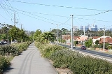
The trail is somewhat unusual, in that part of the way, it is located on the wide traffic island that divides the road in two, instead of being located beside the road. As a consequence, somewhat more care has to be taken when crossing at the intersections.
The trail was first constructed in the mid 1990s down the median strip of St Georges Road, but the section between Bell Street and Miller Street, which runs beside the road instead, was not completed until 2005.
at Dalton Road. There are no signs to the St Georges Road Trail at this point. Dalton Rd is unsuitable for cycling due to the heavy vehicles using the road. Using the footpath on the west side of Dalton Road, continue 400m south from the highway, to the start of a 600m low quality sandy shared path in the City of Whittlesea
. It ends 160 metres north of the Keon Pde/Dalton Rd/Tunaley Pde intersection. Continue on the west side of Dalton Rd via the footpath to the intersection. Use the pedestrian crossing to cross to the east side of Dalton Rd and Tunaley Pde. The high quality trail in the City of Darebin
, starts at Tunaley Pde, 1.4km from the Metropolitan Ring Road and heads down the Yan Yean
pipe reserve.
From there it follows Cheddar Road to a large intersection at the Reservoir
shopping area and comes to a stop. Use the pedestrian crossings to cross SW to Reservoir railway station. The path restarts adjacent to the station car park. Continue between the reservoirs hiding behind the rows of trees lining the street on either side. The path continues diagonally in the GE Robinson reserve, beside the palms
.
On the south side of the park the trail runs parallel to Robinson Road past Regent railway station. Follow the train line. 600m later, the path crosses the tracks and soon reaches St Georges Road and Murray Road.
Carefully cross over to the dividing strip going down the middle of St Georges Road. The path passes the Preston Campus of the Northern Melbourne Institute of TAFE
. The trail stays on the dividing strip the whole way, except for a 500m section, between Ray Braham Gardens and Miller Street by the tram
corral.
The most southerly end of the trail previously terminated at a roundabout with St Georges Road, Charles Street and Merri Parade. The roundabout was a blackspot for cyclists. The roundabout was removed in 2009. The Merri Creek Trail
and Capital City Trail
can be accessed by proceeding to the nearby Merri Parade.
North end at 37.696450°S 145.022673°E.
South end at 37.776796°S 144.989642°E.
Cycling
Cycling, also called bicycling or biking, is the use of bicycles for transport, recreation, or for sport. Persons engaged in cycling are cyclists or bicyclists...
and pedestrian
Pedestrian
A pedestrian is a person traveling on foot, whether walking or running. In some communities, those traveling using roller skates or skateboards are also considered to be pedestrians. In modern times, the term mostly refers to someone walking on a road or footpath, but this was not the case...
s, which follows Cheddar and St Georges Road in the inner northern suburbs of Reservoir
Reservoir, Victoria
Reservoir is a suburb in Melbourne, Victoria, Australia, 12 km north from Melbourne's central business district. Its Local Government Area is the City of Darebin. At the 2006 Census, Reservoir had a population of 45,970....
, Preston
Preston, Victoria
Preston is a suburb in Melbourne, Victoria, Australia, 9 km north from Melbourne's central business district. Its Local Government Area is the City of Darebin. At the 2006 Census, Preston had a population of 27,892.-Settlement:...
and Thornbury
Thornbury, Victoria
Thornbury originalSince the 1960s, the vast majority of Melburnians pronounce the name phonetically. The 'h' is no longer silent, and there is more stress placed upon the 'o'. pronunciation is a suburb in Melbourne, Victoria, Australia, 7 km north from Melbourne's central business district....
in Melbourne
Melbourne
Melbourne is the capital and most populous city in the state of Victoria, and the second most populous city in Australia. The Melbourne City Centre is the hub of the greater metropolitan area and the Census statistical division—of which "Melbourne" is the common name. As of June 2009, the greater...
, Victoria
Victoria (Australia)
Victoria is the second most populous state in Australia. Geographically the smallest mainland state, Victoria is bordered by New South Wales, South Australia, and Tasmania on Boundary Islet to the north, west and south respectively....
, Australia
Australia
Australia , officially the Commonwealth of Australia, is a country in the Southern Hemisphere comprising the mainland of the Australian continent, the island of Tasmania, and numerous smaller islands in the Indian and Pacific Oceans. It is the world's sixth-largest country by total area...
.
The trail is somewhat unusual, in that part of the way, it is located on the wide traffic island that divides the road in two, instead of being located beside the road. As a consequence, somewhat more care has to be taken when crossing at the intersections.
The trail was first constructed in the mid 1990s down the median strip of St Georges Road, but the section between Bell Street and Miller Street, which runs beside the road instead, was not completed until 2005.
Following the Path
Leave the Western Ring Road TrailWestern Ring Road Trail
The Western Ring Road Trail is a shared use path for cyclists and pedestrians that bridges the northern suburbs and follows the Western Ring Road...
at Dalton Road. There are no signs to the St Georges Road Trail at this point. Dalton Rd is unsuitable for cycling due to the heavy vehicles using the road. Using the footpath on the west side of Dalton Road, continue 400m south from the highway, to the start of a 600m low quality sandy shared path in the City of Whittlesea
City of Whittlesea
The City of Whittlesea is a Local Government Area located in the outer northeastern suburbs of Melbourne, the state capital of Victoria, Australia. The city covers an area of , and has an estimated population of 155,113 people.-History:...
. It ends 160 metres north of the Keon Pde/Dalton Rd/Tunaley Pde intersection. Continue on the west side of Dalton Rd via the footpath to the intersection. Use the pedestrian crossing to cross to the east side of Dalton Rd and Tunaley Pde. The high quality trail in the City of Darebin
City of Darebin
The City of Darebin is a Local Government Area in Victoria, Australia, located in the northern suburbs of Melbourne. It has an area of , and as of 2009, has a population of 139,608...
, starts at Tunaley Pde, 1.4km from the Metropolitan Ring Road and heads down the Yan Yean
Yan Yean Reservoir
Yan Yean Reservoir is the oldest water supply for the city of Melbourne, Australia. It is built on the Plenty River a tributary of the Yarra River, 30 km north of the city. A 9.5 metre embankment holds back 30,000 megalitres of water...
pipe reserve.
From there it follows Cheddar Road to a large intersection at the Reservoir
Reservoir, Victoria
Reservoir is a suburb in Melbourne, Victoria, Australia, 12 km north from Melbourne's central business district. Its Local Government Area is the City of Darebin. At the 2006 Census, Reservoir had a population of 45,970....
shopping area and comes to a stop. Use the pedestrian crossings to cross SW to Reservoir railway station. The path restarts adjacent to the station car park. Continue between the reservoirs hiding behind the rows of trees lining the street on either side. The path continues diagonally in the GE Robinson reserve, beside the palms
Canary Island Date Palm
Phoenix canariensis is a species in the palm family Arecaceae, native to the Canary Islands. It is a relative of Phoenix dactylifera, the true date palm....
.
On the south side of the park the trail runs parallel to Robinson Road past Regent railway station. Follow the train line. 600m later, the path crosses the tracks and soon reaches St Georges Road and Murray Road.
Carefully cross over to the dividing strip going down the middle of St Georges Road. The path passes the Preston Campus of the Northern Melbourne Institute of TAFE
Northern Melbourne Institute of TAFE
Northern Melbourne Institute of TAFE is a TAFE institute located in the northern suburbs of Melbourne, Victoria, Australia. It has six city campuses located at Preston, Collingwood, Epping, Fairfield, Greensborough, Heidelberg, a country campus at Ararat, and country training facilities at Eden...
. The trail stays on the dividing strip the whole way, except for a 500m section, between Ray Braham Gardens and Miller Street by the tram
Trams in Melbourne
The Melbourne tramway network is a major form of public transport in Melbourne, the capital city of the state of Victoria, Australia. , the network consisted of of track, 487 trams, 28 routes, and 1,773 tram stops. It was therefore the largest urban tramway network in the world, ahead of the...
corral.
The most southerly end of the trail previously terminated at a roundabout with St Georges Road, Charles Street and Merri Parade. The roundabout was a blackspot for cyclists. The roundabout was removed in 2009. The Merri Creek Trail
Merri Creek Trail
The Merri Creek Trail is a shared use path for cyclists and pedestrians, which follows the Merri Creek through the northern suburbs of Melbourne, Victoria, Australia.-Following the Path:...
and Capital City Trail
Capital City Trail
The Capital City Trail is a shared use path for cyclists and pedestrians, which circles the Melbourne city centre and some inner eastern and northern suburbs of Melbourne, Victoria, Australia....
can be accessed by proceeding to the nearby Merri Parade.
Connections
- Nearly reaches the Western Ring Road TrailWestern Ring Road TrailThe Western Ring Road Trail is a shared use path for cyclists and pedestrians that bridges the northern suburbs and follows the Western Ring Road...
in the north - Connects to the Merri Creek TrailMerri Creek TrailThe Merri Creek Trail is a shared use path for cyclists and pedestrians, which follows the Merri Creek through the northern suburbs of Melbourne, Victoria, Australia.-Following the Path:...
in the south. - In April 2010 connections to the Capital City TrailCapital City TrailThe Capital City Trail is a shared use path for cyclists and pedestrians, which circles the Melbourne city centre and some inner eastern and northern suburbs of Melbourne, Victoria, Australia....
were improved with the addition of a new bridge across Merri Creek, 160m south of the junction of Union Street and Merri Parade, not far from the St Georges Road trail.
North end at 37.696450°S 145.022673°E.
South end at 37.776796°S 144.989642°E.