

Sri Aurobindo Marg
Encyclopedia
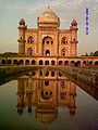
Sri Aurobindo Marg or Aurobindo Marg, is an important South Delhi
north-south arterial road
connecting historic Safdarjung's Tomb
to Qutab Minar. The road is named for Sri Aurobindo Ghosh
; the Delhi campus of Sri Aurobindo Ashram
is located on the road. The road was originally known as Mehrauli Road.
The road is a primary conduit for traffic from North Delhi
and Central Delhi
, including the commercial hub of Connaught Place
, to points south and southwest of Delhi
, including Gurgaon
. The stations of Delhi Metro
, Race Course, INA, AIIMS and Green Park (Yellow Line) lie on this road.
Major intersections on Aurobindo Marg include, from north to south, include:
 A number of major South Delhi institutions, neighborhoods, and historical monuments are located on or along Aurobindo Marg:
South Delhi
South Delhi is an administrative district of the National Capital Territory of Delhi in India.It is bounded by the Yamuna River to the east, the districts of New Delhi to the north, Faridabad District of Haryana state to the southeast, Gurgaon District of Haryana to the southwest, and South West...
north-south arterial road
Arterial road
An arterial road, or arterial thoroughfare, is a high-capacity urban road. The primary function of an arterial road is to deliver traffic from collector roads to freeways, and between urban centres at the highest level of service possible. As such, many arteries are limited-access roads, or feature...
connecting historic Safdarjung's Tomb
Safdarjung's Tomb
Safdarjung's Tomb is a garden tomb with a marble mausoleum in New Delhi, India. It was built in 1754 in the late Mughal Empire style, and was described as "the last flicker in the lamp of Mughal architecture". The top storey of the edifice houses the Archaeological Survey of India...
to Qutab Minar. The road is named for Sri Aurobindo Ghosh
Sri Aurobindo
Sri Aurobindo , born Aurobindo Ghosh or Ghose , was an Indian nationalist, freedom fighter, philosopher, yogi, guru, and poet. He joined the Indian movement for freedom from British rule and for a duration became one of its most important leaders, before developing his own vision of human progress...
; the Delhi campus of Sri Aurobindo Ashram
Sri Aurobindo Ashram
The Sri Aurobindo Ashram was founded by Sri Aurobindo on the 24 November 1926 . At the time there were no more than 24 disciples in the Ashram...
is located on the road. The road was originally known as Mehrauli Road.
The road is a primary conduit for traffic from North Delhi
North Delhi
North Delhi is an administrative district of the National Capital Territory of Delhi in India.North Delhi is bounded by the Yamuna River on the east, and by the districts of North West Delhi to the north and west, West Delhi to the southwest, Central Delhi to the south, and North East Delhi to the...
and Central Delhi
Central Delhi
Central Delhi is an administrative district of the National Capital Territory of Delhi in India.It is bounded by the Yamuna River on the east, and by the districts of North Delhi to the north, West Delhi and South West Delhi to the west, New Delhi to the south, and East Delhi to the east across the...
, including the commercial hub of Connaught Place
Connaught Place, New Delhi
Connaught Place Connaught Place Connaught Place (Hindi: कनॉट प्लेस, (officially Rajiv Chowk) is one of the largest financial, commercial and business centers in Delhi. It is often abbreviated as CP and houses the headquarters of several Indian firms. Its surroundings occupy a place of pride...
, to points south and southwest of Delhi
Delhi
Delhi , officially National Capital Territory of Delhi , is the largest metropolis by area and the second-largest by population in India, next to Mumbai. It is the eighth largest metropolis in the world by population with 16,753,265 inhabitants in the Territory at the 2011 Census...
, including Gurgaon
Gurgaon
Gurgaon is the second largest city in the Indian state of Haryana. Gurgaon is the industrial and financial center of Haryana. It is located 30 km south of national capital New Delhi, about 10 kilometers from Dwarka Sub City and 268 km south of Chandigarh, the state capital...
. The stations of Delhi Metro
Delhi Metro
Delhi Metro is a rapid transit system serving Delhi, Gurgaon, Noida and Ghaziabad in the National Capital Region of India. It is one of the largest metro networks in the world. The network consists of six lines with a total length of with 142 stations of which 35 are underground...
, Race Course, INA, AIIMS and Green Park (Yellow Line) lie on this road.
Major intersections
The northern terminus of Aurobindo Marg is located at Safdarjung's Tomb. At the southern end, Aurobindo Marg terminates near the Lado Sarai bus terminal.Major intersections on Aurobindo Marg include, from north to south, include:
- The northern terminus, dividing into Safdarjung RoadSafdarjung RoadSafdarjung Road is a main road, in New Delhi, India, named after 18th century Safdarjung's Tomb near it. At the north end, the road stretches from the junction of Teen Murti Marg, Akbar Road, Rajaji Marg and Racecourse Road, which is a roundabout...
heading northwest, Tughlaq RoadTughlaq RoadTughlaq Road is one of the main roads of Central New Delhi-North End:This road stretches from the roundabout at the junction of Krishna Menon Road, Akbar road east & west sides and Tees January Marg, in the north.-South end:This road stretches up to the junction of Safdarjung road, Prithviraj Road...
heading directly north, and Prithviraj RoadPrithviraj RoadPrithviraj Road is one of the main roads of New Delhi.-North End:It stretches from the Taj Mansingh Hotel at the junction of Mansingh Road, Aurangzeb Road, Humayun Road, Shahjahan Road, a road to Khan Market.-South End:It stretches up to the junction of Sri Aurobindo Marg Road, Safdarjung road and...
to the northeast. - Interchange with the Ring Road to points east and west.
- Interchange with the Outer Ring Road to points east and west.
- Interchange with Press Enclave Marg to points east.
- The southern terminus, with Anuvrat Marg continuing on the roadway towards MehrauliMehrauliMehrauli is a neighbourhood in the South West district of Delhi in India. It represents a constituency in the legislative assembly of Delhi. The area is located close to Gurgaon.-History:...
, Gurgaon and points southwest of Delhi, and the Mehrauli-Badarpur Road, due west towards National Highway 2.
Points of interest
- Safdarjung's TombSafdarjung's TombSafdarjung's Tomb is a garden tomb with a marble mausoleum in New Delhi, India. It was built in 1754 in the late Mughal Empire style, and was described as "the last flicker in the lamp of Mughal architecture". The top storey of the edifice houses the Archaeological Survey of India...
- Safdarjung AirportSafdarjung AirportSafdarjung Airport also is an airport in New Delhi, India, in the neighbourhood of the same name. Established during the British Raj, as Willingdon Airfield, it started operations as an airport in 1929, when was the India's second airport and Delhi’s only airport...
, where Rajiv Gandhi BhawanRajiv Gandhi BhawanRajiv Gandhi Bhawan is the corporate headquarters of Airports Authority of India . AAI which functions under the Ministry of Civil Aviation and manages most of the airports in India. The Indian Ministry of Civil Aviation is co-located in the same building...
the corporate headquarters of Airports Authority of IndiaAirports Authority of IndiaThe Airports Authority of India is an organization working under the Ministry of Civil Aviation that manages most of the airports in India. The AAI manages and operates 126 airports including 16 international airports, 89 domestic airports and 26 civil enclaves. The corporate headquarters are at...
(AAI) is located. - INA Market
- Dilli HaatDilli HaatDilli Haat is a open-air food plaza cum craft bazaar located in Delhi, run by Delhi Tourism and Transportation Development Corporation . At present Delhi has two such bazaars, one near the All India Institute of Medical Sciences on Sri Aurobindo Marg, opposite INA Market on Sri Aurobindo Marg...
- AIIMS, Safdarjung Hospital
- Yusuf SaraiYusuf Sarai-Main Road:The main road in this area is Sri Aurobindo Marg. It is on the stretch between AIIMS / Safdarjung Hospital on one end and Green Park Metro Station on the other. The stretch has shops on either side. On one side, it leads to 'Mandir wali gali', a flea market and on the other side, a road...
- Green ParkGreen Park, DelhiGreen Park is a locality, in the South Delhi district of Delhi, India. Today it is known as an important shopping districts of Delhi, the Green Park market.-History:...
- Hauz KhasHauz KhasHauz Khas Complex in South Delhi houses a water tank, an Islamic seminary, a mosque, a tomb and pavilions built around an urbanized village with medieval history traced to the 13th century of Delhi Sultanate reign...
- IIT DelhiIndian Institute of Technology DelhiThe Indian Institute Of Technology, Delhi , commonly known as IIT Delhi or IITD, is a college of engineering in Delhi, India...
- Sri Aurobindo AshramSri Aurobindo AshramThe Sri Aurobindo Ashram was founded by Sri Aurobindo on the 24 November 1926 . At the time there were no more than 24 disciples in the Ashram...
- Sarvodaya EnclaveSarvodaya EnclaveSarvodaya Enclave is an affluent residence colony in the South Delhi District of New Delhi.- How to enter :The main entry into Sarvodaya Enclave is by taking a left on Sri Aurobindo Marg, after Essex farms in the road leading to Adchini Village...
- Adchini Village
- Lado Sarai Golf Club
- Qutb complexQutb complexThe Qutb complex , also spelled Qutab or Qutub, is an array of monuments and buildings at Mehrauli in Delhi, India. The construction of Qutb Minar was intended as a Victory Tower, to celebrate the victory of Mohammed Ghori over Rajput king, Prithviraj Chauhan, in 1192 AD, by his then viceroy,...
, MehrauliMehrauliMehrauli is a neighbourhood in the South West district of Delhi in India. It represents a constituency in the legislative assembly of Delhi. The area is located close to Gurgaon.-History:...