
Springbrook, Queensland
Encyclopedia
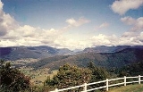
Springbrook is a suburb, mountain and plateau
in the Gold Coast hinterland
of South East Queensland
. The highest point, known as Springbrook Mountain is 900 metres (2,952.8 ft) high. The area offers excellent views to the Gold Coast
and is known for its cliffs, waterfalls and forest walks, most of which are protected in the Springbrook National Park
.
 Road access to this eastern Scenic Rim
mountain is via Mudgeeraba
. To the south of Springbrook is the Tweed Range
, west is the Numinbah Valley
and the Lamington Plateau. Both the Nimmel Range and Tambourine Mountain
are to the north.
Springbrook was the site for a trial that involved 200 distributed, wireless sensors that can monitor natural conditions such as humidity, temperature, light, rainfall, fog, water quality and sound. The cutting edge technology was developed by the CSIRO
to assist research into the restoration of natural vegetation.
—now known as Mount Warning
. The plateau is an undulating elevated patch that extends north from the southern, forested heights, close to Mount Cougal, just to the east. These subtropical rainforest
s are part of the Gondwana Rainforests of Australia and contain the rare Antarctic beech
trees.
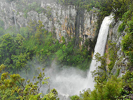
Notable lookouts on the plateau include Best of All Lookout, overlooking the Tweed Valley directly south of Springbrook, as well as Canyon, Goomoolahra and Purlingbrook lookouts. Springbrook features the Purlingbrook Falls
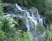
, which is a major tourist attraction as well as Goomoolahra Falls
. Another major tourist attraction on the mountain is the English Gardens known for its tulip
s and other English bulbs that flower in Spring.
 The plateau is highly visible on the western horizon from the Gold Coast coastal strip. Springbrook Plateau is in the water catchment area for Tallebudgera Creek
and the larger Nerang River
dammed by the Hinze Dam
, a significant part of the region's water supply infrastructure.
. They found farming difficult and instead cleared for the land for timber. By the 1930s Springbrook was almost completely cleared of trees. In 1911 a school opened and by 1947 a community hall had been built. Tourism has been the major industry since the 1920s, with many guesthouses opening during this period.
Springwood was the first name chosen for the locality, however it was changed to Springbrook to avoid confusion with mail deliveries to another Springwood
located in the Blue Mountains.
Plateau
In geology and earth science, a plateau , also called a high plain or tableland, is an area of highland, usually consisting of relatively flat terrain. A highly eroded plateau is called a dissected plateau...
in the Gold Coast hinterland
Gold Coast hinterland
The Gold Coast hinterland is an area of South East Queensland, Australia that comprises the Tweed Range, Nimmel Range, Tamborine Mountain, Numinbah Valley, eastern parts of the McPherson Range and western parts of suburban Gold Coast.-History:...
of South East Queensland
South East Queensland
South East Queensland is a region of the state of Queensland in Australia, which contains approximately two-thirds of the state population...
. The highest point, known as Springbrook Mountain is 900 metres (2,952.8 ft) high. The area offers excellent views to the Gold Coast
Gold Coast, Queensland
Gold Coast is a coastal city of Australia located in South East Queensland, 94km south of the state capital Brisbane. With a population approximately 540,000 in 2010, it is the second most populous city in the state, the sixth most populous city in the country, and also the most populous...
and is known for its cliffs, waterfalls and forest walks, most of which are protected in the Springbrook National Park
Springbrook National Park
Springbrook National Park is a national park at Springbrook on the McPherson Range in the Gold Coast hinterland of Queensland, , 96 km south of Brisbane. It is part of the Shield Volcano Group of the World Heritage site Gondwana Rainforests of Australia...
.
Scenic Rim
The Scenic Rim is a group of forested mountain ranges of the Great Dividing Range straddling the border between south-eastern Queensland and north-eastern New South Wales, Australia.-Description:...
mountain is via Mudgeeraba
Mudgeeraba, Queensland
Mudgeeraba is a suburb of the Gold Coast. Mudgeeraba is remnant of the type of township that characterises the rural hinterland of the Gold Coast. Subdivision of land was conventional and buildings were traditionally rural or rural commercial. Mudgeeraba, like other areas, was an early centre,...
. To the south of Springbrook is the Tweed Range
Tweed Range
The Tweed Range is the western extension of the Tweed Volcano caldera rim in northern New South Wales, Australia. The range marks the southern extinct of the Scenic Rim. The Bar Mountain massif is the highest point on the range, rising to 1130 m above sea level...
, west is the Numinbah Valley
Numinbah Valley
The Numinbah Valley is an area of the Gold Coast hinterland in South East Queensland, Australia. This Scenic Rim valley contains many rocky outcrops, waterfalls, rainforest walks, and good hinterland scenery....
and the Lamington Plateau. Both the Nimmel Range and Tambourine Mountain
Tambourine Mountain
Tamborine Mountain is a plateau in the Scenic Rim, Gold Coast Hinterland, south-east Queensland, Australia. The name is of Aboriginal origin and has nothing to do with the musical instrument.-History:...
are to the north.
Springbrook was the site for a trial that involved 200 distributed, wireless sensors that can monitor natural conditions such as humidity, temperature, light, rainfall, fog, water quality and sound. The cutting edge technology was developed by the CSIRO
Commonwealth Scientific and Industrial Research Organisation
The Commonwealth Scientific and Industrial Research Organisation is the national government body for scientific research in Australia...
to assist research into the restoration of natural vegetation.
Plateau
Springbrook Plateau is the remains of the Tweed VolcanoTweed Volcano
Tweed Volcano was an early Miocene shield volcano in northeastern New South Wales, Australia. In the course of about three million years, Tweed Volcano was formed over the East Australia hotspot when this part of the continent passed over it around 23 million years ago...
—now known as Mount Warning
Mount Warning
Mount Warning is a mountain west-south-west of Murwillumbah, near the border with Queensland in the Northern Rivers region of New South Wales, Australia...
. The plateau is an undulating elevated patch that extends north from the southern, forested heights, close to Mount Cougal, just to the east. These subtropical rainforest
Rainforest
Rainforests are forests characterized by high rainfall, with definitions based on a minimum normal annual rainfall of 1750-2000 mm...
s are part of the Gondwana Rainforests of Australia and contain the rare Antarctic beech
Nothofagus moorei
Nothofagus moorei, is an important Gondwana relict of the rainforests of the southern hemisphere. It occurs in wet, fire free areas at high altitude in eastern Australia....
trees.
Notable lookouts on the plateau include Best of All Lookout, overlooking the Tweed Valley directly south of Springbrook, as well as Canyon, Goomoolahra and Purlingbrook lookouts. Springbrook features the Purlingbrook Falls
Purlingbrook Falls
Purlingbrook Falls are found within the central section of Springbrook National Park, at Springbrook which is part of the Gold Coast hinterland, south-west of Surfers Paradise, in Queensland, Australia....
, which is a major tourist attraction as well as Goomoolahra Falls
Goomoolahra Falls
Goomoolahra Falls are found within the Springbrook section of Springbrook National Park in Springbrook, part of the Gold Coast hinterland district of South East Queensland, Australia....
. Another major tourist attraction on the mountain is the English Gardens known for its tulip
Tulip
The tulip is a perennial, bulbous plant with showy flowers in the genus Tulipa, which comprises 109 species and belongs to the family Liliaceae. The genus's native range extends from as far west as Southern Europe, North Africa, Anatolia, and Iran to the Northwest of China. The tulip's centre of...
s and other English bulbs that flower in Spring.
Tallebudgera Creek
Tallebudgera Creek is a large creek on the Gold Coast which runs from the Springbrook Plateau in the west through Tallebudgera Valley to the southern slopes of Burleigh Mountain at Burleigh Heads and the Pacific Ocean in the east...
and the larger Nerang River
Nerang River
The Nerang River is a river that begins in the McPherson Range in the Gold Coast hinterland and runs through Gold Coast City in South East Queensland, Australia...
dammed by the Hinze Dam
Hinze Dam
The Hinze Dam, also known as Advancetown Lake, supplies most of the water provided to Gold Coast City in Queensland, Australia. Some water is drawn from Little Nerang Dam and until recently northern suburbs received water from Wivenhoe Dam. It was completed in 1976 and expanded in 1989. Advancetown...
, a significant part of the region's water supply infrastructure.
Climate
Due to its close proximity to the coast, the high elevations and subtropical latitude, Springbrook has a wet climate with mild temperatures. During a remarkable rainy period, Springbrook received 1,631mm in the month of June 1967.History
In 1906, settlers arrived from northern New South WalesNew South Wales
New South Wales is a state of :Australia, located in the east of the country. It is bordered by Queensland, Victoria and South Australia to the north, south and west respectively. To the east, the state is bordered by the Tasman Sea, which forms part of the Pacific Ocean. New South Wales...
. They found farming difficult and instead cleared for the land for timber. By the 1930s Springbrook was almost completely cleared of trees. In 1911 a school opened and by 1947 a community hall had been built. Tourism has been the major industry since the 1920s, with many guesthouses opening during this period.
Springwood was the first name chosen for the locality, however it was changed to Springbrook to avoid confusion with mail deliveries to another Springwood
Springwood, New South Wales
Springwood is a town in the Blue Mountains, New South Wales, Australia. Springwood is located 72 kilometres west of Sydney in the local government area of the City of Blue Mountains. At the 2006 census, Springwood had a population of 8,210 people. It is largely Anglo-Celtic.Springwood is near the...
located in the Blue Mountains.