
Nerang River
Encyclopedia
The Nerang River is a river that begins in the McPherson Range
in the Gold Coast hinterland
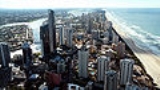
and runs through Gold Coast City
in South East Queensland
, Australia
. It starts in the Numinbah Valley
on the New South Wales
border and heads north, then east where it flows through Nerang
and onto the Gold Coast Broadwater
at Southport
on the Gold Coast
.
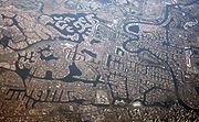
The Nerang River catchment covers an area of 490 km², with it only covering 250 km.
when he charted the Gold Coast in 1840, after Sir John Barrow
, Secretary of the Admiralty. The surveyor general Thomas Mitchell later changed many places to Aboriginal names, and this included giving the Nerang River its present name. Neerang is a Yugambeh
word meaning "little shark" or "shovel-nosed shark". But the local aboriginal people in fact called the river Mogumbin or Been-goor-abee. And the peoples of the Tweed called it Talgai.
, creating Advancetown Lake, the Gold Coast's main water supply. Hinze Dam has had a significant flood mitigation effect. An older dam, higher up in the catchment
and now called the Little Nerang Dam
was an earlier water supply for the Gold Coast. The dams are managed by Gold Coast Water
 The Gold Coast City Council is considering investing into the quality and capacity of the Surfers
Riverwalk
. The route would connect the Gold Coast Highway
Bridge crossing of the Nerang River at Main Beach
to Pacific Fair Shopping Centre
at Broadbeach
. The route includes
,and at the Nerang River Parklands.
McPherson Range
The McPherson Range is an extensive mountain range, a spur of the Great Dividing Range, heading in an easterly direction from near Wallangarra to the Pacific Ocean coastline. It forms part of the Scenic Rim on the border between the states of New South Wales and Queensland. Further west of the...
in the Gold Coast hinterland
Gold Coast hinterland
The Gold Coast hinterland is an area of South East Queensland, Australia that comprises the Tweed Range, Nimmel Range, Tamborine Mountain, Numinbah Valley, eastern parts of the McPherson Range and western parts of suburban Gold Coast.-History:...
and runs through Gold Coast City
Gold Coast, Queensland
Gold Coast is a coastal city of Australia located in South East Queensland, 94km south of the state capital Brisbane. With a population approximately 540,000 in 2010, it is the second most populous city in the state, the sixth most populous city in the country, and also the most populous...
in South East Queensland
South East Queensland
South East Queensland is a region of the state of Queensland in Australia, which contains approximately two-thirds of the state population...
, Australia
Australia
Australia , officially the Commonwealth of Australia, is a country in the Southern Hemisphere comprising the mainland of the Australian continent, the island of Tasmania, and numerous smaller islands in the Indian and Pacific Oceans. It is the world's sixth-largest country by total area...
. It starts in the Numinbah Valley
Numinbah Valley
The Numinbah Valley is an area of the Gold Coast hinterland in South East Queensland, Australia. This Scenic Rim valley contains many rocky outcrops, waterfalls, rainforest walks, and good hinterland scenery....
on the New South Wales
New South Wales
New South Wales is a state of :Australia, located in the east of the country. It is bordered by Queensland, Victoria and South Australia to the north, south and west respectively. To the east, the state is bordered by the Tasman Sea, which forms part of the Pacific Ocean. New South Wales...
border and heads north, then east where it flows through Nerang
Nerang, Queensland
Nerang is a suburb on the Gold Coast in Queensland, Australia, that lies upon the Nerang River. At the 2006 Census, Nerang had a population of 16,066....
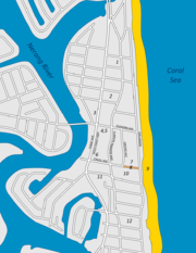
and onto the Gold Coast Broadwater
Gold Coast Broadwater
The Gold Coast Broadwater, also known as Southport Broadwater and Gold Coast Harbour, is a large shallow estuary of water reaching from the locality of Southport to the southern section of the World Heritage Listed Moreton Bay along the eastern coast of Australia...
at Southport
Southport, Queensland
-Sport:The Southport Sharks Australian rules football club has a presence in the area, including a club and function centre.-Transport:The Broadwaterway is a foreshoreway that encourages pedestrians and cyclists to travel along the Broadwater foreshores of Southport.A ferry terminal is planned for...
on the Gold Coast
Gold Coast, Queensland
Gold Coast is a coastal city of Australia located in South East Queensland, 94km south of the state capital Brisbane. With a population approximately 540,000 in 2010, it is the second most populous city in the state, the sixth most populous city in the country, and also the most populous...
.
The Nerang River catchment covers an area of 490 km², with it only covering 250 km.
Name
The river was initially named the River Barrow by government surveyor Robert DixonRobert Dixon (explorer)
Robert Dixon was an Australian surveyor and explorer, born in Darlington, England.-Arrival in Tasmania:Dixon arrived in Tasmania in May 1821 with his brother George...
when he charted the Gold Coast in 1840, after Sir John Barrow
Sir John Barrow, 1st Baronet
Sir John Barrow, 1st Baronet, FRS, FRGS was an English statesman.-Career:He was born the son of Roger Barrow in the village of Dragley Beck, in the parish of Ulverston then in Lancashire, now in Cumbria...
, Secretary of the Admiralty. The surveyor general Thomas Mitchell later changed many places to Aboriginal names, and this included giving the Nerang River its present name. Neerang is a Yugambeh
Yugambeh language
Yugambeh is an Australian aboriginal language spoken by the Yugambeh Bundjalung people living on the South-East Queensland coast between the Logan River and the Tweed River ....
word meaning "little shark" or "shovel-nosed shark". But the local aboriginal people in fact called the river Mogumbin or Been-goor-abee. And the peoples of the Tweed called it Talgai.
Dams
On the Nerang river is the Hinze DamHinze Dam
The Hinze Dam, also known as Advancetown Lake, supplies most of the water provided to Gold Coast City in Queensland, Australia. Some water is drawn from Little Nerang Dam and until recently northern suburbs received water from Wivenhoe Dam. It was completed in 1976 and expanded in 1989. Advancetown...
, creating Advancetown Lake, the Gold Coast's main water supply. Hinze Dam has had a significant flood mitigation effect. An older dam, higher up in the catchment
Drainage basin
A drainage basin is an extent or an area of land where surface water from rain and melting snow or ice converges to a single point, usually the exit of the basin, where the waters join another waterbody, such as a river, lake, reservoir, estuary, wetland, sea, or ocean...
and now called the Little Nerang Dam
Little Nerang Dam
The Little Nerang Dam is a secondary source of water supply to Gold Coast City in Queensland, Australia. It was completed in 1962 and is managed by Gold Coast Water. It is located on the Little Nerang Creek directly upstream from the Hinze Dam. Its catchment includes the Springbrook Plateau...
was an earlier water supply for the Gold Coast. The dams are managed by Gold Coast Water
Gold Coast Water
Allconnex Water is the water and wastewater business for the Gold Coast, Logan and Redland districts. It was established on 1 July 2010 under the Queensland State Government’s South East Queensland Water Reform...
Surfers Riverwalk
Surfers Paradise, Queensland
Surfers Paradise is a suburb on the Gold Coast in Queensland, Australia. At the 2006 Census, Surfers Paradise had a population of 18,501....
Riverwalk
Riverwalk
Riverwalk is a name often given to a foreshoreway or pedestrian zone adjacent to a river.Some famous examples of riverwalks are:-In the United States:* Riverwalk in Fort Lauderdale, Florida* Tampa Riverwalk in Tampa, Florida...
. The route would connect the Gold Coast Highway
Gold Coast Highway
The Gold Coast Highway in Queensland, Australia links the coastal suburbs of the Gold Coast. 33 km in length, the highway passes through popular tourist resorts such as Southport, Surfers Paradise, Burleigh Heads and Currumbin...
Bridge crossing of the Nerang River at Main Beach
Main Beach, Queensland
Main Beach is a suburb on the Gold Coast in Queensland, Australia. At the 2006 Census, Main Beach had a population of 3,324....
to Pacific Fair Shopping Centre
Pacific Fair Shopping Centre
Pacific Fair is a major shopping centre located in Broadbeach on the Gold Coast, Queensland, and was Queensland's largest regional shopping centre until 2006....
at Broadbeach
Broadbeach, Queensland
Broadbeach is a suburb on the Gold Coast, in Queensland, Australia. At the 2006 Census, Broadbeach had a population of 3,791.Development in the area today mostly incorporates low rise structures, consisting of single bedroom houses and apartment blocks...
. The route includes
- The western facing beaches of Main BeachMain Beach, QueenslandMain Beach is a suburb on the Gold Coast in Queensland, Australia. At the 2006 Census, Main Beach had a population of 3,324....
- The anabranch foreshores of McIntosh Island.
- Jaraparilla Cove
- The MarriottMarriott InternationalMarriott International, Inc. is a worldwide operator and franchisor of a broad portfolio of hotels and related lodging facilities. Founded by J. Willard Marriott, the company is now led by son J.W. Marriott, Jr...
Hotel boardwalk - Budds Beach
- Surfers Central Riverwalk from Budds Beach to Lionel Perry Park
- The Paradise Island anabranch
- Cannes Avenue Reach of the Nerang River
- Cascade Gardens foreshores of Little Tallebudgera Creek
- Gold Coast Convention and Exhibition CentreGold Coast Convention and Exhibition CentreThe Gold Coast Convention and Exhibition Centre located on the Gold Coast Highway in Broadbeach, Gold Coast was opened on 29 June 2004 at a cost of $167 million and is linked by a covered walkway to Conrad Jupiters...
boardwalk - Jupiters CasinoConrad JupitersJupiters Hotel and Casino was Queensland's first casino and hotel complex, which is located in the suburb of Broadbeach on the Gold Coast in Queensland, Australia. The casino is situated next to the Nerang River and is operated by Echo Entertainment Group...
Island foreshores - Pacific Fair Shopping CentrePacific Fair Shopping CentrePacific Fair is a major shopping centre located in Broadbeach on the Gold Coast, Queensland, and was Queensland's largest regional shopping centre until 2006....
Boatramps
Nerang River Boatramps open to the public are located at Waterways Drive at Main Beach, Budds Beach, Evandale, on the Isle of Capri, TE Peters Drive at Broadbeach Waters (Convention Centre), Carrara Road, CarraraCarrara, Queensland
Carrara is a suburb on the Gold Coast in Queensland, Australia, located on the southern bank of the Nerang River. At the 2006 Census, Carrara had a population of 10,687....
,and at the Nerang River Parklands.
External links
- Nerang page at the Gold Coast City Council
- The History of the Gold Coast at reflections.com.au