

Spring Creek, Nevada
Encyclopedia
Spring Creek is a census-designated place
(CDP) in central Elko County
, in northeastern Nevada
in the western United States
. It mainly serves as a bedroom community
for the businesses and industries in and around the nearby city of Elko
. It is part of the Elko Micropolitan Statistical Area
. The population was 12,361 at the 2010 census.
to the southeast. To the southwest is Huntington Valley and the South Fork of the Humboldt River
, while to the north is the main branch of the Humboldt
. The city of Elko is approximately 6 miles (9.7 km) to the northwest, while Lamoille
is just to the east. According to the United States Census Bureau
, the CDP has a total area of 58.7 square miles (152 km²).
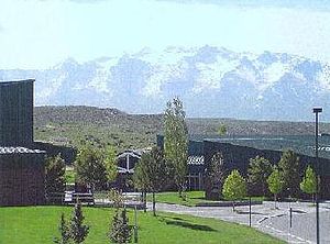
 The community was developed in the 1970s by Robert P. McCulloch as three large housing sections. The western section, at the base of the Elko Hills, is located near the post office (zip 89815), a shopping center, and a supermarket. About 1 mile to the east is the main school campus for grades 1-12. The central section of the community, another mile to the east, includes a park and lake ("The Marina"), and an 18-hole golf course and clubhouse. Nearby are an outdoor sports complex and a second elementary school. The southern section of the community surrounds an indoor sports arena ("The Horse Palace"), and is adjacent to the Ruby Mountains and a community-owned campground. All three sections are connected by the 4-lane Lamoille Highway
, which also crosses 5765-foot (1757 m) Lamoille Summit to connect with Elko.
of 2010, there were 12,361 people, 4,204 households, and 3,425 families residing in the CDP. The population density
was 179.8 per square mile (69.4/km²). There were 4,394 housing units at an average density of 62.4 per square mile (24.1/km²). The racial makeup of the CDP was 92.5% White, 0.3% African American, 1.6% Native American, 0.6% Asian, 0.1% Pacific Islander, 2.3% from other races
, and 2.6% from two or more races. Hispanic or Latino of any race were 7.8% of the population.
There were 4,204 households out of which 44.1% had children under the age of 18 living with them, 75.2% were married couples
living together, 4.7% had a female householder with no husband present, and 15.0% were non-families. 11.0% of all households were made up of individuals and 1.6% had someone living alone who was 65 years of age or older. The average household size was 3.10 and the average family size was 3.35.
In the CDP the population was spread out with 35.1% under the age of 18, 6.0% from 18 to 24, 33.5% from 25 to 44, 22.1% from 45 to 64, and 3.2% who were 65 years of age or older. The median age was 32 years. For every 100 females there were 105.0 males. For every 100 females age 18 and over, there were 104.9 males.
The median income for a household in the CDP was $60,109, and the median income for a family was $61,650. Males had a median income of $50,053 versus $27,260 for females. The per capita income
for the CDP was $20,606. About 2.9% of families and 4.2% of the population were below the poverty line, including 2.7% of those under age 18 and 8.2% of those age 65 or over.
Census-designated place
A census-designated place is a concentration of population identified by the United States Census Bureau for statistical purposes. CDPs are delineated for each decennial census as the statistical counterparts of incorporated places such as cities, towns and villages...
(CDP) in central Elko County
Elko County, Nevada
-Demographics:As of the census of 2000, there were 45,291 people, 15,638 households, and 11,493 families residing in the county. The population density was 3/sq mi . There were 18,456 housing units at an average density of 1/sq mi...
, in northeastern Nevada
Nevada
Nevada is a state in the western, mountain west, and southwestern regions of the United States. With an area of and a population of about 2.7 million, it is the 7th-largest and 35th-most populous state. Over two-thirds of Nevada's people live in the Las Vegas metropolitan area, which contains its...
in the western United States
United States
The United States of America is a federal constitutional republic comprising fifty states and a federal district...
. It mainly serves as a bedroom community
Commuter town
A commuter town is an urban community that is primarily residential, from which most of the workforce commutes out to earn their livelihood. Many commuter towns act as suburbs of a nearby metropolis that workers travel to daily, and many suburbs are commuter towns...
for the businesses and industries in and around the nearby city of Elko
Elko, Nevada
Elko is a city in Elko County, Nevada, United States. The population was 18,297 at the 2010 census. It is the county seat of Elko County. The city straddles the Humboldt River....
. It is part of the Elko Micropolitan Statistical Area
Elko micropolitan area
The Elko Micropolitan Statistical Area is a two county Nevada statistical area of . The area includes portions of the Humboldt River Basin , the Snake River Basin , and the Central Nevada Desert Basins subregion ....
. The population was 12,361 at the 2010 census.
Geography
Spring Creek is located in a large valley between the Elko Hills to the northwest, and the Ruby MountainsRuby Mountains
The Ruby Mountains comprise one of the many mountain ranges of the Great Basin in the western United States. They are the predominant range in Elko County, in the northeastern section of the state of Nevada. To the north is Secret Pass and the East Humboldt Range, and from there the Rubies run...
to the southeast. To the southwest is Huntington Valley and the South Fork of the Humboldt River
South Fork Humboldt River
The South Fork of the Humboldt River has its origins in a fan-shaped group of canyons draining the western slopes of the Ruby Mountains in northeastern Nevada. These headwaters run from Ruby Dome south to King Peak, and include Echo, Box, Kleckner, North Furlong, Long, Segunda, Drown, and...
, while to the north is the main branch of the Humboldt
Humboldt River
The Humboldt River runs through northern Nevada in the western United States. At approximately long it is the second longest river in the Great Basin, after the Bear River. It has no outlet to the ocean, but instead empties into the Humboldt Sink...
. The city of Elko is approximately 6 miles (9.7 km) to the northwest, while Lamoille
Lamoille, Nevada
Lamoille is a rural unincorporated community in Elko County in the northeastern section of the state of Nevada in the western United States. It is located about east of Elko at the base of the Ruby Mountains at an elevation of and is part of the Elko Micropolitan Statistical Area.The early...
is just to the east. According to the United States Census Bureau
United States Census Bureau
The United States Census Bureau is the government agency that is responsible for the United States Census. It also gathers other national demographic and economic data...
, the CDP has a total area of 58.7 square miles (152 km²).
Nevada State Route 227
State Route 227, commonly known as Lamoille Highway, is a state highway in Elko County, in northeastern Nevada in the western United States. From its terminus with State Route 535, it connects the city of Elko with the nearby communities of Spring Creek and Lamoille, to the southeast. For most...
, which also crosses 5765-foot (1757 m) Lamoille Summit to connect with Elko.
Demographics
As of the censusCensus
A census is the procedure of systematically acquiring and recording information about the members of a given population. It is a regularly occurring and official count of a particular population. The term is used mostly in connection with national population and housing censuses; other common...
of 2010, there were 12,361 people, 4,204 households, and 3,425 families residing in the CDP. The population density
Population density
Population density is a measurement of population per unit area or unit volume. It is frequently applied to living organisms, and particularly to humans...
was 179.8 per square mile (69.4/km²). There were 4,394 housing units at an average density of 62.4 per square mile (24.1/km²). The racial makeup of the CDP was 92.5% White, 0.3% African American, 1.6% Native American, 0.6% Asian, 0.1% Pacific Islander, 2.3% from other races
Race (United States Census)
Race and ethnicity in the United States Census, as defined by the Federal Office of Management and Budget and the United States Census Bureau, are self-identification data items in which residents choose the race or races with which they most closely identify, and indicate whether or not they are...
, and 2.6% from two or more races. Hispanic or Latino of any race were 7.8% of the population.
There were 4,204 households out of which 44.1% had children under the age of 18 living with them, 75.2% were married couples
Marriage
Marriage is a social union or legal contract between people that creates kinship. It is an institution in which interpersonal relationships, usually intimate and sexual, are acknowledged in a variety of ways, depending on the culture or subculture in which it is found...
living together, 4.7% had a female householder with no husband present, and 15.0% were non-families. 11.0% of all households were made up of individuals and 1.6% had someone living alone who was 65 years of age or older. The average household size was 3.10 and the average family size was 3.35.
In the CDP the population was spread out with 35.1% under the age of 18, 6.0% from 18 to 24, 33.5% from 25 to 44, 22.1% from 45 to 64, and 3.2% who were 65 years of age or older. The median age was 32 years. For every 100 females there were 105.0 males. For every 100 females age 18 and over, there were 104.9 males.
The median income for a household in the CDP was $60,109, and the median income for a family was $61,650. Males had a median income of $50,053 versus $27,260 for females. The per capita income
Per capita income
Per capita income or income per person is a measure of mean income within an economic aggregate, such as a country or city. It is calculated by taking a measure of all sources of income in the aggregate and dividing it by the total population...
for the CDP was $20,606. About 2.9% of families and 4.2% of the population were below the poverty line, including 2.7% of those under age 18 and 8.2% of those age 65 or over.