
Sprengisandur
Encyclopedia
Sprengisandur is a highland gravel road
in Iceland
, running between the glaciers Hofsjökull
and Vatnajökull
. The name also refers to the highland region surrounding the road.
 The same name is borne by a very remote airfield with two runways near (but not connected to) the Sprengisandur road in the highlands (ICAO: BISP)
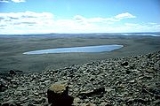
With its 200 km, the Sprengisandur highland road is the longest of the Icelandic highland roads. Its southern end is at the lake Þórisvatn
, to the northeast of the volcano Hekla
, and its northern end is the lower part of the valley of the river Skjálfandafljót
, to the southwest of lake Mývatn
.
and the Kaldidalur
highland routes, Sprengisandur is an ancient road - during the time of Icelandic Free State (ca. 930-1265) is was one of the several important north-south routes that connected remote regions of the island to the Plains of the Parliament, Þingvellir
, where the yearly parliament, Alþingi, was held each year at midsummer. In the sagas of Icelanders it is often called simply Sandr "sand" or Sandleið, "Sand trail". At its southern end, Sprengisandur joined another such route, Fjallabaksvegur nyrðri, running west from Landmannalaugar
mountain hot springs area. Sprengisandur was (and is) only used during summer - like all other roads crossing the inner desert, it was impassable in winter because of the snow, and in spring because of the floods. While being the shortest way to the Alþingi for some Icelanders, for example, those living around lake Ljósavatn that is very close to the northern end of the route, and for inhabitants of Vopnafjörður
, it had the downside of having by far the longest stretch through the forbidding inner desert regions among the other possible routes. For hundreds of kilometers, there was no fodder for horses to be had, and no human habitation to take shelter in. This feature gave the route its name: it is derived from Icelandic noun sandur "sand", which denotes volcanic ash deserts of the center of the island, and the verb sprengja that means "to ride a horse to death; to be on the point of bursting after running for too long".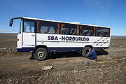 One needed to ride as fast as possible, nearly driving the horses to death, to cross the mountain desert and reach the inhabited regions of the island again before one ran out of victuals.
Hence, Sprengisandur was, if at all possible, avoided by medieval Icelanders, even if it meant taking the longer route. One example is in ch. 8 of the Hrafnkels saga
: the chieftain Hrafnkell, who lived in the East Fjords and rather close to the northern end of Sprengisandur, prefers to travel to the Alþingi by going south along the shore of the island - his route is much longer and slower, but it goes all the way through inhabited regions. His enemies, living in the same neighbourhood but needing speed, decide to take the shorter yet more exhausting Spregisandur route, so as to arrive at the Alþingi much earlier and have enough time to whip up some support for their case. Another example is in Ölkofra þáttr, where the chieftain Broddi, who lives in Vopnafjörður
, returns home from Alþingi by taking the Kjölur
route north and then going east along the northern shore of the island - a much longer road home than one through Sprengisandur, yet one going all the way through inhabited regions.
As usual with uninhabited places in Iceland, Sprengisandur route was considered to be haunted by ghosts. Both themes, the difficulty of passage and the presence of ghosts, are referred to in the famous Icelandic song Á Sprengisandi, written by Grímur Thomsen
(1820-1896).
to Mývatn
and back in July and August. If the weather is good, the route offers stunning views of both glaciers and volcanoes Askja
and Herðubreið
. In the middle of the track there is a small oasis with a hut of the Icelandic Hiking Club: Nýidalur.
Gravel road
A gravel road is a type of unpaved road surfaced with gravel that has been brought to the site from a quarry or stream bed. They are common in less-developed nations, and also in the rural areas of developed nations such as Canada and the United States. In New Zealand, they are known as 'metal roads'...
in Iceland
Iceland
Iceland , described as the Republic of Iceland, is a Nordic and European island country in the North Atlantic Ocean, on the Mid-Atlantic Ridge. Iceland also refers to the main island of the country, which contains almost all the population and almost all the land area. The country has a population...
, running between the glaciers Hofsjökull
Hofsjökull
Hofsjökull is the third largest glacier in Iceland after Vatnajökull and Langjökull and the largest active volcano in the country. It situates at the west of the Highlands of Iceland and north of the mountain range Kerlingarfjöll, between the two largest glaciers of Iceland. It covers an area of...
and Vatnajökull
Vatnajökull
Vatnajökull is the largest glacier in Iceland. It is located in the south-east of the island, covering more than 8% of the country.-Size:With an area of 8,100 km², Vatnajökull is the largest ice cap in Europe by volume and the second largest in area Vatnajökull is the largest glacier in...
. The name also refers to the highland region surrounding the road.
With its 200 km, the Sprengisandur highland road is the longest of the Icelandic highland roads. Its southern end is at the lake Þórisvatn
Þórisvatn
Þórisvatn, is the largest lake of Iceland, situated at the south end of Sprengisandur highland road within the highlands of Iceland.It is a reservoir of a surface about 88 km² and uses the energy of the river Þjórsá, which comes down from the glacier Hofsjökull. Here in the south, it is exploited...
, to the northeast of the volcano Hekla
Hekla
Hekla is a stratovolcano located in the south of Iceland with a height of . Hekla is one of Iceland's most active volcanoes; over 20 eruptions have occurred in and around the volcano since 874. During the Middle Ages, Icelanders called the volcano the "Gateway to Hell."Hekla is part of a volcanic...
, and its northern end is the lower part of the valley of the river Skjálfandafljót
Skjálfandafljót
The River Skjálfandafljót is situated in the north of Iceland.It has its source at the northwestern border of the icecap Vatnajökull on the Highlands of Iceland...
, to the southwest of lake Mývatn
Mývatn
Mývatn is a shallow eutrophic lake situated in an area of active volcanism in the north of Iceland, not far from Krafla volcano. The lake and its surrounding wetlands have an exceptionally rich fauna of waterbirds, especially ducks...
.
History and etymology
Like the KjölurKjölur
The Kjölur is a highland road in Iceland. It is the second longest of the roads through the Highlands of Iceland. It takes about 5 hours to traverse by car.- Geography :...
and the Kaldidalur
Kaldidalur
The Kaldidalsvegur is the shortest of the highland tracks traversing the Highlands of Iceland, therefore the nickname "highlands for beginners". Its name derives from the valley it crosses: kaldidalur means "cold dale/valley"...
highland routes, Sprengisandur is an ancient road - during the time of Icelandic Free State (ca. 930-1265) is was one of the several important north-south routes that connected remote regions of the island to the Plains of the Parliament, Þingvellir
Þingvellir
|Thing]] Fields) is a place in Bláskógabyggð in southwestern Iceland, near the peninsula of Reykjanes and the Hengill volcanic area. Þingvellir is a site of historical, cultural, and geological importance and is one of the most popular tourist destinations in Iceland. It is the site of a rift...
, where the yearly parliament, Alþingi, was held each year at midsummer. In the sagas of Icelanders it is often called simply Sandr "sand" or Sandleið, "Sand trail". At its southern end, Sprengisandur joined another such route, Fjallabaksvegur nyrðri, running west from Landmannalaugar
Landmannalaugar
Landmannalaugar is a region near the volcano Hekla in southern section of Iceland's highlands.The Landmannalaugar area is a popular tourist destination and hiking hub in Iceland's highlands. The area displays a number of unusual geological elements, like the multicolored rhyolite mountains and...
mountain hot springs area.
Vopnafjörður
Vopnafjörður is a village and municipality in Northeast Iceland, standing on a peninsula in the middle of a mountainous bay by the same name. The main industries of Vopnafjordur are fish processing, agriculture, and tourism and other services....
, it had the downside of having by far the longest stretch through the forbidding inner desert regions among the other possible routes. For hundreds of kilometers, there was no fodder for horses to be had, and no human habitation to take shelter in. This feature gave the route its name: it is derived from Icelandic noun sandur "sand", which denotes volcanic ash deserts of the center of the island, and the verb sprengja that means "to ride a horse to death; to be on the point of bursting after running for too long".
Hence, Sprengisandur was, if at all possible, avoided by medieval Icelanders, even if it meant taking the longer route. One example is in ch. 8 of the Hrafnkels saga
Hrafnkels saga
Hrafnkels saga or Hrafnkels saga Freysgoða is one of the Icelanders' sagas. It tells of struggles between chieftains and farmers in the east of Iceland in the 10th century. The eponymous main character, Hrafnkell, starts out his career as a fearsome duelist and a dedicated worshiper of the god...
: the chieftain Hrafnkell, who lived in the East Fjords and rather close to the northern end of Sprengisandur, prefers to travel to the Alþingi by going south along the shore of the island - his route is much longer and slower, but it goes all the way through inhabited regions. His enemies, living in the same neighbourhood but needing speed, decide to take the shorter yet more exhausting Spregisandur route, so as to arrive at the Alþingi much earlier and have enough time to whip up some support for their case. Another example is in Ölkofra þáttr, where the chieftain Broddi, who lives in Vopnafjörður
Vopnafjörður
Vopnafjörður is a village and municipality in Northeast Iceland, standing on a peninsula in the middle of a mountainous bay by the same name. The main industries of Vopnafjordur are fish processing, agriculture, and tourism and other services....
, returns home from Alþingi by taking the Kjölur
Kjölur
The Kjölur is a highland road in Iceland. It is the second longest of the roads through the Highlands of Iceland. It takes about 5 hours to traverse by car.- Geography :...
route north and then going east along the northern shore of the island - a much longer road home than one through Sprengisandur, yet one going all the way through inhabited regions.
As usual with uninhabited places in Iceland, Sprengisandur route was considered to be haunted by ghosts. Both themes, the difficulty of passage and the presence of ghosts, are referred to in the famous Icelandic song Á Sprengisandi, written by Grímur Thomsen
Grímur Thomsen
Grímur Thomsen , Icelandic poet and editor, was born in Bessastaðir in 1820. He was the son of Þorgrímur Tómasson, a goldsmith. In 1837, he went to the University of Copenhagen, where he studied law and philology, but he also became interested in philosophy and aesthetics...
(1820-1896).
Present-day use
After the loss of independence in 1265, the route gradually fell out of use, and was lost for many centuries, until in was again traced in 19th century. The modern gravel road goes more or less parallel and a bit south-east of the ancient horse trail. A tourist bus runs over the Sprengisandur every other day from LandmannalaugarLandmannalaugar
Landmannalaugar is a region near the volcano Hekla in southern section of Iceland's highlands.The Landmannalaugar area is a popular tourist destination and hiking hub in Iceland's highlands. The area displays a number of unusual geological elements, like the multicolored rhyolite mountains and...
to Mývatn
Mývatn
Mývatn is a shallow eutrophic lake situated in an area of active volcanism in the north of Iceland, not far from Krafla volcano. The lake and its surrounding wetlands have an exceptionally rich fauna of waterbirds, especially ducks...
and back in July and August. If the weather is good, the route offers stunning views of both glaciers and volcanoes Askja
Askja
Askja is a stratovolcano situated in a remote part of the central highlands of Iceland. The name Askja refers to a complex of nested calderas within the surrounding Dyngjufjöll mountains, which rise to , askja meaning box or caldera in Icelandic-Location:The region is only accessible for a few...
and Herðubreið
Herðubreið
Herðubreið is a tuya in north-east Iceland. It is situated in the Highlands of Iceland in the midst of the Ódáðahraun desert and close to Askja volcano. The desert is a large lava field originating from eruptions of Trölladyngja...
. In the middle of the track there is a small oasis with a hut of the Icelandic Hiking Club: Nýidalur.