
Southern Ports Highway
Encyclopedia
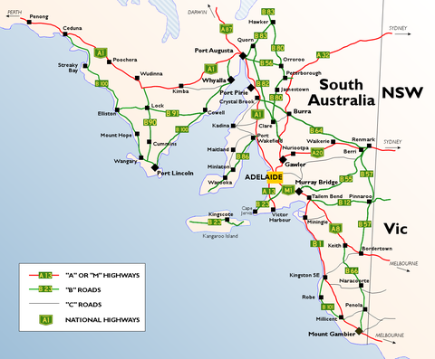
The Southern Ports Highway is a 117 kilometre highway in South Australia
that connects Kingston SE
with Millicent
via Rendelsham
, Southend
, Beachport
and Robe
. It is of good standard and is about 100 km long and was fully sealed in 1978. It was originally part of Highway 1, but is now designated B101. It was the original route of the Princes Highway
(until 1933) between Kingston SE and Millicent.
South Australia
South Australia is a state of Australia in the southern central part of the country. It covers some of the most arid parts of the continent; with a total land area of , it is the fourth largest of Australia's six states and two territories.South Australia shares borders with all of the mainland...
that connects Kingston SE
Kingston SE, South Australia
Kingston SE is a town approximately 297 km southeast of Adelaide, the capital of South Australia, and 44 km from the town of Robe. It is at the southeastern end of Encounter Bay and the Coorong. At the 2006 census, Kingston SE had a population of 1,443.-History:The town was named after...
with Millicent
Millicent, South Australia
Millicent is a town in South Australia, south-east of Adelaide, and north of Mount Gambier. At the 2006 Census, the population was 4,771.The town is home to the Millicent National Trust Museum, and is nearby to the Tantanoola Caves Conservation Park and the Canunda National Park.The Millicent...
via Rendelsham
Rendelsham, South Australia
Rendelsham is a town in the south east of South Australia, south east of the state capital, Adelaide....
, Southend
Southend, South Australia
Southend is a settlement in South Australia. At the 2006 census, Southend had a population of 560....
, Beachport
Beachport, South Australia
Beachport is a small coastal town 379 kilometres south-east of Adelaide, South Australia, located in the Wattle Range Council. Known for its 772 metre long jetty , Beachport is located on the northern end of Rivoli Bay...
and Robe
Robe, South Australia
Robe is a town and fishing port on the South East Limestone Coast of South Australia. The town's distinctive combination of historical buildings, ocean, fishing fleets, lakes and dense bush is widely appreciated. Robe lies on the southern shore of Guichen Bay, just off the Princes Highway. At the...
. It is of good standard and is about 100 km long and was fully sealed in 1978. It was originally part of Highway 1, but is now designated B101. It was the original route of the Princes Highway
Princes Highway
The Princes Highway extends from Sydney to Port Augusta via the coast through the states of New South Wales, Victoria and South Australia, a distance of 1941 km or 1898 km via the former alignments of the highway ....
(until 1933) between Kingston SE and Millicent.