

South Fork, Missouri
Encyclopedia
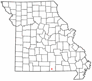
South Fork is a small unincorporated community
Unincorporated area
In law, an unincorporated area is a region of land that is not a part of any municipality.To "incorporate" in this context means to form a municipal corporation, a city, town, or village with its own government. An unincorporated community is usually not subject to or taxed by a municipal government...
in Howell County
Howell County, Missouri
Howell County is a county located in South Central Missouri in the United States. As of the 2010 U.S. Census, the county's population was 40,400. The largest city and county seat is West Plains...
, Missouri
Missouri
Missouri is a US state located in the Midwestern United States, bordered by Iowa, Illinois, Kentucky, Tennessee, Arkansas, Oklahoma, Kansas and Nebraska. With a 2010 population of 5,988,927, Missouri is the 18th most populous state in the nation and the fifth most populous in the Midwest. It...
, United States
United States
The United States of America is a federal constitutional republic comprising fifty states and a federal district...
. It is located ten miles west of West Plains
West Plains, Missouri
West Plains is a city in Howell County, Missouri, United States. The population was 10,866 at the 2000 census. It is the county seat of Howell County. The West Plains Micropolitan Statistical Area consists of Howell County.-Geography:...
on U.S. Route 160
U.S. Route 160
U.S. Route 160 is a 1,465 mile long east–west United States highway in the Midwestern United States. The western terminus of the route is at U.S. Route 89 five miles west of Tuba City, Arizona. The eastern terminus is at U.S...
. It was named for the South Fork of the Spring River, the location of the town. Previously, it had been named "Cross Roads".