

South Fambridge
Encyclopedia
South Fambridge is a village
in Essex
, England
. It is located about 300 yards (0.17 miles) from the River Crouch
. The village lies within the Rochford district
and the parliamentary constituency of Rayleigh
. Surrounded by farmland, it is reached by the Fambridge Road, approximately 1.5 miles from the main Ashingdon
Road.
 The village once had a small airfield which no longer exists, having been converted into a residential estate named Pemberton Field after Noel Pemberton Billing
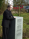
. On 20 February 2009 it was the 100th anniversary of the first experimental flights beside the River Crouch
meadows. Kenneth Bannerman, Director General of the Airfields of Britain Conservation Trust unveiled a memorial to the airfield. A Spitfire flown by Carolyn Grace took part in the Anniversary Commemoration, entertaining the crowd by carrying out some aerobatic manoeuvres. The Memorial is located at on the site of Brickhouse Farm.
Village
A village is a clustered human settlement or community, larger than a hamlet with the population ranging from a few hundred to a few thousand , Though often located in rural areas, the term urban village is also applied to certain urban neighbourhoods, such as the West Village in Manhattan, New...
in Essex
Essex
Essex is a ceremonial and non-metropolitan county in the East region of England, and one of the home counties. It is located to the northeast of Greater London. It borders with Cambridgeshire and Suffolk to the north, Hertfordshire to the west, Kent to the South and London to the south west...
, England
England
England is a country that is part of the United Kingdom. It shares land borders with Scotland to the north and Wales to the west; the Irish Sea is to the north west, the Celtic Sea to the south west, with the North Sea to the east and the English Channel to the south separating it from continental...
. It is located about 300 yards (0.17 miles) from the River Crouch
River Crouch
The River Crouch is a river that flows entirely through the English county of Essex.The distance of the Navigation between Holliwell Point which is north of Foulness Island and Battlesbridge is 17.5 Miles, i.e. 15.21 Nautical Miles.-Route:...
. The village lies within the Rochford district
Rochford (district)
Rochford is a local government district in Essex, England. It is named for one of its main settlements, Rochford, though the major centre of population in the district is the town of Rayleigh...
and the parliamentary constituency of Rayleigh
Rayleigh (UK Parliament constituency)
Rayleigh was a parliamentary constituency in Essex represented in the House of Commons of the Parliament of the United Kingdom. It elected one Member of Parliament by the first past the post system of election...
. Surrounded by farmland, it is reached by the Fambridge Road, approximately 1.5 miles from the main Ashingdon
Ashingdon
Ashingdon is a village and civil parish in Essex, England. It is located about north of Rochford and is southeast from the county town of Chelmsford...
Road.
Airfield
Noel Pemberton Billing
Noel Pemberton Billing was an English aviator, inventor, publisher, and Member of Parliament. He founded the firm that became Supermarine and promoted air power, but he held a strong antipathy towards the Royal Aircraft Factory and its products...
. On 20 February 2009 it was the 100th anniversary of the first experimental flights beside the River Crouch
River Crouch
The River Crouch is a river that flows entirely through the English county of Essex.The distance of the Navigation between Holliwell Point which is north of Foulness Island and Battlesbridge is 17.5 Miles, i.e. 15.21 Nautical Miles.-Route:...
meadows. Kenneth Bannerman, Director General of the Airfields of Britain Conservation Trust unveiled a memorial to the airfield. A Spitfire flown by Carolyn Grace took part in the Anniversary Commemoration, entertaining the crowd by carrying out some aerobatic manoeuvres. The Memorial is located at on the site of Brickhouse Farm.