

Sources of the Rhine
Encyclopedia
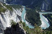
Rein da Tuma
The Rein da Tuma is a river in Switzerland, in the Canton of Graubünden. It rises east of the Rossbodenstock with two or three mountain streams, that flow across the Tuma Alp into the Lake Toma . Before they reach the lake, they flow through a plane and form small meanders...
and after a few kilometers, it forms the Vorderrhein
Vorderrhein
The Vorderrhein is one of the two sources of the Rhine. Its catchment area of is located predominantly in the Canton of Graubünden . The Vorderrhein is about long, thus more than 5% longer than the Hinterrhein...
(English: Anterior Rhine; Romansh: Rein Anteriur). The course of this river is not particularly representative, after about two kilometers, its water is diverted into Curnera
Lai da Curnera
Lai da Curnera is a reservoir in the municipality of Tujetsch, in the Grisons, Switzerland. The reservoir is linked to Lai da Sontga Maria and Lai da Nalps in the neighboring valley...
reservoir. The water is released at the Tavanase plant and flows into the Rhine at Ilanz
Ilanz
Ilanz is a municipality in the district of Surselva in the Swiss canton of Graubünden.-History:Ilanz is first mentioned in 765 as Iliande. Ilanz became the capital of the newly formed Grey League in 1395. The Grey League was the second of Three Leagues which eventually formed canton Graubünden...
. The river begins to be called Rhine in the vicinity of Chur
Chur
Chur or Coire is the capital of the Swiss canton of Graubünden and lies in the northern part of the canton.-History:The name "chur" derives perhaps from the Celtic kora or koria, meaning "tribe", or from the Latin curia....
, more specifically, at the confluence of the Vorderrhein
Vorderrhein
The Vorderrhein is one of the two sources of the Rhine. Its catchment area of is located predominantly in the Canton of Graubünden . The Vorderrhein is about long, thus more than 5% longer than the Hinterrhein...
and Hinterrhein (river)
Hinterrhein (river)
The Hinterrhein is one of the initial tributaries of the Rhine in the Canton of Graubünden in Switzerland, flowing from the village Hinterrhein near the San Bernardino pass through the Rheinwald valley into a gorge called Roflaschlucht...
in Reichenau.
Criteria for distinguishing between main branches and tributaries
There are different criteria for the definition of tributaries, and by some definitions, irrespective of the official name, one strand or another may be called the source. Determining the source of the Rhine is difficult, because in the river system of the Anterior and Posterior Rhine, there are many headwaters of similar size. Apart from the common criterion of the (apparent or real) larger discharge, ongoing cartographic research allows us to determine the headwater with the greatest length, the largest catchment area or (occasionally) the highest source.The direction of flow may be crucial to the nomenclature as may be the significance of the valleys as room for housing and transport. Both criteria are more appropriate to the Vorderrhein, since the Hinterrhein valley was hardly populated before the influx of the Walser
Walser
The Walser are German-speaking people who live in the Alps of Switzerland, Italy, Liechtenstein and Austria. The Walser people are named after the Wallis , the uppermost Rhône River valley...
.
Rhine sources by name
Swisstopo
Swisstopo is the official name for the Swiss Federal Office of Topography , Switzerland's national mapping agency.The current pseudo-English name was made official in 2002...
and ETH Zürich
ETH Zurich
The Swiss Federal Institute of Technology Zurich or ETH Zürich is an engineering, science, technology, mathematics and management university in the City of Zurich, Switzerland....
indicate a point North of Lake Toma and the Rein da Tuma
Rein da Tuma
The Rein da Tuma is a river in Switzerland, in the Canton of Graubünden. It rises east of the Rossbodenstock with two or three mountain streams, that flow across the Tuma Alp into the Lake Toma . Before they reach the lake, they flow through a plane and form small meanders...
as the source of the Rhine (and also of the Vorderrhein), and as the source of the Hinterrhein a point in the upper Rheinwald
Rheinwald
The Rheinwald is a valley in the Canton of Graubünden in Switzerland...
valley, East of the Rheinwaldhorn
Rheinwaldhorn
The Rheinwaldhorn is the highest point in the Swiss canton of Ticino at 3402m. It lies on the border between the cantons of Graubünden and Ticino, in the Adula massif, part of the St. Gotthard massif of the Lepontine Alps in southern Switzerland....
.
In the area of the headwaters of the Rhine there is this situation that the term Rhine is used is part of the name of many rivers, in many different spellings, such as Rhine,Rein, 'Rain, Ragn, Ren, Reno and Rin.
Source of the Rhine according to maximum discharge
If one were to use largest discharge as one's criterion for deciding which flow should be called Rhine, one need not look at eastern Switzerland at all, since the Aar has a larger discharge then the Rhine at the confluence. However, in the rest of this article, the Aar will be ignored.The source of the main flow path can be obtained by following the river upstream and determining at each junction which the larger river. At the confluence of the Vorderrhein and Hinterrhein (forming the Rhine) at Reichenau, the average of the Vorderrhein is 53.8 m³/s and the discharge of the Hinterrhein is somewhat larger at 59.6 m³/s. At the mouth of the Albula, in the natural state, the latter is larger than the Hinterrhein (29.1 m³/s for the Albula compared with 27.3 m³/s for the Hinterrhein). At the mouth of the Landwasser, the latter is significantly larger (9.45 m³/s compared to 5.57 m³/s). Among the headwaters of the Landwasser in the Davos
Davos
Davos is a municipality in the district of Prättigau/Davos in the canton of Graubünden, Switzerland. It has a permanent population of 11,248 . Davos is located on the Landwasser River, in the Swiss Alps, between the Plessur and Albula Range...
area, the Dischmabach
Dischmabach
The Dischmabach is a river of approximately 15 km long in the river system of Albula. It drains the Dischma valley, its catchment area lies mainly in the area of the Swiss municipality of Davos.The source Dischmabach has two equal headwaters...
is slightly larger than the Flüelabach, even if considering the former small tributary flowing out of Lake Davos
Lake Davos
Lake Davos is a small natural lake at Davos, Switzerland. Its surface area is 0.59 km² and the maximum depth is 54 m. Fed by Flüelabach, Totalpbach and other mountain creeks, the lake is used as a hydropower reservoir, its water no longer flows to the Landwasser River but is channeled into the...
. This implies that the hydrological main branch starts at the top of Dischma valley, far away from greater rivers bearing the name "Rhine".
The current values of the average discharge are rather different from the natural values, because many hydropower plants draw water from outside their natural catchment and this water bypasses some gauging stations. Water is retrieved from southern parts of the Vorderrhein watershed and released into the Hinterrhein, or taken from the Hinterrhein and released into the Albula, or taken from the Landwasser and Albula and released into the lower Hinterrhein (e.g. Albula-Landwasser Hydropower). In the upper Landwasser valley, water is retrieved from the Flüelabach and Davosersee and released in a neighbouring valley near Aeua in the Klosters
Klosters
Klosters-Serneus is a municipality in the district of Prättigau/Davos in the Swiss canton of Graubünden.Its well-known ski resort lies from Zurich, the nearest international airport. Transfer time is about 1.5 hours. Klosters is from Davos...
area.
Source of the Rhine by length
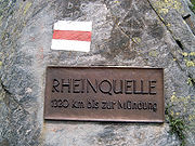
Near the "source of the Rhine" at Lake Toma, there is a well known sign with the (erroneous) information, "1320 km to the mouth" (it's only about 1230 km).The flow path from the source in the Lake Toma flowing through Rein da Tuma
Rein da Tuma
The Rein da Tuma is a river in Switzerland, in the Canton of Graubünden. It rises east of the Rossbodenstock with two or three mountain streams, that flow across the Tuma Alp into the Lake Toma . Before they reach the lake, they flow through a plane and form small meanders...
measures about 71 km to the confluence of the Vorderrhein and Hinterrhein. (From there it's more about 1160 km along the river to the North Sea
North Sea
In the southwest, beyond the Straits of Dover, the North Sea becomes the English Channel connecting to the Atlantic Ocean. In the east, it connects to the Baltic Sea via the Skagerrak and Kattegat, narrow straits that separate Denmark from Norway and Sweden respectively...
.) There are, however, in some longer flow paths in the Vorderrhein area. Measuring the longest path from the source to the confluence at Reichenau:
- About 76 km: Rein da MedelRein da MedelThe Rein da Medel is the longest headwater of the Rhine. It is located in the Swiss cantons of Ticino and Graubünden and flows trough the valleys Val Cadlimo and Val Medel. Rein da Medel is the local Sursilvan, The Rein da Medel is the longest headwater of the Rhine. It is located in the Swiss...
(the central part is also known as Froda; the headwaters in Ticino are known as Reno di Medel) - About 75 km: Rein da MaighelsRein da MaighelsThe Rein da Maighels is one of the main tributaries of the Rhine and is a tributary to the Rein da Curnera. The firm Kraftwerke Vorderrhein AG has built a hydropower dam creating a reservoir, called the Lai da Curnera, into which both rivers now flow.The origin of the Rein da Maighels is the...
(a tributary of the Rein da Curnera) - About 74 km: Rein da CurneraRein da CurneraThe Rein da Curnera is a right tributary of the Anterior Rhine and one of the main tributaries of the Rhine . It is fed from multiple sources and glaciers at the southern end of the valley. The river is about 8 kilometers long and flows north through the Val Curnera...
- About 71 km: Rein da TumaRein da TumaThe Rein da Tuma is a river in Switzerland, in the Canton of Graubünden. It rises east of the Rossbodenstock with two or three mountain streams, that flow across the Tuma Alp into the Lake Toma . Before they reach the lake, they flow through a plane and form small meanders...
(counting Lake Toma and the longest stream into the lake) - About 71 km: Rein da Nalps
- About 70 km: two unnamed streams descending from the Puozas und Milez ares close to the Oberalp PassOberalp PassOberalp Pass is a high mountain pass in the Swiss Alps connecting the cantons of Graubünden and Uri between Disentis and Andermatt.-Winter closure:...
- About 70 km: the Aua da Val,descending from the Val valley, which disappears under a moraine at a height of 2367m and reappears on a ledge some distance lower
- About 69.5 km: Aua da Urlaun, a tributary if the Rein da Tuma
The flow paths in the Hinterrheins tend to be slightly shorter:
- About 72 km: DischmabachDischmabachThe Dischmabach is a river of approximately 15 km long in the river system of Albula. It drains the Dischma valley, its catchment area lies mainly in the area of the Swiss municipality of Davos.The source Dischmabach has two equal headwaters...
- About 70 km: Flüelabach
- About 64 km: Hinterrhein
- About 64 km: Totalpbach (a former headwater of the Landwasser; now flows into Lake Davos and from there the water is artificially piped to Klosters)
- About 63 km: Julia
- About 61 km: Madrischer Rhine
- About 56 km: The Ava da Ravais, headwater of the Albula flows East from Bergün
- About 53 km: a headwater of the Albula descending from the Crap Alv Laiets near the Albula PassAlbula PassAlbula Pass is a Swiss mountain pass in the canton of Graubünden. It lies in the Albula Range of the Alps...
The longest headwater of both the Vorderrhein and the Rhine as a whole, therefore, is the Reno di Medel
Rein da Medel
The Rein da Medel is the longest headwater of the Rhine. It is located in the Swiss cantons of Ticino and Graubünden and flows trough the valleys Val Cadlimo and Val Medel. Rein da Medel is the local Sursilvan, The Rein da Medel is the longest headwater of the Rhine. It is located in the Swiss...
, rising about 7.5 km south of Lake Toma. Its spring and upper reaches are located West of the Lukmanier Pass
Lukmanier Pass
Lukmanier Pass is a pass in the Swiss Alps.The road from Disentis/Mustér in the canton of Graubünden leads through the Val Medel across the pass to the Blenio valley and Biasca in the canton of Ticino.The Pass is kept opened during the winter.-See also:* List of highest paved roads in Europe*...
in the minucipality of Quinto in Ticino.
Size of the catchment areas
The catchment area of the Vorderrhein covers about 1512 km²; the basin of the Hinterrhein (including the Albula and Landwasser), is slightly larger at 1693 km². The percentage of the precipitation that ends up flowing down the river is fairly similar in the valleys of the headwaters of the Rhine, so the size of the catchment area tends to be proportial to the average discharge, and therefore this criterion doesn't need to be considered separately.Summary
No clear hierarchy can be established among the headwaters of the Rhine. The two main system, the Vorderrhein in the West and the Hinterrhein in the South and East, differ only slightly in length, discharge and size of their catchment area.The longest paths begin in the upper Vorderrhein valley and the upper Landwasser valley, respectively the most western and the most eastern parts of the headwaters area. The source of the hydrological main path would be found in the east, in the valley of the Dischmabach.