
Soudan Underground Mine State Park
Encyclopedia
The Soudan Underground Mine State Park is a Minnesota
state park at the site of the Soudan Underground Mine, on the south shore of Lake Vermilion
. The mine is known as Minnesota's oldest, deepest, and richest iron mine
, and now hosts the Soudan Underground Laboratory. As the Soudan Iron Mine, it has been designated a U.S. National Historic Landmark
.
 In the late 19th century, prospectors searching for gold
in northern Minnesota discovered extremely rich veins of hematite
at this site, often containing more than 65% iron
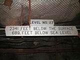
. An open pit mine began operation in 1882, and moved to underground mining by 1900 for safety reasons. From 1901 until the end of active mining in 1962, the Soudan Mine was owned by the United States Steel Corporation's Oliver Iron Mining division. By 1912 the mine was at a depth of 1,250 feet (381 m). When the mine closed, level 27 was being developed at 2,341 feet (713.5 m) below the surface and the entire underground workings consisted of more than fifty miles of drifts, adits, and raises. In 1965, US Steel donated the Soudan Mine to the State of Minnesota
to use for educational purposes.
The primary underground mining method used was known as cut and fill. This involved mining the ceiling and using Ely Greenstone and other waste rock to artificially raise the floor at the same rate as the ceiling was being mined out. As a result the floor and ceiling were always 10–20 feet (3–6 m) apart, and waste rock never had to be hauled to the surface, since it was recycled. This technique was particularly suited to the Soudan Mine due to the strength of the hematite formations and the weakness of the encasing Greenstone. This method was not possible in the nearby mines in Ely
because the iron formations there were fractured and thus were not as structurally stable as those in Soudan
.
, on the shore of Lake Vermilion
in northern Minnesota's Vermilion Range
. The mine is close to Minnesota State Highway 169
, about 20 miles east of Virginia
and 20 miles (30 km) west of Ely
, or about one mile from Tower
. It has become a popular tourist site, often visited on the way to and from Ely
and the Boundary Waters Canoe Area Wilderness
.
The state park is operated under the Department of Natural Resources
. It is a National Historic Landmark
, meaning that it is also listed on the National Register of Historic Places
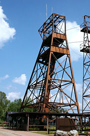
. The surface buildings are open to the public, and during the summer months there are daily tours of the mine. Visitors are lowered in an 80-year-old electric mine hoist to level 27, the mine's lowest level at 2,341 feet (713.5 m) below ground. Two tours are open to the public: one that explores the historic mining facilities, and another that focuses on the currently active underground physics laboratory.
 In the 1980s, scientists from the University of Minnesota
began to develop the Soudan Mine as a site for sensitive physics experiments because of the very low rate of cosmic rays in the deep underground site. The mine was originally home to the Soudan 1
proton decay
experiment and its successor, Soudan 2 which operated from 1989-2001. The University and the Department of Natural Resources
have since expanded the laboratory to accommodate other physics projects, such as the currently active MINOS
neutrino
detector, CDMS
-II, a dark matter
search experiment, and work on electro forming copper to create pure radiation free copper. Low-background materials screening facilities are in use and continuing development. The mine was proposed as one possible site for a U.S. Deep Underground Science and Engineering Laboratory
, but that project has since been awarded to the Homestake Mine (South Dakota)
. Parts of the laboratory are open for daily tours, and there is an annual open house with more access to the facilities and representatives of the experiments to help with the tours and answer questions.
Minnesota
Minnesota is a U.S. state located in the Midwestern United States. The twelfth largest state of the U.S., it is the twenty-first most populous, with 5.3 million residents. Minnesota was carved out of the eastern half of the Minnesota Territory and admitted to the Union as the thirty-second state...
state park at the site of the Soudan Underground Mine, on the south shore of Lake Vermilion
Lake Vermilion
Lake Vermilion is a freshwater lake in northeastern Minnesota, United States. The Ojibwe originally called the lake Onamuni, which means "Lake of the Sunset Glow". French fur traders translated this to the Latin word Vermilion, which is a red pigment...
. The mine is known as Minnesota's oldest, deepest, and richest iron mine
Mining
Mining is the extraction of valuable minerals or other geological materials from the earth, from an ore body, vein or seam. The term also includes the removal of soil. Materials recovered by mining include base metals, precious metals, iron, uranium, coal, diamonds, limestone, oil shale, rock...
, and now hosts the Soudan Underground Laboratory. As the Soudan Iron Mine, it has been designated a U.S. National Historic Landmark
National Historic Landmark
A National Historic Landmark is a building, site, structure, object, or district, that is officially recognized by the United States government for its historical significance...
.
History
Gold
Gold is a chemical element with the symbol Au and an atomic number of 79. Gold is a dense, soft, shiny, malleable and ductile metal. Pure gold has a bright yellow color and luster traditionally considered attractive, which it maintains without oxidizing in air or water. Chemically, gold is a...
in northern Minnesota discovered extremely rich veins of hematite
Hematite
Hematite, also spelled as haematite, is the mineral form of iron oxide , one of several iron oxides. Hematite crystallizes in the rhombohedral system, and it has the same crystal structure as ilmenite and corundum...
at this site, often containing more than 65% iron
Iron
Iron is a chemical element with the symbol Fe and atomic number 26. It is a metal in the first transition series. It is the most common element forming the planet Earth as a whole, forming much of Earth's outer and inner core. It is the fourth most common element in the Earth's crust...
. An open pit mine began operation in 1882, and moved to underground mining by 1900 for safety reasons. From 1901 until the end of active mining in 1962, the Soudan Mine was owned by the United States Steel Corporation's Oliver Iron Mining division. By 1912 the mine was at a depth of 1,250 feet (381 m). When the mine closed, level 27 was being developed at 2,341 feet (713.5 m) below the surface and the entire underground workings consisted of more than fifty miles of drifts, adits, and raises. In 1965, US Steel donated the Soudan Mine to the State of Minnesota
Minnesota
Minnesota is a U.S. state located in the Midwestern United States. The twelfth largest state of the U.S., it is the twenty-first most populous, with 5.3 million residents. Minnesota was carved out of the eastern half of the Minnesota Territory and admitted to the Union as the thirty-second state...
to use for educational purposes.
The primary underground mining method used was known as cut and fill. This involved mining the ceiling and using Ely Greenstone and other waste rock to artificially raise the floor at the same rate as the ceiling was being mined out. As a result the floor and ceiling were always 10–20 feet (3–6 m) apart, and waste rock never had to be hauled to the surface, since it was recycled. This technique was particularly suited to the Soudan Mine due to the strength of the hematite formations and the weakness of the encasing Greenstone. This method was not possible in the nearby mines in Ely
Ely, Minnesota
As of the census of 2000, there were 3,724 people, 1,912 households, and 916 families residing in the city. The population density was 1,369.5 people per square mile . There were 1,912 housing units at an average density of 703.2 per square mile...
because the iron formations there were fractured and thus were not as structurally stable as those in Soudan
Soudan, Minnesota
Soudan is an unincorporated community in Breitung Township, St. Louis County, Minnesota, United States.The community is located immediately east of the city of Tower on MN Highway 169 / MN Highway 1....
.
State Park
The park is in Breitung TownshipBreitung Township, Minnesota
Breitung Township is a township in St. Louis County, Minnesota, United States. The population was 605 at the 2010 census.Minnesota Highway 1 and Minnesota Highway 169 serve as the main arterial route in the township....
, on the shore of Lake Vermilion
Lake Vermilion
Lake Vermilion is a freshwater lake in northeastern Minnesota, United States. The Ojibwe originally called the lake Onamuni, which means "Lake of the Sunset Glow". French fur traders translated this to the Latin word Vermilion, which is a red pigment...
in northern Minnesota's Vermilion Range
Vermilion Range (Minnesota)
The Vermilion Range exists between Tower and Ely, Minnesota, and contains significant deposits of iron ore. The Vermilion, along with the Mesabi and Cuyuna Ranges, constitute the Iron Ranges of northern Minnesota which were deposited in the Animikie Group...
. The mine is close to Minnesota State Highway 169
Minnesota State Highway 169
Minnesota State Highway 169 is a highway in northeast Minnesota, which runs from its interchange with U.S. Highway 53 in Wuori Township and continues northeast to its northern terminus at the intersection of Lake County Road 18 and Power Dam Road in Fall Lake Township...
, about 20 miles east of Virginia
Virginia, Minnesota
As of the census of 2000, there were 9,157 people, 4,333 households, and 2,270 families residing in the city. The population density was 486.1 people per square mile . There were 4,692 housing units at an average density of 249.1 per square mile...
and 20 miles (30 km) west of Ely
Ely, Minnesota
As of the census of 2000, there were 3,724 people, 1,912 households, and 916 families residing in the city. The population density was 1,369.5 people per square mile . There were 1,912 housing units at an average density of 703.2 per square mile...
, or about one mile from Tower
Tower, Minnesota
As of the census of 2000, there are 479 people in the city, organized into 233 households and 137 families. The population density is 176.8 people per square mile . There are 295 housing units at an average density of 108.9 per square mile...
. It has become a popular tourist site, often visited on the way to and from Ely
Ely, Minnesota
As of the census of 2000, there were 3,724 people, 1,912 households, and 916 families residing in the city. The population density was 1,369.5 people per square mile . There were 1,912 housing units at an average density of 703.2 per square mile...
and the Boundary Waters Canoe Area Wilderness
Boundary Waters Canoe Area Wilderness
The Boundary Waters Canoe Area Wilderness , is a wilderness area within the Superior National Forest in northeastern Minnesota under the administration of the U.S. Forest Service...
.
The state park is operated under the Department of Natural Resources
Department of Natural Resources
Many sub-national governments have a Department of Natural Resources or similarly named organization:Australia*Queensland Department of Natural Resources and MinesCanada*Natural Resources Canada*New Brunswick**New Brunswick Department of Natural Resources...
. It is a National Historic Landmark
National Historic Landmark
A National Historic Landmark is a building, site, structure, object, or district, that is officially recognized by the United States government for its historical significance...
, meaning that it is also listed on the National Register of Historic Places
National Register of Historic Places
The National Register of Historic Places is the United States government's official list of districts, sites, buildings, structures, and objects deemed worthy of preservation...
. The surface buildings are open to the public, and during the summer months there are daily tours of the mine. Visitors are lowered in an 80-year-old electric mine hoist to level 27, the mine's lowest level at 2,341 feet (713.5 m) below ground. Two tours are open to the public: one that explores the historic mining facilities, and another that focuses on the currently active underground physics laboratory.
Underground Laboratory
University of Minnesota
The University of Minnesota, Twin Cities is a public research university located in Minneapolis and St. Paul, Minnesota, United States. It is the oldest and largest part of the University of Minnesota system and has the fourth-largest main campus student body in the United States, with 52,557...
began to develop the Soudan Mine as a site for sensitive physics experiments because of the very low rate of cosmic rays in the deep underground site. The mine was originally home to the Soudan 1
Soudan 1
Soudan 1 was a particle detector located in the Soudan Mine in Northern Minnesota, United States. It was a 30 ton iron tracking calorimeter whose primary purpose was to search for proton decay. It set a lower limit on the lifetime of the proton of 1.6×1030 years as well as upper limits on the...
proton decay
Proton decay
In particle physics, proton decay is a hypothetical form of radioactive decay in which the proton decays into lighter subatomic particles, such as a neutral pion and a positron...
experiment and its successor, Soudan 2 which operated from 1989-2001. The University and the Department of Natural Resources
Department of Natural Resources
Many sub-national governments have a Department of Natural Resources or similarly named organization:Australia*Queensland Department of Natural Resources and MinesCanada*Natural Resources Canada*New Brunswick**New Brunswick Department of Natural Resources...
have since expanded the laboratory to accommodate other physics projects, such as the currently active MINOS
MINOS
MINOS is a particle physics experiment designed to study the phenomena of neutrino oscillations, first discovered by a Super-Kamiokande experiment in 1998...
neutrino
Neutrino
A neutrino is an electrically neutral, weakly interacting elementary subatomic particle with a half-integer spin, chirality and a disputed but small non-zero mass. It is able to pass through ordinary matter almost unaffected...
detector, CDMS
Cryogenic Dark Matter Search
The Cryogenic Dark Matter Search is a series of experiments designed to directly detect particle dark matter in the form of WIMPs. Using an array of semiconductor detectors at millikelvin temperatures, CDMS has set the most sensitive limits to date on the interactions of WIMP dark matter with...
-II, a dark matter
Dark matter
In astronomy and cosmology, dark matter is matter that neither emits nor scatters light or other electromagnetic radiation, and so cannot be directly detected via optical or radio astronomy...
search experiment, and work on electro forming copper to create pure radiation free copper. Low-background materials screening facilities are in use and continuing development. The mine was proposed as one possible site for a U.S. Deep Underground Science and Engineering Laboratory
Deep Underground Science and Engineering Laboratory
The Deep Underground Science and Engineering Laboratory, or DUSEL is a major project under consideration by the National Science Foundation. DUSEL will be a series of large laboratories, caverns, and cleanrooms serving the field of underground science...
, but that project has since been awarded to the Homestake Mine (South Dakota)
Homestake Mine (South Dakota)
The Homestake Mine was a deep underground gold mine located in Lead, South Dakota. Until it closed in 2002 it was the largest and deepest gold mine in North America, producing more than 40 million ounces of gold. The Homestake Mine is famous in scientific circles for being the site at which the...
. Parts of the laboratory are open for daily tours, and there is an annual open house with more access to the facilities and representatives of the experiments to help with the tours and answer questions.
Tower/Soudan mine fire
A fire broke out late Thursday, March 17, 2011 in the main shaft at the 25 level. The fire was smothered using 70,000 gallons of foam. There is now an major cleanup of area around the bottom of the shaft (27th level), as it is filled with dense foam from floor to ceiling. The Underground Laboratory lost power but is safe. The mine tours are closed for the summer (2011) but above ground tours and interpretive center have been reopened.External links
- Soudan Underground Mine State Park
- National Register of Historic Places: Mines: Soudan Mine
- Soudan Underground Laboratory
- Deep Underground Science and Engineering Laboratory (proposed)
- Tower Soudan Historical Society
- NHL summary
- Cleanup underway at Soudan Mine Fire
- Scientists reenter Soudan Underground Laboratory