
Tioga Pass
Encyclopedia
Tioga Pass is a mountain pass
in the Sierra Nevada mountains of California
. State Route 120 runs through it, and serves as the eastern entry point for Yosemite National Park
. It is the highest highway pass in California and in the Sierra Nevada. Mount Dana
is to the east of the pass. There are several trailheads into the Yosemite backcountry which begin at Tioga Pass, including the trail to the Gaylor Lakes to the west/northwest, and the rough trail to the summit of Mount Dana
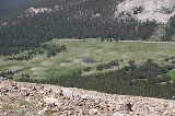
. Dana Meadows
is immediately south of the pass alongside the highway, as the pass itself is roughly angled north/south as opposed to east/west. Dana Meadows contains several small lakes.
This pass, like many other passes in the Sierra Nevada, has a gradual approach from the west and drops off to the east dramatically, losing more than 3,000 ft (914 m) by the time the road reaches U.S. Route 395.
Tioga Pass is named after Tioga Mine, whose name originated in New York
: "Tioga" is named for an Iroquois
and Mohawk
term meaning "where it forks".
The pass is subject to winter closure, due to high snowfall, normally from around the end of October until the end of May the following year, though these dates are subject to considerable variation. In heavy snow years, the road usually closes in early-October and could open as late as mid-July. In light snow years, the road could be closed in December and open as soon as April.
Tioga Pass is the most direct route from Bishop
or Mammoth Lakes, California
to Fresno
, Merced
, and Stockton
. There are four passes to the north, between Yosemite and Lake Tahoe
, but none to the south for about 200 miles (300 km), until Sherman Pass in southern Tulare County.
Mountain pass
A mountain pass is a route through a mountain range or over a ridge. If following the lowest possible route, a pass is locally the highest point on that route...
in the Sierra Nevada mountains of California
California
California is a state located on the West Coast of the United States. It is by far the most populous U.S. state, and the third-largest by land area...
. State Route 120 runs through it, and serves as the eastern entry point for Yosemite National Park
Yosemite National Park
Yosemite National Park is a United States National Park spanning eastern portions of Tuolumne, Mariposa and Madera counties in east central California, United States. The park covers an area of and reaches across the western slopes of the Sierra Nevada mountain chain...
. It is the highest highway pass in California and in the Sierra Nevada. Mount Dana
Mount Dana
Mount Dana is a mountain on the eastern edge of Yosemite National Park in the U.S. state of California. At an elevation of , it is the second highest mountain in Yosemite . Mount Dana is the highest peak in Yosemite that is a simple hike to the summit...
is to the east of the pass. There are several trailheads into the Yosemite backcountry which begin at Tioga Pass, including the trail to the Gaylor Lakes to the west/northwest, and the rough trail to the summit of Mount Dana
Mount Dana
Mount Dana is a mountain on the eastern edge of Yosemite National Park in the U.S. state of California. At an elevation of , it is the second highest mountain in Yosemite . Mount Dana is the highest peak in Yosemite that is a simple hike to the summit...
. Dana Meadows
Dana Meadows
For the activist, see Donella "Dana" Meadows.The Dana Meadows can be found at the eastern entrance to Yosemite National Park, at the foot of Mount Dana, not far from Tuolumne Meadows and the Tioga Pass entrance station...
is immediately south of the pass alongside the highway, as the pass itself is roughly angled north/south as opposed to east/west. Dana Meadows contains several small lakes.
This pass, like many other passes in the Sierra Nevada, has a gradual approach from the west and drops off to the east dramatically, losing more than 3,000 ft (914 m) by the time the road reaches U.S. Route 395.
Tioga Pass is named after Tioga Mine, whose name originated in New York
New York
New York is a state in the Northeastern region of the United States. It is the nation's third most populous state. New York is bordered by New Jersey and Pennsylvania to the south, and by Connecticut, Massachusetts and Vermont to the east...
: "Tioga" is named for an Iroquois
Iroquois
The Iroquois , also known as the Haudenosaunee or the "People of the Longhouse", are an association of several tribes of indigenous people of North America...
and Mohawk
Mohawk language
Mohawk is an Iroquoian language spoken by around 2,000 people of the Mohawk nation in the United States and Canada . Mohawk has the largest number of speakers of the Northern Iroquoian languages; today it is the only one with greater than a thousand remaining...
term meaning "where it forks".
The pass is subject to winter closure, due to high snowfall, normally from around the end of October until the end of May the following year, though these dates are subject to considerable variation. In heavy snow years, the road usually closes in early-October and could open as late as mid-July. In light snow years, the road could be closed in December and open as soon as April.
Tioga Pass is the most direct route from Bishop
Bishop, California
Bishop is a city in Inyo County, California, United States. Though Bishop is the only city and the largest populated place in Inyo County, the county seat is Independence. Bishop is located near the northern end of the Owens Valley, at an elevation of 4147 feet . The population was 3,879 at the...
or Mammoth Lakes, California
Mammoth Lakes, California
-History:The European history of Mammoth Lakes started in 1877, when four prospectors staked a claim on Mineral Hill, south of the current town, along Old Mammoth Road. In 1878, the Mammoth Mining Company was organized to mine Mineral Hill, which caused a gold rush. By the end of 1878, 1500 people...
to Fresno
Fresno, California
Fresno is a city in central California, United States, the county seat of Fresno County. As of the 2010 census, the city's population was 510,365, making it the fifth largest city in California, the largest inland city in California, and the 34th largest in the nation...
, Merced
Merced, California
Merced is a city in, and the county seat of, Merced County, California in the San Joaquin Valley of Northern California. As of the 2010 census, the city had a population of 78,958. Incorporated in 1889, Merced is a charter city that operates under a council-manager government...
, and Stockton
Stockton, California
Stockton, California, the seat of San Joaquin County, is the fourth-largest city in the Central Valley of the U.S. state of California. With a population of 291,707 at the 2010 census, Stockton ranks as this state's 13th largest city...
. There are four passes to the north, between Yosemite and Lake Tahoe
Lake Tahoe
Lake Tahoe is a large freshwater lake in the Sierra Nevada of the United States. At a surface elevation of , it is located along the border between California and Nevada, west of Carson City. Lake Tahoe is the largest alpine lake in North America. Its depth is , making it the USA's second-deepest...
, but none to the south for about 200 miles (300 km), until Sherman Pass in southern Tulare County.