
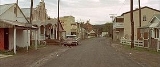
Sofala, New South Wales
Encyclopedia
Sofala is a village located approximately 250 km north-west of Sydney
, New South Wales
, within Bathurst Regional Council
. It is located beside the Turon River. Sofala is just off the Bathurst-Ilford Road
, with only local traffic through the town itself. At the 2006 census
, Sofala had a population of 208 people.
Sofala came about as a direct result of the goldrush which had been spurred on when Edward Hargraves
discovered gold at Summerhill Creek on 12 February 1851. By June of that year, thousands of people had set up mining operations in the valley and both the Royal Hotel and a General Store were built in 1851 to handle the increased demand.
Sofala has been reported to be the oldest surviving gold-rush town in Australia. There are still small-time gold prospectors who pass the time using metal detectors, gold pans, and sluice boxes to recover small quantities of gold dust.
The 1974 Peter Weir
film The Cars That Ate Paris
was filmed in the town.
Village scenes in the 1994 John Duigan
film Sirens
were also filmed in Sofala.
Sydney
Sydney is the most populous city in Australia and the state capital of New South Wales. Sydney is located on Australia's south-east coast of the Tasman Sea. As of June 2010, the greater metropolitan area had an approximate population of 4.6 million people...
, New South Wales
New South Wales
New South Wales is a state of :Australia, located in the east of the country. It is bordered by Queensland, Victoria and South Australia to the north, south and west respectively. To the east, the state is bordered by the Tasman Sea, which forms part of the Pacific Ocean. New South Wales...
, within Bathurst Regional Council
Bathurst Regional Council
Bathurst Regional Council administers the Bathurst Region Local Government Area in New South Wales, Australia. It is approximately 200 km west of Sydney and has a population of 37,001 . It is on the Great Western Highway, Mid-Western Highway, Mitchell Highway and the Main Western railway...
. It is located beside the Turon River. Sofala is just off the Bathurst-Ilford Road
Bathurst-Ilford Road
Bathurst to Ilford Road is a 72 kilometre New South Wales country road linking the Castlereagh Highway at Ilford to the regional highway hub of Bathurst, where several roads including the Great Western Highway, Mid-Western Highway and Mitchell Highways and O'Connell Road to Oberon join...
, with only local traffic through the town itself. At the 2006 census
Census in Australia
The Australian census is administered once every five years by the Australian Bureau of Statistics. The most recent census was conducted on 9 August 2011; the next will be conducted in 2016. Prior to the introduction of regular censuses in 1961, they had also been run in 1901, 1911, 1921, 1933,...
, Sofala had a population of 208 people.
Sofala came about as a direct result of the goldrush which had been spurred on when Edward Hargraves
Edward Hargraves
Edward Hammond Hargraves was a gold prospector who claimed to have found gold in Australia in 1851, starting the Australian gold rush....
discovered gold at Summerhill Creek on 12 February 1851. By June of that year, thousands of people had set up mining operations in the valley and both the Royal Hotel and a General Store were built in 1851 to handle the increased demand.
Sofala has been reported to be the oldest surviving gold-rush town in Australia. There are still small-time gold prospectors who pass the time using metal detectors, gold pans, and sluice boxes to recover small quantities of gold dust.
The 1974 Peter Weir
Peter Weir
Peter Lindsay Weir, AM is an Australian film director. After playing a leading role in the Australian New Wave cinema with his films such as Picnic at Hanging Rock, The Last Wave and Gallipoli, Weir directed a diverse group of American and international films—many of them major box office...
film The Cars That Ate Paris
The Cars that Ate Paris
The Cars That Ate Paris is a 1974 Australian horror comedy film. Directed by Peter Weir, it was his first feature film. Shot mostly in the rural town of Sofala, New South Wales, the film is set in the fictional town of Paris in which most of the inhabitants appear to be directly, or indirectly,...
was filmed in the town.
Village scenes in the 1994 John Duigan
John Duigan
John Duigan, is an Australian film director.Duigan emigrated to Australia in 1961, having been born to an Australian father...
film Sirens
Sirens (film)
Sirens is a 1993 film, written and directed by John Duigan, and set in Australia between the two World Wars.Sirens, along with Four Weddings and a Funeral and Bitter Moon—all released in the U.S...
were also filmed in Sofala.
Access
- From BathurstBathurst, New South Wales-CBD and suburbs:Bathurst's CBD is located on William, George, Howick, Russell, and Durham Streets. The CBD is approximately 25 hectares and surrounds two city blocks. Within this block layout is banking, government services, shopping centres, retail shops, a park* and monuments...
, Sofala is around 50 km north along the sealed Bathurst-Ilford RoadBathurst-Ilford RoadBathurst to Ilford Road is a 72 kilometre New South Wales country road linking the Castlereagh Highway at Ilford to the regional highway hub of Bathurst, where several roads including the Great Western Highway, Mid-Western Highway and Mitchell Highways and O'Connell Road to Oberon join...
. - From IlfordIlford, New South WalesIlford is a small town in New South Wales, Australia, in the Mid-Western Regional Council. It is named after the small English town of Ilford , where the founders of this town came from. It is situated around 220 km north west of Sydney. It is located on the Castlereagh Highway, which is...
, it is around 30 km south along the sealed Bathurst-Ilford RoadBathurst-Ilford RoadBathurst to Ilford Road is a 72 kilometre New South Wales country road linking the Castlereagh Highway at Ilford to the regional highway hub of Bathurst, where several roads including the Great Western Highway, Mid-Western Highway and Mitchell Highways and O'Connell Road to Oberon join...
. - From Hill EndHill End, New South WalesHill End is a former gold mining town in New South Wales, Australia, in Bathurst Regional Council. It owes its existence to the New South Wales gold rush of the 1850s, and at its peak in the early 1870s it had a population estimated at 8,000 served by two newspapers, five banks, eight churches, and...
, it is approximately 38 km along an unsealed road.
Attractions
- Prospecting
- Walk along the Turon River
- Cycle
- Historical Walks and Tours
- River side camp sites
See also
- Hill EndHill End, New South WalesHill End is a former gold mining town in New South Wales, Australia, in Bathurst Regional Council. It owes its existence to the New South Wales gold rush of the 1850s, and at its peak in the early 1870s it had a population estimated at 8,000 served by two newspapers, five banks, eight churches, and...
- IlfordIlford, New South WalesIlford is a small town in New South Wales, Australia, in the Mid-Western Regional Council. It is named after the small English town of Ilford , where the founders of this town came from. It is situated around 220 km north west of Sydney. It is located on the Castlereagh Highway, which is...
- CaperteeCapertee, New South WalesCapertee is a village 45km north of Lithgow, New South Wales, Australia located on an elevated site above the Capertee Valley. In 2006, the town had a population of 72 people. Situated on the Castlereagh Highway between Lithgow and Mudgee, Capertee is surrounded by National Parks and grazing land...
- BathurstBathurst, New South Wales-CBD and suburbs:Bathurst's CBD is located on William, George, Howick, Russell, and Durham Streets. The CBD is approximately 25 hectares and surrounds two city blocks. Within this block layout is banking, government services, shopping centres, retail shops, a park* and monuments...
- Australian gold rushesAustralian gold rushesThe Australian gold rush started in 1851 when prospector Edward Hammond Hargraves claimed the discovery of payable gold near Bathurst, New South Wales, at a site Edward Hargraves called Ophir.Eight months later, gold was found in Victoria...
- Gold miningGold miningGold mining is the removal of gold from the ground. There are several techniques and processes by which gold may be extracted from the earth.-History:...