

Skinny House
Encyclopedia
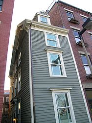
The Skinny House at 44 Hull Street in the North End
of Boston, Massachusetts, USA
, is an extremely narrow four-story house reported by the Boston Globe as having the "uncontested distinction of being the narrowest house in Boston." According to the executive director
of the Boston Landmarks Commission, "In a city where there are many narrow lots, this far exceeds the norm...As far as we know, it is the narrowest house in Boston." It was originally built as a spite house
.
There are only five doors in the house although it has four levels. The second floor holds the living room and the bathroom, one of few spaces separated by a door. As of 2005, the owners are Jennifer Simonic and Spencer Welton, who live what the Boston Globe called "a vertical life".
Simonic described:
According to Welton, who has a degree in architecture, "Instead of doors, we have floors between each space...When guests stay over, we put a mattress down on the closet floor...Except for sleeping in the closet, they seem to like it."
 The structure was built as a "spite house
" shortly after the American Civil War
. According to local legend:
Another source says:
According to an assistant archivist at the Boston City Archives, the footprint of 44 Hull Street appeared in The Hopkins Atlas of 1874, Boston Proper
. The land was split into five lots in 1884. The smallest of these lots measured only 274 square feet (25.5 m²). This corresponds to the size of the house before renovations that lengthened it.
, across the street from the historic Copp's Hill Burying Ground and within sight of Old North Church
, both official stops on Boston's historic Freedom Trail
.
North End, Boston, Massachusetts
The North End is a neighborhood of Boston, Massachusetts. It has the distinction of being the city's oldest residential community, where people have lived continuously since it was settled in the 1630s. Though small , the neighborhood has approximately 100 eating establishments, and a variety of...
of Boston, Massachusetts, USA
United States
The United States of America is a federal constitutional republic comprising fifty states and a federal district...
, is an extremely narrow four-story house reported by the Boston Globe as having the "uncontested distinction of being the narrowest house in Boston." According to the executive director
Executive director
Executive director is a term sometimes applied to the chief executive officer or managing director of an organization, company, or corporation. It is widely used in North American non-profit organizations, though in recent decades many U.S. nonprofits have adopted the title "President/CEO"...
of the Boston Landmarks Commission, "In a city where there are many narrow lots, this far exceeds the norm...As far as we know, it is the narrowest house in Boston." It was originally built as a spite house
Spite house
A spite house is a building constructed or modified to irritate neighbors or other parties with land stakes. Spite houses often serve as obstructions, blocking out light or access to neighboring buildings, or as flamboyant symbols of defiance...
.
Description
The house spans 10.4 feet (3.16 m) at Hull Street, its widest point. There is no entrance here; the house may only be entered via a small alley. The house tapers to 9.25 feet (2.82 m) at the back. Interior walls are as little as 8.4 feet (2.56 m) wide and none are more than 9.2 feet (2.80 m) wide. The home's narrowest interior point is 6.2 feet (1.89 m) across, close enough to allow an adult to touch opposing walls.There are only five doors in the house although it has four levels. The second floor holds the living room and the bathroom, one of few spaces separated by a door. As of 2005, the owners are Jennifer Simonic and Spencer Welton, who live what the Boston Globe called "a vertical life".
Simonic described:
We had a party of 10 one New Year's Eve, and when one person has to go to the bathroom, everyone has to move...We've had people just walk into our backyard and sit at our picnic table...They say, "We'll just be a couple of minutes, we just want to take a couple of pictures." That was bizarre.
According to Welton, who has a degree in architecture, "Instead of doors, we have floors between each space...When guests stay over, we put a mattress down on the closet floor...Except for sleeping in the closet, they seem to like it."
History
Spite house
A spite house is a building constructed or modified to irritate neighbors or other parties with land stakes. Spite houses often serve as obstructions, blocking out light or access to neighboring buildings, or as flamboyant symbols of defiance...
" shortly after the American Civil War
American Civil War
The American Civil War was a civil war fought in the United States of America. In response to the election of Abraham Lincoln as President of the United States, 11 southern slave states declared their secession from the United States and formed the Confederate States of America ; the other 25...
. According to local legend:
...two brothers inherited land from their deceased father. While one brother was away serving in the militaryUnion ArmyThe Union Army was the land force that fought for the Union during the American Civil War. It was also known as the Federal Army, the U.S. Army, the Northern Army and the National Army...
, the other built a large home, leaving the soldierSoldierA soldier is a member of the land component of national armed forces; whereas a soldier hired for service in a foreign army would be termed a mercenary...
only a shred of propertyReal estateIn general use, esp. North American, 'real estate' is taken to mean "Property consisting of land and the buildings on it, along with its natural resources such as crops, minerals, or water; immovable property of this nature; an interest vested in this; an item of real property; buildings or...
that he felt certain was too tiny to build on. When the soldier returned, he found his inheritance depleted and built the narrow house to spite his brother by blocking the sunlight and ruining his view...
Another source says:
Not much is known about the city's narrowest house. Legend has it that...its unnamed builder erected it to shut off air and light from the home of a hostile neighbor (also nameless) with whom he had a dispute....Believed to have been built after 1874
According to an assistant archivist at the Boston City Archives, the footprint of 44 Hull Street appeared in The Hopkins Atlas of 1874, Boston Proper
Atlas
An atlas is a collection of maps; it is typically a map of Earth or a region of Earth, but there are atlases of the other planets in the Solar System. Atlases have traditionally been bound into book form, but today many atlases are in multimedia formats...
. The land was split into five lots in 1884. The smallest of these lots measured only 274 square feet (25.5 m²). This corresponds to the size of the house before renovations that lengthened it.
Location
The house stands near the top of Copp's HillCopp's Hill
Copp's Hill is an elevation in the historic North End of Boston, Massachusetts. It is bordered by Hull Street, Charter Street and Snow Hill Street. The hill takes its name from William Copp, a shoemaker who once owned the land...
, across the street from the historic Copp's Hill Burying Ground and within sight of Old North Church
Old North Church
Old North Church , at 193 Salem Street, in the North End of Boston, is the location from which the famous "One if by land, and two if by sea" signal is said to have been sent...
, both official stops on Boston's historic Freedom Trail
Freedom Trail
The Freedom Trail is a red path through downtown Boston, Massachusetts, that leads to 16 significant historic sites. It is a 2.5-mile walk from Boston Common to Bunker Hill Monument in Charlestown. Simple ground markers explaining events, graveyards, notable churches and other buildings, and a...
.