
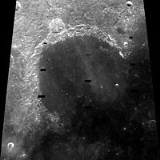
Sinus Iridum
Encyclopedia
Basalt
Basalt is a common extrusive volcanic rock. It is usually grey to black and fine-grained due to rapid cooling of lava at the surface of a planet. It may be porphyritic containing larger crystals in a fine matrix, or vesicular, or frothy scoria. Unweathered basalt is black or grey...
lava
Lava
Lava refers both to molten rock expelled by a volcano during an eruption and the resulting rock after solidification and cooling. This molten rock is formed in the interior of some planets, including Earth, and some of their satellites. When first erupted from a volcanic vent, lava is a liquid at...
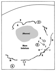
that forms a northwestern extension to the Mare Imbrium
Mare Imbrium
Mare Imbrium, Latin for "Sea of Showers" or "Sea of Rains", is a vast lunar mare filling a basin on Earth's Moon and one of the larger craters in the Solar System. Mare Imbrium was created when lava flooded the giant crater formed when a very large object hit the Moon long ago...
. It is surrounded from the northeast to the southwest by the Montes Jura
Montes Jura
Montes Jura is a mountain range in the northwest part of the Moon . The selenographic coordinates of this range are 47.1° N 34.0° W, and it has a diameter of 422 km...
range. The protruding part of the range at the southwest end is named Promontorium Heraclides
Promontorium Heraclides
Promontorium Heraclides is a raised mountainous cape situated in Mare Imbrium on the near side of the Moon. Its selenographic coordinates are 40.3° N, 33.2° W and it is 50 km in diameter. It marks the western edge of the bay of Sinus Iridum....
, while that at the northeast end is called Promontorium Laplace
Promontorium Laplace
Promontorium Laplace is a raised mountainous cape situated at the end of Montes Jura in Mare Imbrium on the near side of the Moon. Its selenographic coordinates are 46.0° N, 26.0° W and it is 2600 meters high. It is the east beginning of the bay of Sinus Iridum....
. This bay and the surrounding mountains is considered one of the most beautiful features on the Moon, and is a favorite among lunar observers.
Sinus Iridum does not contain any notable impact craters, but does include the satellite crater Heraclides E in the south, Laplace A along the eastern edge, and Bianchini G in the north. The surface is level, but is marked by a number of wrinkle ridges.
The selenographic coordinates
Selenographic coordinates
Selenographic coordinates are used to refer to locations on the surface of Earth's moon. Any position on the lunar surface can be referenced by specifying two numerical values, which are comparable to the latitude and longitude of Earth...
of this bay are 44.1° N, 31.5° W, and the diameter is 236 km. The feature was given the latin
Latin
Latin is an Italic language originally spoken in Latium and Ancient Rome. It, along with most European languages, is a descendant of the ancient Proto-Indo-European language. Although it is considered a dead language, a number of scholars and members of the Christian clergy speak it fluently, and...
name for the Bay of Rainbows by Giovanni Riccioli
Giovanni Battista Riccioli
Giovanni Battista Riccioli was an Italian astronomer and a Catholic priest in the Jesuit order...
.
Satellite craters
By convention these features are identified on lunar maps by placing the letter on the side of the crater mid-point that is closest to Promontorium Heraclides.| Heraclides | Latitude | Longitude | Diameter |
|---|---|---|---|
| A | 40.9° N | 34.2° W | 6 km |
| E | 42.9° N | 32.7° W | 4 km |
| F | 38.5° N | 33.7° W | 3 km |
The following satellite craters are associated with the Promontorium Laplace.
| Laplace | Latitude | Longitude | Diameter |
|---|---|---|---|
| A | 43.7° N | 26.8° W | 9 km |
| B | 51.3° N | 19.8° W | 5 km |
| D | 47.3° N | 25.5° W | 11 km |
| E | 50.3° N | 19.8° W | 6 km |
| F | 45.6° N | 19.8° W | 6 km |
| L | 51.7° N | 21.0° W | 7 km |
| M | 52.2° N | 19.9° W | 6 km |