
Sinks of Gandy
Encyclopedia
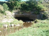
The Sinks of Gandy, also called the Sinks of Gandy Creek, or simply “The Sinks” are a modestly celebrated cave
and underground stream at Osceola
in eastern Randolph County, West Virginia
, USA. The Sinks are on private property within the Potomac Ranger District of the Monongahela National Forest
.
, for about 3,000 feet (915 meters) as it passes under a spur
of Yokum Knob to reemerge on the opposite side of Randolph County Route 40 (Dry Fork Road). The southern (upstream) entrance to the Sinks, about 30 feet (9.1 m) wide and 15 feet (4.6 m) high, is in a low ledge of limestone in a large depressed meadow. It consists of a simple longitudinal passage, from 4 to 35 feet (10.7 m) high, with a few minor side passages, not much apparent from the main passage. The main cave passage averages 40 to 60 feet (18.3 m) wide, but in some places up to 100 feet (30.5 m) wide. In some sections the stream occupies the entire floor of the passage, but in other sections it is confined to a narrow trench. The northern (downstream) entrance is offset about 100 feet (30.5 m) to the east of the stream channel, which exits under some boulders, making a second (wet) avenue of egress.
 Local settlers were certainly well aware of the Sinks by the 1830s. The earliest recorded reference to the Sinks may be a November 1833 letter sent by Randolph County physician Benjamin Dolbeare to the Virginia Historical and Philosophical Society
in Richmond. Dolbeare described several local caves including one as follows (with original spellings).
"Between, what is here called, the Aleghany and Rich Mountains, heads a branch of the dry fork a tributary of Cheat River, a ridge extends itself quiet across, from one mountain to the other, and this branc[h], after keeping its course about 3 miles runs under this ridge which [is] about ¾ of mile wide at its base, and very high."
The Sinks were noted locally as the site of the last known killings of elk
by hunters in what is now Randolph County, probably about 1830 and 1835. (The last elk killed in all of West Virginia were shot around 1843 in nearby Canaan Valley.)
In March 1864, a minor incident of the Civil War occurred at the Sinks. Eight men of General Imboden
’s Confederate command, who had been waylaying wagon trains in the north, crossed into neighboring Tucker County
where they robbed a general store about 3 miles from the town of Saint George. They were pursued by a Union captain and lieutenant who closed on them the next day at the Sinks. Three rebels were killed in the ensuing shootout, two captured and the stolen property recovered.
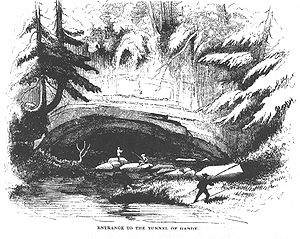
The Sinks first came to widespread public notice by way of a tongue-in-cheek account of a pleasure expedition to the region published by David Hunter Strother
in Harper’s Magazine in 1872 and 1873, although the visit upon which it is based probably occurred around 1854. This story, entitled "The Mountains", details the high jinx of a group of lively “Virginia gentlemen” who bumble through the then-virgin forest, annoying the sullen local “mountaineers”, in search of the “tunnel of Gandy”. This semi-fictionalized narrative treated the locals in rather xenophobic terms and recounted a lurid tale of cattle rustling, abduction and desperate escape in the cave and the surrounding area.
The Sinks again became the object of a popularization effort when West Virginia writer Jack Preble published a series of articles and booklets about them between the 1940s and the 1960s. Preble’s anecdotal and romanticizing approach was little more reliable than Strother’s at giving an accurate account of the cave. It was also during this period that the West Virginia Highway Department began, with an eye toward the tourist potential, to replace the designation of “Osceola” with that of “The Sinks” on its official roadmaps.
The Sinks were first formally surveyed and mapped by members of the National Speleological Society
on 1 September 1940 resulting in a figure of 3056 feet (931.5 m) of passage . The cave was resurveyed in 1990 resulting in 5,058 additional feet for a total of 8114 feet (2,473.1 m) of passage. This makes the Sinks the 642nd longest surveyed cave in the U.S. as of 19 September 2010
The cave is relatively forgiving to inexperienced visitors. Because of its straightforward layout, most visitors can traverse it without getting lost. A combination of scrambling and wading are required to pass some stretches, however, and many a visitor cannot locate the dry, downstream entrance (about 200 feet (61 m) back and to the right from the wet stream exit) and is therefore compelled to return the way he came.
Cave
A cave or cavern is a natural underground space large enough for a human to enter. The term applies to natural cavities some part of which is in total darkness. The word cave also includes smaller spaces like rock shelters, sea caves, and grottos.Speleology is the science of exploration and study...
and underground stream at Osceola
Osceola, West Virginia
Osceola is a former logging community in eastern Randolph County, West Virginia, USA. It was located within what is now the Monongahela National Forest on Gandy Creek at the southern extremity of Little Middle Mountain and Yokum Knob....
in eastern Randolph County, West Virginia
Randolph County, West Virginia
As of the census of 2000, there were 28,262 people, 11,072 households, and 7,661 families residing in the county. The population density was 27 people per square mile . There were 13,478 housing units at an average density of 13 per square mile...
, USA. The Sinks are on private property within the Potomac Ranger District of the Monongahela National Forest
Monongahela National Forest
The Monongahela National Forest is a national forest located in the Allegheny Mountains of eastern West Virginia, USA. It protects over of federally-owned land within a proclamation boundary that includes much of the Potomac Highlands Region and portions of 10 counties.The MNF includes some...
.
Description
The Sinks are a natural tunnel accommodating Gandy Creek, a tributary of Dry ForkDry Fork (Cheat River)
The Dry Fork is a tributary of the Black Fork of the Cheat River in the Allegheny Mountains of eastern West Virginia in the United States. Via the Black Fork, the Cheat, and the Monongahela and Ohio rivers, it is part of the watershed of the Mississippi River. The Dry Fork flows for much of its...
, for about 3,000 feet (915 meters) as it passes under a spur
Spur (mountain)
A spur is a subsidiary summit of a hill or mountain. By definition, spurs have low topographic prominence, as they are lower than their parent summit and are closely connected to them on the same ridgeline...
of Yokum Knob to reemerge on the opposite side of Randolph County Route 40 (Dry Fork Road). The southern (upstream) entrance to the Sinks, about 30 feet (9.1 m) wide and 15 feet (4.6 m) high, is in a low ledge of limestone in a large depressed meadow. It consists of a simple longitudinal passage, from 4 to 35 feet (10.7 m) high, with a few minor side passages, not much apparent from the main passage. The main cave passage averages 40 to 60 feet (18.3 m) wide, but in some places up to 100 feet (30.5 m) wide. In some sections the stream occupies the entire floor of the passage, but in other sections it is confined to a narrow trench. The northern (downstream) entrance is offset about 100 feet (30.5 m) to the east of the stream channel, which exits under some boulders, making a second (wet) avenue of egress.
History
Virginia Historical Society
The Virginia Historical Society , founded in 1831 as the Virginia Historical and Philosophical Society and headquartered in Richmond, Virginia, is a major repository, research, and teaching center for Virginia history...
in Richmond. Dolbeare described several local caves including one as follows (with original spellings).
"Between, what is here called, the Aleghany and Rich Mountains, heads a branch of the dry fork a tributary of Cheat River, a ridge extends itself quiet across, from one mountain to the other, and this branc[h], after keeping its course about 3 miles runs under this ridge which [is] about ¾ of mile wide at its base, and very high."
The Sinks were noted locally as the site of the last known killings of elk
Elk
The Elk is the large deer, also called Cervus canadensis or wapiti, of North America and eastern Asia.Elk may also refer to:Other antlered mammals:...
by hunters in what is now Randolph County, probably about 1830 and 1835. (The last elk killed in all of West Virginia were shot around 1843 in nearby Canaan Valley.)
In March 1864, a minor incident of the Civil War occurred at the Sinks. Eight men of General Imboden
John D. Imboden
John Daniel Imboden was a lawyer, teacher, Virginia state legislator. During the American Civil War, he was a Confederate cavalry general and partisan fighter...
’s Confederate command, who had been waylaying wagon trains in the north, crossed into neighboring Tucker County
Tucker County, West Virginia
As of the census of 2000, there were 7,321 people, 3,052 households, and 2,121 families residing in the county. The population density was 18 people per square mile . There were 4,634 housing units at an average density of 11 per square mile...
where they robbed a general store about 3 miles from the town of Saint George. They were pursued by a Union captain and lieutenant who closed on them the next day at the Sinks. Three rebels were killed in the ensuing shootout, two captured and the stolen property recovered.
The Sinks first came to widespread public notice by way of a tongue-in-cheek account of a pleasure expedition to the region published by David Hunter Strother
David Hunter Strother
David Hunter Strother was a successful 19th century American magazine illustrator and writer, popularly known by his pseudonym, "Porte Crayon" .-Early life:...
in Harper’s Magazine in 1872 and 1873, although the visit upon which it is based probably occurred around 1854. This story, entitled "The Mountains", details the high jinx of a group of lively “Virginia gentlemen” who bumble through the then-virgin forest, annoying the sullen local “mountaineers”, in search of the “tunnel of Gandy”. This semi-fictionalized narrative treated the locals in rather xenophobic terms and recounted a lurid tale of cattle rustling, abduction and desperate escape in the cave and the surrounding area.
The Sinks again became the object of a popularization effort when West Virginia writer Jack Preble published a series of articles and booklets about them between the 1940s and the 1960s. Preble’s anecdotal and romanticizing approach was little more reliable than Strother’s at giving an accurate account of the cave. It was also during this period that the West Virginia Highway Department began, with an eye toward the tourist potential, to replace the designation of “Osceola” with that of “The Sinks” on its official roadmaps.
The Sinks were first formally surveyed and mapped by members of the National Speleological Society
National Speleological Society
The National Speleological Society is an organization formed in 1941 to advance the exploration, conservation, study, and understanding of caves in the United States. Originally located in Washington D.C., its current offices are in Huntsville, Alabama...
on 1 September 1940 resulting in a figure of 3056 feet (931.5 m) of passage . The cave was resurveyed in 1990 resulting in 5,058 additional feet for a total of 8114 feet (2,473.1 m) of passage. This makes the Sinks the 642nd longest surveyed cave in the U.S. as of 19 September 2010
Amateur appeal
Both entrances to the Sinks are located on private land. The upstream entrance is owned by the Teter family and the downstream exit is owned by the Tingler family. The location of the cave is not identified by any signage in the area.The cave is relatively forgiving to inexperienced visitors. Because of its straightforward layout, most visitors can traverse it without getting lost. A combination of scrambling and wading are required to pass some stretches, however, and many a visitor cannot locate the dry, downstream entrance (about 200 feet (61 m) back and to the right from the wet stream exit) and is therefore compelled to return the way he came.
Other sources
- McGrew, Wes, Netherworld News, September 1959.
- Perry, Clay, “Come Let’s Go Spelunking”, Saturday Evening Post, pp. 14-15, 36, 38; 12 July 1941.
- Sanford, Dick, The Potomac Caver, March 1969.