

Silverado Canyon (Orange County)
Encyclopedia
Silverado Canyon is a roughly 2500 feet (762 m)-deep gorge in the Santa Ana Mountains
, in the U.S. state
of California
. The small stream it is associated with, Silverado Creek, rises on the north slope of Modjeska Peak
at the elevation of 3980 feet (1,213.1 m) and flows north and west, past the town of Silverado
to join Santiago Creek
at 942 feet (287.1 m) after a journey of just under 5 miles (8 km). The main branch, Ladd Canyon, is just over 3 miles (4.8 km) long. Its stream arises on the east flank of Pleasants Peak at about 3590 feet (1,094.2 m) and flows southwest into the main stem at about 1178 feet (359.1 m) near Silverado. They are part of the Santa Ana River
watershed
. A hiking trail/fire road runs the entire length of the canyon.
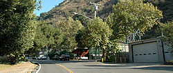 The town of Silverado
is situated in the canyon, with most of its buildings between the point where the canyon opens out into a valley and a U.S. Forest Service gate where the valley road enters the Cleveland National Forest
. The town is mostly residential; there are, however, also a few stores, mostly in the east side. 5498 feet (1,675.8 m) Modjeska Peak
, part of Saddleback, rises to the south; 3947 feet (1,203 m) Bald Peak forms the head of the gorge to the east, and 3800 feet (1,158.2 m) Bedford Peak towers to the north.
Silverado Creek runs year round, reaching its highest flow in winter and early Spring, while diminishing to a trickle most of the rest of the year. For its first few miles through the upper reaches of the gorge, its flow is perennial, although it has been known to dry up at the low-water crossing directly upstream of the Forest Service gate. By the time it reaches the downstream end of Silverado, it is usually dry. Most of its tributaries, including Ladd Canyon Creek, are also seasonal.
Several trails run out of the canyon. One of the most popular is the Silverado Motorway, which was originally a fire road but now is overgrown with plants, forming a single-track trail. The trail climbs out of the canyon towards the northeast and eventually intersects the Main Divide Road, which runs along the canyon rim to the north and east.
The canyon is so named because silver mines originally operated in the area. Tailings from the Blue Light Mine milling operation on the south side of the canyon still leak toxic waste into the creek and surrounding soil, and cleanup is underway by the Forest Service. In 2002, two people exploring the mine drowned in one of the flooded lower passageways.
Santa Ana Mountains
The Santa Ana Mountains are a short peninsular mountain range along the coast of Southern California in the United States. They extend for approximately 36 mi southeast of the Los Angeles Basin largely along the border between Orange and Riverside counties.- Geography :The range starts in the...
, in the U.S. state
U.S. state
A U.S. state is any one of the 50 federated states of the United States of America that share sovereignty with the federal government. Because of this shared sovereignty, an American is a citizen both of the federal entity and of his or her state of domicile. Four states use the official title of...
of California
California
California is a state located on the West Coast of the United States. It is by far the most populous U.S. state, and the third-largest by land area...
. The small stream it is associated with, Silverado Creek, rises on the north slope of Modjeska Peak
Modjeska Peak
Modjeska Peak is the northern mountain of Orange County's Saddleback formation. It is the second highest peak of the Santa Ana Mountains.The peak is named for Shakespearean actress Helena Modjeska, who lived in its shadow near the end of her life....
at the elevation of 3980 feet (1,213.1 m) and flows north and west, past the town of Silverado
Silverado, California
Founded in 1878, Silverado , a California Historical Landmark, is an unincorporated community in Silverado Canyon, which is located in the Santa Ana Mountains in eastern Orange County, California. Portions of the town sit on a former Mexican land grant Rancho Lomas de Santiago. The majority of...
to join Santiago Creek
Santiago Creek
Santiago Creek is a major watercourse in Orange County in the U.S. state of California. About long, it drains most of the northern Santa Ana Mountains and is a tributary to the Santa Ana River...
at 942 feet (287.1 m) after a journey of just under 5 miles (8 km). The main branch, Ladd Canyon, is just over 3 miles (4.8 km) long. Its stream arises on the east flank of Pleasants Peak at about 3590 feet (1,094.2 m) and flows southwest into the main stem at about 1178 feet (359.1 m) near Silverado. They are part of the Santa Ana River
Santa Ana River
The Santa Ana River is the largest river of Southern California in the United States. Its drainage basin spans four counties. It rises in the San Bernardino Mountains and flows past the cities of San Bernardino and Riverside, before cutting through the northern tip of the Santa Ana Mountains and...
watershed
Drainage basin
A drainage basin is an extent or an area of land where surface water from rain and melting snow or ice converges to a single point, usually the exit of the basin, where the waters join another waterbody, such as a river, lake, reservoir, estuary, wetland, sea, or ocean...
. A hiking trail/fire road runs the entire length of the canyon.
Silverado, California
Founded in 1878, Silverado , a California Historical Landmark, is an unincorporated community in Silverado Canyon, which is located in the Santa Ana Mountains in eastern Orange County, California. Portions of the town sit on a former Mexican land grant Rancho Lomas de Santiago. The majority of...
is situated in the canyon, with most of its buildings between the point where the canyon opens out into a valley and a U.S. Forest Service gate where the valley road enters the Cleveland National Forest
Cleveland National Forest
Cleveland National Forest encompasses 460,000 acres , mostly of chaparral, with a few riparian areas. A warm dry mediterranean climate prevails over the Forest. It is the southernmost National forest of California. It is administered by the United States Forest Service, a government agency within...
. The town is mostly residential; there are, however, also a few stores, mostly in the east side. 5498 feet (1,675.8 m) Modjeska Peak
Modjeska Peak
Modjeska Peak is the northern mountain of Orange County's Saddleback formation. It is the second highest peak of the Santa Ana Mountains.The peak is named for Shakespearean actress Helena Modjeska, who lived in its shadow near the end of her life....
, part of Saddleback, rises to the south; 3947 feet (1,203 m) Bald Peak forms the head of the gorge to the east, and 3800 feet (1,158.2 m) Bedford Peak towers to the north.
Silverado Creek runs year round, reaching its highest flow in winter and early Spring, while diminishing to a trickle most of the rest of the year. For its first few miles through the upper reaches of the gorge, its flow is perennial, although it has been known to dry up at the low-water crossing directly upstream of the Forest Service gate. By the time it reaches the downstream end of Silverado, it is usually dry. Most of its tributaries, including Ladd Canyon Creek, are also seasonal.
Several trails run out of the canyon. One of the most popular is the Silverado Motorway, which was originally a fire road but now is overgrown with plants, forming a single-track trail. The trail climbs out of the canyon towards the northeast and eventually intersects the Main Divide Road, which runs along the canyon rim to the north and east.
The canyon is so named because silver mines originally operated in the area. Tailings from the Blue Light Mine milling operation on the south side of the canyon still leak toxic waste into the creek and surrounding soil, and cleanup is underway by the Forest Service. In 2002, two people exploring the mine drowned in one of the flooded lower passageways.