

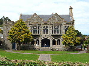
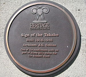
Sign of the Takahe
Encyclopedia
Manor house
A manor house is a country house that historically formed the administrative centre of a manor, the lowest unit of territorial organisation in the feudal system in Europe. The term is applied to country houses that belonged to the gentry and other grand stately homes...
. Designed by J. G. Collins
Armson, Collins and Harman
Armson, Collins and Harman was an architectural firm in New Zealand. It was founded by William Barnett Armson , and after his death, became the practice of two of architects who articled with him, John James Collins and Richard Dacre Harman .-History:Armson, Collins and Harman was one of the two...
, construction was carried out between 1918 and 1948. The Takahe also provides one of the better panoramic views of the city of Christchurch
Christchurch
Christchurch is the largest city in the South Island of New Zealand, and the country's second-largest urban area after Auckland. It lies one third of the way down the South Island's east coast, just north of Banks Peninsula which itself, since 2006, lies within the formal limits of...
, New Zealand
New Zealand
New Zealand is an island country in the south-western Pacific Ocean comprising two main landmasses and numerous smaller islands. The country is situated some east of Australia across the Tasman Sea, and roughly south of the Pacific island nations of New Caledonia, Fiji, and Tonga...
, the Canterbury Plains
Canterbury Plains
The Canterbury Plains are an area in New Zealand centred to the south of the city of Christchurch in the Canterbury Region. Their northern extremes are at the foot of the Hundalee Hills in the Hurunui District, and in the south they merge into the plains of North Otago beyond the Waitaki...
and the Southern Alps
Southern Alps
The Southern Alps is a mountain range extending along much of the length of New Zealand's South Island, reaching its greatest elevations near the island's western side...
.
Named after the flightless native New Zealand bird, the Takahe
Takahe
The Takahē or South Island Takahē, Porphyrio hochstetteri is a flightless bird indigenous to New Zealand and belonging to the rail family. It was thought to be extinct after the last four known specimens were taken in 1898...
, it was initially one of the roadhouses planned by Henry George (Harry) Ell
Henry Ell
Henry George Ell , commonly known as Harry Ell, was a Christchurch City councillor and a New Zealand Member of Parliament...
as part of his scheme to preserve the natural state of the Port Hills
Port Hills
The Port Hills form the northern rim of the ancient Lyttelton volcano, separating the port of Lyttelton from the city of Christchurch in Canterbury, New Zealand...
which overlook Christchurch and Lyttelton
Lyttelton, New Zealand
Lyttelton is a port town on the north shore of Lyttelton Harbour close to Banks Peninsula, a suburb of Christchurch on the eastern coast of the South Island of New Zealand....
harbour.
Ell had envisaged four roadhouses being built, and three were completed before Ell's death in 1934. These were Sign of the Kiwi
Sign of the Kiwi
The Sign of the Kiwi, originally called Toll House, is a small café and shop at Dyers Pass on the road between Christchurch and Governors Bay. It was built in 1916/1917 by Harry Ell as a staging post and opened as a tearoom and rest house...
, Sign of the Bellbird and Sign of the Packhorse.
However, Ell wished the Takahe to be a more substantial structure and spent years studying design of English Manors, castles and inns, to be incorporated into the final construction of the Takahe. Indeed, the dining room is an exact replica in the historic Haddon Hall
Haddon Hall
Haddon Hall is an English country house on the River Wye at Bakewell, Derbyshire, one of the seats of the Duke of Rutland, occupied by Lord Edward Manners and his family. In form a medieval manor house, it has been described as "the most complete and most interesting house of [its]...
in Derbyshire
Derbyshire
Derbyshire is a county in the East Midlands of England. A substantial portion of the Peak District National Park lies within Derbyshire. The northern part of Derbyshire overlaps with the Pennines, a famous chain of hills and mountains. The county contains within its boundary of approx...
.
A great deal of improvisation was required to minimize cost. For example the stone was quarried locally from the Port Hills and hand chiseled into blocks using primitive tools, the heavy Kauri beams in the entrance hall were salvaged from a former bridge over the Hurunui River
Hurunui River
The Hurunui River is the fourth largest of the four principal rivers in north Canterbury, New Zealand, with a catchment area of 2,670 square kilometres. The river flows from the eastern side of the Southern Alps, to the Pacific Ocean....
and the ceilings in the inner most dining room were painted on timber cut from packing cases.
The building has a Category I listing with the New Zealand Historic Places Trust.