
Shire of Williams
Encyclopedia
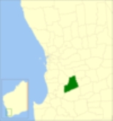
The Shire of Williams is a Local Government Area
in the Wheatbelt region of Western Australia
, about 161 kilometres (100 mi) southeast of the state capital, Perth
. The Shire covers an area of 2306 square kilometres (890 sq mi), and its seat of government is the town of Williams
.
Local Government Areas of Western Australia
The Australian state of Western Australia is divided into 141 local government areas...
in the Wheatbelt region of Western Australia
Western Australia
Western Australia is a state of Australia, occupying the entire western third of the Australian continent. It is bounded by the Indian Ocean to the north and west, the Great Australian Bight and Indian Ocean to the south, the Northern Territory to the north-east and South Australia to the south-east...
, about 161 kilometres (100 mi) southeast of the state capital, Perth
Perth, Western Australia
Perth is the capital and largest city of the Australian state of Western Australia and the fourth most populous city in Australia. The Perth metropolitan area has an estimated population of almost 1,700,000....
. The Shire covers an area of 2306 square kilometres (890 sq mi), and its seat of government is the town of Williams
Williams, Western Australia
Williams is a town located in the Wheatbelt region of Western Australia, south-southeast of the state capital, Perth along Albany Highway and 32 kilometres west of Narrogin. The Williams River passes through the town. At the 2006 census, Williams had a population of 338.-History:Williams is...
.
History
The Williams Road District was created in 1871 as one of the first regional local government areas in Western Australia. On 1 July 1961, it became a Shire following the enactment of the Local Government Act 1960.Wards
Until 2002, the shire was divided into 3 wards - North West (1), North East (1) and Central (3). On 3 May 2003 all wards were abolished and councillors sit at large.Towns and localities
- WilliamsWilliams, Western AustraliaWilliams is a town located in the Wheatbelt region of Western Australia, south-southeast of the state capital, Perth along Albany Highway and 32 kilometres west of Narrogin. The Williams River passes through the town. At the 2006 census, Williams had a population of 338.-History:Williams is...
- Boraning
- CongelinCongelin, Western AustraliaCongelin is a locality in the Wheatbelt region of Western Australia, north of Williams. It is located within the Shire of Williams.-History:...
- Culbin
- Narrakine
- QuindanningQuindanning, Western AustraliaQuindanning is a small town located halfway between Boddington and Williams along the Pinjarra-Williams Road. At the 2006 census, Quindanning had a population of 163....
Population
| Year | Population |
|---|---|
| 1911 | 866 |
| 1921 | 772 |
| 1933 | 929 |
| 1947 | 933 |
| 1954 | 1,413 |
| 1961 | 1,330 |
| 1966 | 1,193 |
| 1971 | 1,177 |
| 1976 | 1,178 |
| 1981 | 1,174 |
| 1986 | 1,146 |
| 1991 | 1,005 |
| 1996 | 1,018 |
| 2001 | 869 |
| 2006 | 863 |