
Shire of Waroona
Encyclopedia
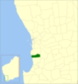
The Shire of Waroona is a Local Government Area
in the Peel region of Western Australia
between Mandurah
and Harvey
and about 110 kilometres (68 mi) south of Perth
, the state capital. The Shire covers an area of about 835 km² (322 mi²) and its seat of government is the town of Waroona
.
National parks and state forests based around both the Yalgorup lakes and the Darling Scarp jarrah forests occupy approximately half the land area of the Shire.
Local Government Areas of Western Australia
The Australian state of Western Australia is divided into 141 local government areas...
in the Peel region of Western Australia
Western Australia
Western Australia is a state of Australia, occupying the entire western third of the Australian continent. It is bounded by the Indian Ocean to the north and west, the Great Australian Bight and Indian Ocean to the south, the Northern Territory to the north-east and South Australia to the south-east...
between Mandurah
Mandurah, Western Australia
Mandurah is the second-largest city in Western Australia and is located approximately south of the state capital, Perth.The city attracts a large number of tourists, including many international visitors...
and Harvey
Harvey, Western Australia
Harvey is a town located in the South West of Western Australia along the South Western Highway, 140 km south of Perth, between Pinjarra and Bunbury...
and about 110 kilometres (68 mi) south of Perth
Perth, Western Australia
Perth is the capital and largest city of the Australian state of Western Australia and the fourth most populous city in Australia. The Perth metropolitan area has an estimated population of almost 1,700,000....
, the state capital. The Shire covers an area of about 835 km² (322 mi²) and its seat of government is the town of Waroona
Waroona, Western Australia
Waroona is a town located in the Peel region of Western Australia along the South Western Highway, between Pinjarra and Harvey. The town is the seat of the Shire of Waroona. At the 2006 census, Waroona had a population of 1,864.-History:...
.
History
The district was originally controlled by the Murray Road Board (from 1887). In 1898, the Drakesbrook Road Board was gazetted. Years after the renaming of the town, on 19 May 1961, the Drakesbrook Road Board was abolished. It was to become the Waroona Road Board, but due to changes in the Local Government Act approved earlier in the year, it became the Waroona Shire Council on 1 July 1961 in line with many other councils.Wards
The shire no longer has wards, it is made up of 8 Councillors that represent the whole of the ShireTowns
The Shire of Waroona contains the following towns and localities:- HamelHamel, Western AustraliaHamel is a town located in the Peel region of Western Australia just off the South Western Highway, between Waroona and Harvey. At the 2006 census, Hamel had a population of 347.-History:...
- Lake CliftonLake Clifton, Western AustraliaLake Clifton is a small town located on the east side of the lake of the same name in the Peel region of Western Australia just off the Old Coast Road, between Mandurah and Bunbury at the north end of the Yalgorup National Park...
- Nanga BrookNanga Brook, Western AustraliaNanga Brook is a former town located in the Peel region of Western Australia in the Lane-Poole Reserve between Dwellingup and Waroona.-History:The area was home to a milling town that operated from about 1900 until the Dwellingup fires of 1961...
- Preston BeachPreston Beach, Western AustraliaPreston Beach is a small town located in the Peel region of Western Australia just off the Old Coast Road, between Mandurah and Bunbury in the Yalgorup National Park.-History:...
- WagerupWagerup, Western AustraliaWagerup is a town located in the Peel region of Western Australia just off the South Western Highway, between Waroona and Harvey.-History:...
- WaroonaWaroona, Western AustraliaWaroona is a town located in the Peel region of Western Australia along the South Western Highway, between Pinjarra and Harvey. The town is the seat of the Shire of Waroona. At the 2006 census, Waroona had a population of 1,864.-History:...
National parks and state forests based around both the Yalgorup lakes and the Darling Scarp jarrah forests occupy approximately half the land area of the Shire.
Population
| Year | Population |
|---|---|
| 1911 | 867 |
| 1921 | 1,005 |
| 1933 | 1,519 |
| 1947 | 1,636 |
| 1954 | 1,934 |
| 1961 | 1,793 |
| 1966 | 1,829 |
| 1971 | 1,969 |
| 1976 | 1,895 |
| 1981 | 2,434 |
| 1986 | 2,488 |
| 1991 | 3,033 |
| 1996 | 3,262 |
| 2001 | 3,258 |
| 2006 | 3,450 |