
Shire of Roebourne
Encyclopedia
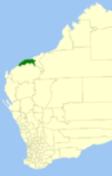
The Shire of Roebourne is one of the four Local Government Area
s in the Pilbara region of Western Australia
. The Shire covers an area of 15882 square kilometres (6,132 sq mi) and has a population of about 19,100 (June 2010), most of which is located in its seat of government, the town of Karratha
, and the major towns.
Local Government Areas of Western Australia
The Australian state of Western Australia is divided into 141 local government areas...
s in the Pilbara region of Western Australia
Western Australia
Western Australia is a state of Australia, occupying the entire western third of the Australian continent. It is bounded by the Indian Ocean to the north and west, the Great Australian Bight and Indian Ocean to the south, the Northern Territory to the north-east and South Australia to the south-east...
. The Shire covers an area of 15882 square kilometres (6,132 sq mi) and has a population of about 19,100 (June 2010), most of which is located in its seat of government, the town of Karratha
Karratha, Western Australia
-Facilities:A range of hotel, motel, B&B and caravan/RV accommodation is available for visitors. However, as the town is booming, accommodation is often hard to come by.The town has restaurants, a tavern, two hotels and two night clubs...
, and the major towns.
History
In 1887, the Municipality of Roebourne, and the Cossack and Roebourne Road Districts all came into being. As the Roebourne region's population declined, the three merged into the Roebourne Road District in 1910. On 1 July 1961, it became the Shire of Roebourne under the Local Government Act 1960.Wards
The Shire is divided into wards:- Karratha (6 councillors)
- Wickham, Point Samson and Cossack (2 councillors)
- Dampier (2 councillors)
- Roebourne/Pastoral (1 councillor)
Towns
- CossackCossack, Western AustraliaCossack is an historic ghost town located 1,480 km north of Perth and 15 km from Roebourne in the Pilbara region of Western Australia. The nearest town to Cossack is Wickham. At the 2006 census, Cossack had a population of 236....
- DampierDampier, Western AustraliaDampier is a major industrial port in the north-west of Western Australia. The Dampier Port is part of the Dampier Archipelago. The port services petrochemical, salt, iron ore and natural gas export industries. Rio Tinto exports large volumes of iron ore through the port, and in September 2010...
- KarrathaKarratha, Western Australia-Facilities:A range of hotel, motel, B&B and caravan/RV accommodation is available for visitors. However, as the town is booming, accommodation is often hard to come by.The town has restaurants, a tavern, two hotels and two night clubs...
- Point SamsonPoint Samson, Western Australia,Point Samson is a small coastal hamlet 1,579 km north of Perth and 18 km north of Roebourne in the Pilbara region of Western Australia. The town is a popular holiday location for the nearby mining towns, including Wickham, Karratha and Dampier. Fishing is the main industry...
- RoebourneRoebourne, Western AustraliaRoebourne is an old gold rush town in Western Australia's Pilbara region. It is 202 km from Port Hedland and 1,563 km from Perth, the state's capital. It prospered during its gold boom of the late 19th century and was once the biggest settlement between Darwin and Perth...
- Whim CreekWhim Creek, Western AustraliaWhim Creek is a small town in Western Australia.Originally a post office known as "Whim Well", Whim Creek is on the North West Coastal Highway midway between Karratha and Port Hedland...
- WickhamWickham, Western AustraliaWickham is a townsite located 1,572 km north of Perth and 13 km north of Roebourne in the Pilbara region of Western Australia.-History:...