
Shire of Nungarin
Encyclopedia
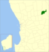
The Shire of Nungarin is a Local Government Area
in the Wheatbelt region of Western Australia
, and, with a population of 264 as at the 2001 census, is one of the nation's smallest. It is located about 40 kilometres (25 mi) north of Merredin
and about 300 kilometres (186 mi) east of the state capital, Perth
. The Shire covers an area of 1164 square kilometres (449 sq mi), and its seat of government is the town of Nungarin
.
Local Government Areas of Western Australia
The Australian state of Western Australia is divided into 141 local government areas...
in the Wheatbelt region of Western Australia
Western Australia
Western Australia is a state of Australia, occupying the entire western third of the Australian continent. It is bounded by the Indian Ocean to the north and west, the Great Australian Bight and Indian Ocean to the south, the Northern Territory to the north-east and South Australia to the south-east...
, and, with a population of 264 as at the 2001 census, is one of the nation's smallest. It is located about 40 kilometres (25 mi) north of Merredin
Merredin, Western Australia
-Economy:The agricultural land around Merredin produces 40% of Western Australia’s wheat quota. As a focal point for the region, Merredin’s local bulk handling co-operative receives and processes in excess of a million tonnes of grain every year...
and about 300 kilometres (186 mi) east of the state capital, Perth
Perth, Western Australia
Perth is the capital and largest city of the Australian state of Western Australia and the fourth most populous city in Australia. The Perth metropolitan area has an estimated population of almost 1,700,000....
. The Shire covers an area of 1164 square kilometres (449 sq mi), and its seat of government is the town of Nungarin
Nungarin, Western Australia
Nungarin is a town located in the North Eastern Wheatbelt region of Western Australia, approximately east of Perth and north of Merredin. It is the main town in the Shire of Nungarin. At the 2006 census, Nungarin had a population of 142.-History:...
.
History
Initially, Nungarin was governed by the Kellerberrin Road Board. In 1911, responsibility for the area was transferred to the Merredin Road Board. In 1921, the Nungarin Road Board was gazetted, which extended north into the present Mount Marshall shire. In 1933 it lost over three-quarters of its land area with the formation of Mukinbudin Road District. On 1 July 1961, it became the Shire of Nungarin following changes to the Local Government Act.Wards
The shire has been divided into 3 wards. Prior to the elections in May 2003, there were 7 wards.- Central Ward (3 councillors)
- Kwelkan/Danberrin/Elabbin Ward (2 councillors)
- Mangowine/Campion/Knungajin Ward (2 councillors)
Towns and localities
- NungarinNungarin, Western AustraliaNungarin is a town located in the North Eastern Wheatbelt region of Western Australia, approximately east of Perth and north of Merredin. It is the main town in the Shire of Nungarin. At the 2006 census, Nungarin had a population of 142.-History:...
- Burran Rock
- ChandlerChandler, Western AustraliaChandler is an abandoned townsite between Merredinand Mukinbudin in the Wheatbelt region of Western Australia.Initially established to servise the nearby Alunite, a source of potash, mine at nearby Lake Campion land was set aside in 1942 for a townsite. Lots were surveyed soon afterward and the...
- ElabbinElabbin, Western AustraliaElabbin is a small town between Merredinand Mukinbudin in the Wheatbelt region of Western Australia.Originating as a railway siding on the Dowerin to Merredin railway line when constructed in 1912...
- Kwelkan
- Mangowine
- Talgomine