
Shire of Northampton
Encyclopedia
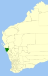
The Shire of Northampton is a Local Government Area
in the Mid West region of Western Australia
, about 50 kilometres (31 mi) north of Geraldton and about 460 kilometres (286 mi) north of the state capital, Perth
. The Shire covers an area of 13738 square kilometres (5,304 sq mi), and its seat of government is the town of Northampton
, with the largest settlement being Kalbarri
.
The Principality of Hutt River, a micronation
which is not recognised by the Australian or Western Australian governments, is located within the Shire.
Prior to May 2003, the Coastal Ward was known as the Horrocks Ward, the Kalbarri Ward had 3 councillors and all the others had two councillors.
Local Government Areas of Western Australia
The Australian state of Western Australia is divided into 141 local government areas...
in the Mid West region of Western Australia
Western Australia
Western Australia is a state of Australia, occupying the entire western third of the Australian continent. It is bounded by the Indian Ocean to the north and west, the Great Australian Bight and Indian Ocean to the south, the Northern Territory to the north-east and South Australia to the south-east...
, about 50 kilometres (31 mi) north of Geraldton and about 460 kilometres (286 mi) north of the state capital, Perth
Perth, Western Australia
Perth is the capital and largest city of the Australian state of Western Australia and the fourth most populous city in Australia. The Perth metropolitan area has an estimated population of almost 1,700,000....
. The Shire covers an area of 13738 square kilometres (5,304 sq mi), and its seat of government is the town of Northampton
Northampton, Western Australia
Northampton is a town north of Geraldton, in the Mid West region of Western Australia. At the 2006 census, the town had a population of 813. It is historic, with an outstanding National Trust building. The town lies on the North West Coastal Highway. Formerly named Gwalla after the location's...
, with the largest settlement being Kalbarri
Kalbarri, Western Australia
Kalbarri is a coastal town in the Mid West region located 592 km north of Perth, Western Australia. The town is found at the mouth of the Murchison River and has an elevation of...
.
The Principality of Hutt River, a micronation
Micronation
Micronations, sometimes also referred to as model countries and new country projects, are entities that claim to be independent nations or states but which are not recognized by world governments or major international organizations...
which is not recognised by the Australian or Western Australian governments, is located within the Shire.
History
The Mines Road District was constituted on 25 January 1871 under the Road Boards Act 1871. It was renamed Northampton on 10 February 1887. On 1 July 1961, it became a Shire under the Local Government Act 1960.Wards
The shire is divided into 6 wards, most of which have 1 councillor each:- Kalbarri Ward (4 councillors)
- Central Ward (3 councillors)
- Coastal Ward
- North East Ward
- South East Ward
- West Ward
Prior to May 2003, the Coastal Ward was known as the Horrocks Ward, the Kalbarri Ward had 3 councillors and all the others had two councillors.
Towns and localities
- NorthamptonNorthampton, Western AustraliaNorthampton is a town north of Geraldton, in the Mid West region of Western Australia. At the 2006 census, the town had a population of 813. It is historic, with an outstanding National Trust building. The town lies on the North West Coastal Highway. Formerly named Gwalla after the location's...
- AjanaAjana, Western AustraliaAjana is a small town in Western Australia located on the Ajana Back Road north-west of Perth in the Mid West RegionThe name of the town is Aboriginal in origin and is thought either to be the local name for the area or to come from the Aboriginal word meaning "mine".The townsite was declared in...
- Alma
- BinnuBinnu, Western AustraliaBinnu is a town located on the North West Coastal Highway in the Mid West region of Western Australia.The name derives from a well on the outskirts of town that was first in use in 1909. The name is Indigenous Australian in origin and is thought to mean either to squeeze or place of emus...
- East Bowes
- Galena
- HorrocksHorrocks, Western AustraliaHorrocks also known as Horrocks Beach is a town in the Mid West region of Western Australia. It is located north of the state capital, Perth and the closest populated town is Northampton....
- Houtman AbrolhosHoutman AbrolhosThe Houtman Abrolhos is a chain of 122 islands, and associated coral reefs, in the Indian Ocean off the west coast of Australia. Nominally located at , it lies about eighty kilometres west of Geraldton, Western Australia...
- IssekaIsseka, Western AustraliaIsseka is a small town in the Mid West region of Western Australia.Located on the North West Coastal Highway the town is also close to the Bowes River....
- KalbarriKalbarri, Western AustraliaKalbarri is a coastal town in the Mid West region located 592 km north of Perth, Western Australia. The town is found at the mouth of the Murchison River and has an elevation of...
- Kalbarri National ParkKalbarri National ParkKalbarri National Park is located north of Perth. The major geographical features of the park include the Murchison River gorge which runs for nearly 80 kilometres on the lower reaches of the Murchison River...
- LyntonLynton, Western AustraliaLynton is a small town located in the Mid West region of Western Australia. It is situated between the towns of Northampton and Kalbarri and near the mouth of the Hutt River....
- Ogilvie
- Port GregoryPort Gregory, Western AustraliaGregory is a small town and fishing port in the Mid West region of Western Australia. At the 2006 census, Gregory had a population of 46.Port Gregory, located close to the mouth of the Hutt River, was established in 1849 and named after brothers Augustus and Frank Gregory, two of Western...
- Sandy Gully
- Yallabatharra
Population
The population of the Shire of Northampton as at the 2006 census was 3,204 (Usual Residents) or 4,085 (Place of Enumeration). The disparity is due to holiday accommodation in Kalbarri being picked up in the latter count.| Year | Population |
|---|---|
| 1911 | 1,412 |
| 1921 | 1,518 |
| 1933 | 1,677 |
| 1947 | 1,470 |
| 1954 | 1,753 |
| 1961 | 1,821 |
| 1966 | 2,021 |
| 1971 | 2,142 |
| 1976 | 2,422 |
| 1981 | 2,366 |
| 1986 | 3,034 |
| 1991 | 3,480 |
| 1996 | 3,697 |
| 2001 | 4,136 |
| 2006 | 4,085 |