
Shire of Northam
Encyclopedia
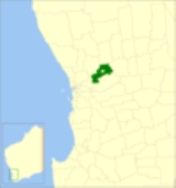
The Shire of Northam is a Local Government Area
in the Wheatbelt region of Western Australia
, beyond the northeastern fringe of the Perth
metropolitan area centred on the town of Northam
itself. The Shire covers an area of 1431 square kilometres (553 sq mi). In 2007, it merged with the Town of Northam
, almost tripling its population in the process from a previous size of 3,794 (ABS 2006).
. The town expanded beyond the municipal boundaries (which were set at about 5 km² (1.9 sq mi)) and on 6 September 1957, the municipal boundaries were adjusted to bring all of Northam under it. The Road District lost a significant part of its population in this transfer.
On 1 July 1961, the Road District became a Shire under the Local Government Act 1960.
, and on 31 October 2006, the Local Government Advisory Board received a proposal to that effect from both councils. Public meetings in December 2006 announced that the new council would be known as the Shire of Northam, and would come into existence on 1 July 2007, initially operated by a board of commissioners (two from each entity plus an independent chair)..
In January 2007, the Local Government Advisory Board officially recommended to the Minister for Local Government that the amalgamation proceed. The Shire electors successfully petitioned for a referendum within their area, which was held on 28 April 2007. Prior to the election, the Shire of Northam itself took the unusual step of asking its electors not to vote, in order to deny the referendum the 50% of voters needed to constitute a valid poll under Clause 10 of Schedule 2.1 of the Local Government Act 1995
. With a participation rate of 23.59%, a majority of 93% voted against the proposal. This 23.59% voter participation equates to 596 voters; less than the number that petitioned for the referendum in the first place.
The amalgamation proceeded as planned and the first elections for seats in the new council were held in October 2007.
Local Government Areas of Western Australia
The Australian state of Western Australia is divided into 141 local government areas...
in the Wheatbelt region of Western Australia
Western Australia
Western Australia is a state of Australia, occupying the entire western third of the Australian continent. It is bounded by the Indian Ocean to the north and west, the Great Australian Bight and Indian Ocean to the south, the Northern Territory to the north-east and South Australia to the south-east...
, beyond the northeastern fringe of the Perth
Perth, Western Australia
Perth is the capital and largest city of the Australian state of Western Australia and the fourth most populous city in Australia. The Perth metropolitan area has an estimated population of almost 1,700,000....
metropolitan area centred on the town of Northam
Northam, Western Australia
Northam is a town in Western Australia, situated at the confluence of the Avon and Mortlock Rivers, about north-east of Perth in the Avon Valley. At the 2006 census, Northam had a population of 6,009. Northam is the largest town in the Avon region...
itself. The Shire covers an area of 1431 square kilometres (553 sq mi). In 2007, it merged with the Town of Northam
Town of Northam
The Town of Northam was a Local Government Area of Western Australia for the town of Northam in the Wheatbelt region of Western Australia, north-east of the capital, Perth along Great Eastern Highway...
, almost tripling its population in the process from a previous size of 3,794 (ABS 2006).
History
In 1871, the Northam Road District was constituted under the Road Boards Act 1871. On 4 November 1879, the separate Northam Municipality was constituted to manage the town of NorthamNortham, Western Australia
Northam is a town in Western Australia, situated at the confluence of the Avon and Mortlock Rivers, about north-east of Perth in the Avon Valley. At the 2006 census, Northam had a population of 6,009. Northam is the largest town in the Avon region...
. The town expanded beyond the municipal boundaries (which were set at about 5 km² (1.9 sq mi)) and on 6 September 1957, the municipal boundaries were adjusted to bring all of Northam under it. The Road District lost a significant part of its population in this transfer.
On 1 July 1961, the Road District became a Shire under the Local Government Act 1960.
Amalgamation
In September 2006, the Shire received a report into the possibility of merging with the Town of NorthamTown of Northam
The Town of Northam was a Local Government Area of Western Australia for the town of Northam in the Wheatbelt region of Western Australia, north-east of the capital, Perth along Great Eastern Highway...
, and on 31 October 2006, the Local Government Advisory Board received a proposal to that effect from both councils. Public meetings in December 2006 announced that the new council would be known as the Shire of Northam, and would come into existence on 1 July 2007, initially operated by a board of commissioners (two from each entity plus an independent chair)..
In January 2007, the Local Government Advisory Board officially recommended to the Minister for Local Government that the amalgamation proceed. The Shire electors successfully petitioned for a referendum within their area, which was held on 28 April 2007. Prior to the election, the Shire of Northam itself took the unusual step of asking its electors not to vote, in order to deny the referendum the 50% of voters needed to constitute a valid poll under Clause 10 of Schedule 2.1 of the Local Government Act 1995
Local Government Act 1995
The Local Government Act 1995 is an act of the Western Australian Parliament which lays down the responsibilities, powers and procedures for election of Local Government Bodies.-External links:*...
. With a participation rate of 23.59%, a majority of 93% voted against the proposal. This 23.59% voter participation equates to 596 voters; less than the number that petitioned for the referendum in the first place.
The amalgamation proceeded as planned and the first elections for seats in the new council were held in October 2007.
Wards
The shire has been divided into 4 wards.- Town Ward (5 councillors)
- Central Ward (2 councillors)
- West Ward (2 councillors)
- East Ward (1 councillors)
Towns and localities
- Bakers HillBakers Hill, Western AustraliaBakers Hill is a town east of Perth, Western Australia on the Great Eastern Highway. The town is located within the Shire of Northam, between Wundowie and Clackline. At the 2006 census, Bakers Hill had a population of 637.-History:...
- Buckland
- Burlong
- ClacklineClackline, Western AustraliaClackline is a locality in the Wheatbelt region of Western Australia, about east-north-east of Perth.John Forrest, later Premier of Western Australia, recorded the name in 1879 but the origin of the word is unknown...
- Copley
- Grass ValleyGrass Valley, Western AustraliaGrass Valley is a small townsite east of Northam, Western Australia in the Avon Valley area.The town is named after a local property of the same name that was established in 1833 by William Nairn....
- Irishtown
- Jennapullin
- Meenaar
- Mokine
- Muresk
- NorthamNortham, Western AustraliaNortham is a town in Western Australia, situated at the confluence of the Avon and Mortlock Rivers, about north-east of Perth in the Avon Valley. At the 2006 census, Northam had a population of 6,009. Northam is the largest town in the Avon region...
- Southern Brook
- Spencers BrookSpencers Brook, Western AustraliaSpencers Brook is a district in Western Australia located between the towns of Northam and York, about east of the state capital, Perth. At the 2006 census, Spencers Brook had a population of 195....
- Throssell
- Woottating
- WundowieWundowie, Western AustraliaWundowie is a town in Western Australia located between Perth and Northam in the Darling Range. It was the location of an iron works, and siding and stopping place on the Eastern Railway....
Population
The historic populations of the area which now forms the Shire of Northam are as follows. "Old Shire" relates to the pre-2007 boundaries.| Year | Population | ||
|---|---|---|---|
| Combined | Town | Old Shire | |
| 1911 | 5,146 | 3,361 | 1,785 |
| 1921 | 5,755 | 3,602 | 2,153 |
| 1933 | 7,019 | 4,817 | 2,202 |
| 1947 | 6,934 | 4,652 | 2,282 |
| 1954 | 10,307 | 5,725 | 4,582 |
| 1961 | 9,993 | 7,200 | 2,793 |
| 1966 | 10,094 | 7,400 | 2,694 |
| 1971 | 9,543 | 7,117 | 2,426 |
| 1976 | 9,385 | 6,846 | 2,539 |
| 1981 | 9,533 | 6,944 | 2,589 |
| 1986 | 9,338 | 6,887 | 2,451 |
| 1991 | 9,428 | 6,549 | 2,879 |
| 1996 | 9,485 | 6,285 | 3,200 |
| 2001 | 9,702 | 6,137 | 3,565 |
| 2006 | 9,803 | 6,009 | 3,794 |