
Shire of Nannup
Encyclopedia
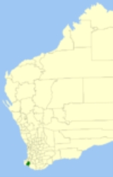
The Shire of Nannup is a Local Government Area
in the South West region of Western Australia
, approximately 280 kilometres (174 mi) south of the state capital, Perth
and 60 kilometres (37 mi) southeast of the coastal resort town of Busselton
. Its seat of government is the town of Nannup
, where about half of the Shire's population reside.
The Shire has a land area of 2935 square kilometres (1,133 sq mi), about 85% of which is covered in hardwood jarrah, karri and marri
forests, while the southern coastline is mostly within the D'Entrecasteaux National Park
.
Local Government Areas of Western Australia
The Australian state of Western Australia is divided into 141 local government areas...
in the South West region of Western Australia
Western Australia
Western Australia is a state of Australia, occupying the entire western third of the Australian continent. It is bounded by the Indian Ocean to the north and west, the Great Australian Bight and Indian Ocean to the south, the Northern Territory to the north-east and South Australia to the south-east...
, approximately 280 kilometres (174 mi) south of the state capital, Perth
Perth, Western Australia
Perth is the capital and largest city of the Australian state of Western Australia and the fourth most populous city in Australia. The Perth metropolitan area has an estimated population of almost 1,700,000....
and 60 kilometres (37 mi) southeast of the coastal resort town of Busselton
Busselton, Western Australia
-Growth and development:According to the Australian Bureau of Statistics the Shire had a permanent resident population of 25,950 in 2004 with the town of Busselton accounting for 67% or 17,400 of the total. The Shire's permanent population is expected to continue to increase significantly to...
. Its seat of government is the town of Nannup
Nannup, Western Australia
Nannup is a town and shire in the South West region of Western Australia, approximately south of Perth on the Blackwood River at the crossroads of Vasse Highway and Brockman Highway, linking Nannup to most of the Lower South West's regional centres...
, where about half of the Shire's population reside.
The Shire has a land area of 2935 square kilometres (1,133 sq mi), about 85% of which is covered in hardwood jarrah, karri and marri
Corymbia calophylla
Corymbia calophylla is a bloodwood native to Western Australia. Common names include Marri and Port Gregory Gum, and a long standing usage has been Red Gum due to the red gum effusions often found on trunks.It is distinctive among bloodwoods for its very large buds and fruit Corymbia calophylla...
forests, while the southern coastline is mostly within the D'Entrecasteaux National Park
D'Entrecasteaux National Park
D'Entrecasteaux National Park is a national park in Western Australia , south of Perth. The park is named after the French Admiral Bruni D'Entrecasteaux who was the first European to sight the area and name Point D'Entrecasteaux in 1792....
.
History
The Lower Blackwood Road Board (renamed to Nannup Road Board in 1925) was gazetted in 1890. On 1 July 1961, it became the Nannup Shire Council following changes to the Local Government Act.Wards
The Shire has been divided into 3 wards.- Central Ward (3 councillors)
- North Ward (3 councillors)
- South Ward (2 councillors)
Towns
- NannupNannup, Western AustraliaNannup is a town and shire in the South West region of Western Australia, approximately south of Perth on the Blackwood River at the crossroads of Vasse Highway and Brockman Highway, linking Nannup to most of the Lower South West's regional centres...
- Carlotta
- Cundinup
- Donnelly RiverDonnelly River, Western AustraliaDonnelly River is a former town and present-day holiday village located in the South West region of Western Australia, at a point between Nannup, Bridgetown and Manjimup on the Donnelly River, a small river which flows into the Southern Ocean...
(Wheatley) - Jalbarragup
- Peerabeelup