
Shire of Murchison
Encyclopedia
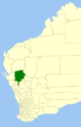
The Shire of Murchison is a large agricultural region in the central part of Western Australia
, and is the only shire in Australia without a town. At the 2006 Census, it was also the least populous Local Government Area in Western Australia.
s and goat stations - also known as pastoral lease
s. The population of the shire is very scattered with only 200 inhabitants in the region.
This sparse population is one factor behind the Shire being one of the two shortlisted sites for the Square Kilometre Array
- a proposed radio telescope with a total collecting area of one square kilometre. It is also home to the Murchison Widefield Array
.
A residence for the Shire Clerk was built in 1966 approximately 200 km north of the town of Mullewa
. This building included a shire office. In 1985 a Roadhouse and new Shire offices which include a museum were built; this area was gazetted as the Murchison Settlement in 1988.
Prior to 2005, there were 4 wards - Boolardy, Byro, Mileura and Yallalong.
Western Australia
Western Australia is a state of Australia, occupying the entire western third of the Australian continent. It is bounded by the Indian Ocean to the north and west, the Great Australian Bight and Indian Ocean to the south, the Northern Territory to the north-east and South Australia to the south-east...
, and is the only shire in Australia without a town. At the 2006 Census, it was also the least populous Local Government Area in Western Australia.
Description
The region is related to the catchment area of the Murchison River. It has extensive mining areas, some of which are active - with a large number of older abandoned workings. The region has large sheep stationSheep station
A sheep station is a large property in Australia or New Zealand whose main activity is the raising of sheep for their wool and meat. In Australia, sheep stations are usually in the south-east or south-west of the country. In New Zealand the Merinos are usually in the high country of the South...
s and goat stations - also known as pastoral lease
Pastoral lease
A pastoral lease is Crown land that government allows to be leased, generally for the purposes of farming.-Australia:Pastoral leases exist in both Australian commonwealth law and state jurisdictions....
s. The population of the shire is very scattered with only 200 inhabitants in the region.
This sparse population is one factor behind the Shire being one of the two shortlisted sites for the Square Kilometre Array
Square Kilometre Array
The Square Kilometre Array is a radio telescope in development which will have a total collecting area of approximately one square kilometre. It will operate over a wide range of frequencies and its size will make it 50 times more sensitive than any other radio instrument...
- a proposed radio telescope with a total collecting area of one square kilometre. It is also home to the Murchison Widefield Array
Murchison Widefield Array
The Murchison Widefield Array is a joint project between MIT, the Harvard-Smithsonian Center for Astrophysics, the Raman Research Institute and an Australian consortium of universities, to build a low-frequency radio array operating in the frequency range 80-300 MHz...
.
History
In 1875, the Murchison Road Board was gazetted. On 1 July 1961, it became the Shire Council following changes to the Local Government Act.A residence for the Shire Clerk was built in 1966 approximately 200 km north of the town of Mullewa
Mullewa, Western Australia
- External links :* *...
. This building included a shire office. In 1985 a Roadhouse and new Shire offices which include a museum were built; this area was gazetted as the Murchison Settlement in 1988.
Wards
The shire is represented by 7 councillors, and has been divided into two wards. The shire president is elected from among the councillors.- Darlot Ward (4 councillors)
- Ballinyoo Ward (3 councillors)
Prior to 2005, there were 4 wards - Boolardy, Byro, Mileura and Yallalong.