
Shire of Moora
Encyclopedia
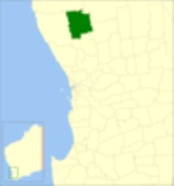
The Shire of Moora is a Local Government Area
in the northern Wheatbelt region of Western Australia
, and generally lies between the Brand Highway
and Great Northern Highway
about 180 kilometres (112 mi) north of Perth
, the state capital. The Shire covers an area of 3767 square kilometres (1,454 sq mi) and its seat of government is the town of Moora
.
Until 20 October 2007, the shire was divided into several wards, most with 1 councillor each:
Local Government Areas of Western Australia
The Australian state of Western Australia is divided into 141 local government areas...
in the northern Wheatbelt region of Western Australia
Western Australia
Western Australia is a state of Australia, occupying the entire western third of the Australian continent. It is bounded by the Indian Ocean to the north and west, the Great Australian Bight and Indian Ocean to the south, the Northern Territory to the north-east and South Australia to the south-east...
, and generally lies between the Brand Highway
Brand Highway
Brand Highway is a 362 kilometre main highway linking the northern outskirts of Perth, the capital of Western Australia, to the port city of Geraldton in Western Australia's Mid West region. Together with North West Coastal Highway, it forms part of the Western Australian coastal link to the...
and Great Northern Highway
Great Northern Highway
The Great Northern Highway is a generally north-south Western Australian highway which links the state's capital Perth with its most northern port, Wyndham. It is in length, with being National Highway...
about 180 kilometres (112 mi) north of Perth
Perth, Western Australia
Perth is the capital and largest city of the Australian state of Western Australia and the fourth most populous city in Australia. The Perth metropolitan area has an estimated population of almost 1,700,000....
, the state capital. The Shire covers an area of 3767 square kilometres (1,454 sq mi) and its seat of government is the town of Moora
Moora, Western Australia
Moora is a townsite located 177 km north of Perth in the Wheatbelt region of Western Australia. Moora was one of the original stations on the Midland railway line to Walkaway, and the townsite was gazetted in 1895...
.
History
In 1908, the Moora Road District was created out of land from Victoria Plains. On 1 July 1961, it became a Shire under the Local Government Act 1960.Wards
The shire is undivided and the nine councillors represent the entire shire.Until 20 October 2007, the shire was divided into several wards, most with 1 councillor each:
- Moora Town Ward (4 councillors)
- Bindi Bindi
- Coomberdale
- Koojan
- Miling
- Watheroo
Towns and localities
- Bindi BindiBindi Bindi, Western AustraliaBindi Bindi is a small town located between Moora and Wongan Hills in the Wheatbelt region of Western Australia.The town originated as a Western Australian Government Railways siding and was gazetted in 1947. The name is Aboriginal in origin and is the word for stick or skewer with which a coat...
- CoomberdaleCoomberdale, Western AustraliaCoomberdale is a small town located along the Midlands Road between Moora and Watheroo in the Wheatbelt region of Western Australia.The Midland Railway Company constructed a railway siding in 1895 when the Midland to Walkaway line was opened...
- KoojanKoojan, Western AustraliaKoojan is a small town located between Moora and Bindoon in the Wheatbelt region of Western Australia.When the Midland railway was opened in 1894 the site of the present town was established as a railway siding. Some time afterward the area was surveyed and subdivided and the town was gazeted in...
- MilingMiling, Western AustraliaMiling is a small town in the Shire of Moora, north of Perth, Western Australia. At the 2006 census, Miling had a population of 205.-Notes and references:* Seymour, A. L. The development of Miling. Miling [W.A.] : A.L. Seymour...
- MooraMoora, Western AustraliaMoora is a townsite located 177 km north of Perth in the Wheatbelt region of Western Australia. Moora was one of the original stations on the Midland railway line to Walkaway, and the townsite was gazetted in 1895...
- WalebingWalebing, Western AustraliaWalebing is a small town in the wheatbelt region of Western Australia. Located at in the Shire of Moora, it takes its name from the original homestead established by Anthony O'Grady Lefroy in the 1840s....
- WatherooWatheroo, Western AustraliaWatheroo in a small town in the Mid West region of Western Australia.Land in the area was settled by James Oliver in 1851, the area was surveyed in 1871 and the name Watheroo was charted for the first....
Population
| Year | Population |
|---|---|
| 1911 | 1,921 |
| 1921 | 1,642 |
| 1933 | 2,088 |
| 1947 | 2,006 |
| 1954 | 2,896 |
| 1961 | 3,082 |
| 1966 | 2,981 |
| 1971 | 3,120 |
| 1976 | 3,040 |
| 1981 | 3,102 |
| 1986 | 2,828 |
| 1991 | 2,654 |
| 1996 | 2,541 |
| 2001 | 2,557 |
| 2006 | 2,410 |