
Shire of Meekatharra
Encyclopedia
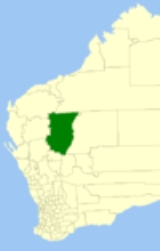
The Shire of Meekatharra is a Local Government Area
in the Mid West region of Western Australia
, about halfway between the town of Port Hedland
and the state capital, Perth, Western Australia
. The Shire covers an area of 100789 square kilometres (38,915 sq mi), and its seat of government is the town of Meekatharra
.
Local Government Areas of Western Australia
The Australian state of Western Australia is divided into 141 local government areas...
in the Mid West region of Western Australia
Western Australia
Western Australia is a state of Australia, occupying the entire western third of the Australian continent. It is bounded by the Indian Ocean to the north and west, the Great Australian Bight and Indian Ocean to the south, the Northern Territory to the north-east and South Australia to the south-east...
, about halfway between the town of Port Hedland
Port Hedland, Western Australia
Port Hedland is the highest tonnage port in Australia and largest town in the Pilbara region of Western Australia, with a population of approximately 14,000 ....
and the state capital, Perth, Western Australia
Perth, Western Australia
Perth is the capital and largest city of the Australian state of Western Australia and the fourth most populous city in Australia. The Perth metropolitan area has an estimated population of almost 1,700,000....
. The Shire covers an area of 100789 square kilometres (38,915 sq mi), and its seat of government is the town of Meekatharra
Meekatharra, Western Australia
Meekatharra is a town in the Mid West region of Western Australia. Meekatharra is an Australian Aboriginal word meaning 'place of little water'. At the 2006 census, Meekatharra had a population of 798, with 44.0% being Aboriginal....
.
History
The Meekatharra Road Board was gazetted in 1909. On 1 July 1961, it became a Shire Council following changes to the Local Government Act.Wards
The shire is divided into 3 wards:- Town Ward (5 councillors)
- Nannine Ward (2 councillors)
- Peak Hill Ward (2 councillors)
Towns and localities
- MeekatharraMeekatharra, Western AustraliaMeekatharra is a town in the Mid West region of Western Australia. Meekatharra is an Australian Aboriginal word meaning 'place of little water'. At the 2006 census, Meekatharra had a population of 798, with 44.0% being Aboriginal....
- AbbottsAbbotts, Western AustraliaAbbotts is an abandoned town in Western Australia located in the Murchison Goldfields region of Western Australia located 31 km north-west of Meekatharra on the Meekatharra - Mount Clere Road....
- Capricorn
- GabaninthaGabanintha, Western AustraliaGabanintha is a ghost town located in the Mid West region of Western Australia approximately 40km South East of Meekatharra on the Meekatharra-Sandstone road. The town is situated within the Murchison goldfields....
- HorseshoeHorseshoe, Western AustraliaHorseshoe is an abandoned town in Western Australia located in the Murchison goldfields within the Mid West region of Western Australia situated between Meekatharra and Newman. The town is adjacent to the Peak Hill goldfields....
- KumarinaKumarina, Western AustraliaKumarina is a town located in Western Australia along the Great Northern Highway between the towns of Meekatharra and Newman. It contains a roadhouse and a caravan park, as well as a small wildlife sanctuary, tavern, motel and restaurant....
- NannineNannine, Western AustraliaNannine is a ghost town in the Mid West region of Western Australia. It is located on the northern bank of Lake Anneen, approximately 35 kilometres south-southwest of Meekatharra, and 735 kilometres north-northeast of Perth....
- Peak HillPeak Hill, Western AustraliaPeak Hill is the name of a goldfield, locality and the site of a gold mining ghost town in the Murchison Region of Western Australia. The gold mine covers 2,162 hectares and consists of four open-cut mines, titled Main, Jubilee, Fiveways and Harmony....
- PorlellPorlell, Western AustraliaPorlell is a ghost town located in the Mid West region of Western Australia. It is found between the towns of Nannine and Gabanintha. The town is situated within the Murchison goldfields....