
Shire of Kulin
Encyclopedia
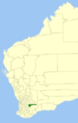
The Shire of Kulin is a Local Government Area
in the Eastern Wheatbelt region of Western Australia
, about 300 kilometres (186 mi) ESE of the state capital, Perth
. The Shire's land area of 4714 square kilometres (1,820 sq mi) forms a narrow east-west band, located between the Shire of Kondinin
to the north and the Shire of Lake Grace
to the south. Its seat of government is the town of Kulin
. The local economy is based on agriculture - predominantly cereal grains and sheep.
From 1964 until 3 May 2003, the following system existed:
Local Government Areas of Western Australia
The Australian state of Western Australia is divided into 141 local government areas...
in the Eastern Wheatbelt region of Western Australia
Western Australia
Western Australia is a state of Australia, occupying the entire western third of the Australian continent. It is bounded by the Indian Ocean to the north and west, the Great Australian Bight and Indian Ocean to the south, the Northern Territory to the north-east and South Australia to the south-east...
, about 300 kilometres (186 mi) ESE of the state capital, Perth
Perth, Western Australia
Perth is the capital and largest city of the Australian state of Western Australia and the fourth most populous city in Australia. The Perth metropolitan area has an estimated population of almost 1,700,000....
. The Shire's land area of 4714 square kilometres (1,820 sq mi) forms a narrow east-west band, located between the Shire of Kondinin
Shire of Kondinin
The Shire of Kondinin is a Local Government Area in the Eastern Wheatbelt region of Western Australia, about east of the state capital, Perth. The Shire's land area of forms a narrow east-west band, located between the Shire of Narembeen to the north and the Shire of Kulin to the south...
to the north and the Shire of Lake Grace
Shire of Lake Grace
The Shire of Lake Grace is a Local Government Area in the Eastern Wheatbelt region of Western Australia, about ESE of the state capital, Perth. The Shire has a land area of and its seat of government is the town of Lake Grace.-History:...
to the south. Its seat of government is the town of Kulin
Kulin, Western Australia
Kulin is a town located in the Eastern Wheatbelt region of Western Australia, approximately 280 km from Perth. It is the main town in the Shire of Kulin.- History :...
. The local economy is based on agriculture - predominantly cereal grains and sheep.
History
On 14 June 1918, the Roe Road District was gazetted. It was renamed to the Kulin Road District on 12 March 1926. On 1 July 1961, it became a Shire under the Local Government Act 1960.Wards
The shire has been divided into 4 wards.- Town Ward (3 councillors)
- West Ward (3 councillors)
- Central Ward (2 councillors)
- East Ward (1 councillor)
From 1964 until 3 May 2003, the following system existed:
- Town Ward
- Central Ward
- Dudinin Ward
- East Ward
- Jitarning Ward
- Kulin Rock Ward
Towns and localities
- KulinKulin, Western AustraliaKulin is a town located in the Eastern Wheatbelt region of Western Australia, approximately 280 km from Perth. It is the main town in the Shire of Kulin.- History :...
- Dudinin
- Holt RockHolt Rock, Western AustraliaHolt Rock is a small town in the Wheatbelt region of Western Australia. It is situated between the towns of Hyden and Varley close to the edge of Lake Hurlstone....
- Jitarning
- PingaringPingaring, Western AustraliaPingaring is a small town in the Wheatbelt region of Western Australia.The name of the town is the Indigenous Australian name of a nearby spring that was first recorded by surveyors in 1926....
Population
| Year | Population |
|---|---|
| 1921 | 1,121 |
| 1933 | 1,274 |
| 1947 | 873 |
| 1954 | 1,168 |
| 1961 | 1,261 |
| 1966 | 1,393 |
| 1971 | 1,260 |
| 1976 | 1,289 |
| 1981 | 1,275 |
| 1986 | 1,162 |
| 1991 | 1,062 |
| 1996 | 890 |
| 2001 | 839 |
| 2006 | 881 |