
Shire of Kojonup
Encyclopedia
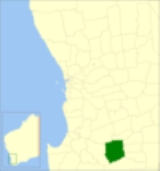
The Shire of Kojonup is a Local Government Area
in the Great Southern region of Western Australia
, about 250 kilometres (155 mi) southeast of the state capital, Perth
, along Albany Highway
. The Shire covers an area of 2932 square kilometres (1,132 sq mi) and its seat of government is the town of Kojonup
.
(Note: The town of Ongerup
, unrelated to the ward, is located within the Shire of Gnowangerup
.)
Local Government Areas of Western Australia
The Australian state of Western Australia is divided into 141 local government areas...
in the Great Southern region of Western Australia
Western Australia
Western Australia is a state of Australia, occupying the entire western third of the Australian continent. It is bounded by the Indian Ocean to the north and west, the Great Australian Bight and Indian Ocean to the south, the Northern Territory to the north-east and South Australia to the south-east...
, about 250 kilometres (155 mi) southeast of the state capital, Perth
Perth, Western Australia
Perth is the capital and largest city of the Australian state of Western Australia and the fourth most populous city in Australia. The Perth metropolitan area has an estimated population of almost 1,700,000....
, along Albany Highway
Albany Highway
Albany Highway is a generally northwest-southeast highway in the south of Western Australia which links the state's capital Perth with its oldest settlement, Albany. The highway is approximately in length, is designated State Route 30 and separates Western Australia's Great Southern region from...
. The Shire covers an area of 2932 square kilometres (1,132 sq mi) and its seat of government is the town of Kojonup
Kojonup, Western Australia
Kojonup is a town located 256 km south-east of Perth, Western Australia along Albany Highway.The name Kojonup is believed to refer to the "Kodja" or stone axe made by Indigenous Australians from the local stone....
.
History
The Kojonup Road District was created in 1871. On 1 July 1961, it became the Shire of Kojonup under the Local Government Act 1960..Wards
The shire has no wards, and all councillors serve 4-year terms. Previously, it was divided into 5 wards:- Kojonup Ward (3 councillors)
- Balgarup Ward (2 councillors)
- Muradup Ward (2 councillors)
- Ongerup Ward (2 councillors)
- Namarillup Ward (2 councillors)
(Note: The town of Ongerup
Ongerup, Western Australia
Ongerup is a town located 410 km south-east of Perth and 54 km east of Gnowangerup in the Great Southern region of Western Australia.- History :The name Ongerup means Place of the male kangaroo in the local Noongar language....
, unrelated to the ward, is located within the Shire of Gnowangerup
Shire of Gnowangerup
The Shire of Gnowangerup is a Local Government Area in the Great Southern region of Western Australia, about north of Albany and about southeast of the capital, Perth. The Shire covers an area of , and its seat of government is the town of Gnowangerup....
.)
Towns and localities
- KojonupKojonup, Western AustraliaKojonup is a town located 256 km south-east of Perth, Western Australia along Albany Highway.The name Kojonup is believed to refer to the "Kodja" or stone axe made by Indigenous Australians from the local stone....
- BoscabelBoscabel, Western AustraliaBoscabel is a town in the Great Southern region of Western Australia located not far from Kojonup.The town was gazetted in 1913, following a suggestion to do so by the local progress association in 1912....
- JingalupJingalup, Western AustraliaJingalup is a town in the Great Southern region of Western Australia located between the towns of Kojonup and Cranbrook. The town is located on Murrin Brook which is a tributary of the Tone River....
- MuradupMuradup, Western AustraliaMuradup is a small town in the Great Southern region of Western Australia located between Kojonup and Boyup Brook. The town is situated along the Balgarup River....
- Mobrup
- Qualeup