
Shire of Kalamunda
Encyclopedia
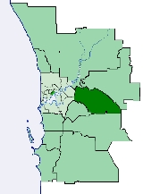
The Shire of Kalamunda is a Local Government Area
in the eastern suburbs of the Western Australia
n capital city of Perth
, located about 25 kilometres (15.5 mi) east of Perth's central business district
. The Shire covers an area of 324.2 square kilometres (125.2 sq mi), much of which is state forest rising into the Darling Scarp
to the east. It has a population of 49,534 (2006), making it the most populous shire (as opposed to cities or towns) in Western Australia.
Local Government Areas of Western Australia
The Australian state of Western Australia is divided into 141 local government areas...
in the eastern suburbs of the Western Australia
Western Australia
Western Australia is a state of Australia, occupying the entire western third of the Australian continent. It is bounded by the Indian Ocean to the north and west, the Great Australian Bight and Indian Ocean to the south, the Northern Territory to the north-east and South Australia to the south-east...
n capital city of Perth
Perth, Western Australia
Perth is the capital and largest city of the Australian state of Western Australia and the fourth most populous city in Australia. The Perth metropolitan area has an estimated population of almost 1,700,000....
, located about 25 kilometres (15.5 mi) east of Perth's central business district
Central business district
A central business district is the commercial and often geographic heart of a city. In North America this part of a city is commonly referred to as "downtown" or "city center"...
. The Shire covers an area of 324.2 square kilometres (125.2 sq mi), much of which is state forest rising into the Darling Scarp
Darling Scarp
The Darling Scarp, also referred to as the Darling Range or Darling Ranges, is a low escarpment running north-south to the east of the Swan Coastal Plain and Perth, Western Australia...
to the east. It has a population of 49,534 (2006), making it the most populous shire (as opposed to cities or towns) in Western Australia.
History
The Darling Range Road District was gazetted in 1897. On 1 July 1961, it became the Shire of Kalamunda after the enactment of the Local Government Act 1960.Wards
The shire has been divided into 5 wards.- East Ward (1 councillor)
- North Ward (3 councillors)
- North West Ward (2 councillors)
- South Ward (3 councillors)
- South West Ward (3 councillors)
Suburbs
- Bickley
- Canning MillsCanning Mills, Western AustraliaCanning Mills is a suburb of Perth, Western Australia, located within the Shire of Kalamunda. Canning Mills is a suburb of Perth, Western Australia, located within the Shire of Kalamunda. Canning Mills is a suburb of Perth, Western Australia, located within the Shire of Kalamunda. (incorrect!...
- CarmelCarmel, Western AustraliaCarmel is a suburb of Perth, Western Australia, located within the Shire of Kalamunda.Prior to 1949 it was a stopping place on the Upper Darling Range Railway. The railway siding was originally known as Green's Landing after Perth businessman Levi Green, who had moved into the area in 1844...
- ForrestfieldForrestfield, Western AustraliaForrestfield is a suburb of the Shire of Kalamunda in Western Australia. It lies 15 km to the southeast of Perth at the base of the Darling Scarp and the Southern border of the International Airport. There is authority to suggest it is named after Western Australia's first premier, John Forrest...
- Gooseberry HillGooseberry Hill, Western AustraliaGooseberry Hill is a suburb of Perth, Western Australia, located within the Shire of Kalamunda. It is the site of Gooseberry Hill National Park....
- Hacketts Gully
- High WycombeHigh Wycombe, Western AustraliaHigh Wycombe is a suburb of Perth, Western Australia, located within the Shire of Kalamunda. High Wycombe lies east of the Perth CBD at the base of the Darling Scarp ....
- KalamundaKalamunda, Western Australia-Transport:Kalamunda Road serves as a major access road for Perth Airport, and provides the foothills suburbs with access to the Perth central business district....
- LesmurdieLesmurdie, Western AustraliaLesmurdie is a suburb of Perth, Western Australia, located within the Shire of Kalamunda.It is viewed as being a rival suburb to the neighbouring suburb of Kalamunda directly to the north. The main access to the suburb from the Swan Coastal Plain is via Welshpool Road, that snakes its way up the...
- Maida ValeMaida Vale, Western AustraliaMaida Vale is a suburb of Perth, Western Australia, located within the Shire of Kalamunda. Kalamunda Road runs through the suburb.Within the suburb there is a primary school , a golf course, numerous parks/ovals , small shops including a BP Petrol station and a heated swimming pool...
- Paulls ValleyPaulls Valley, Western AustraliaPaulls Valley is a suburb of Perth, Western Australia, located within the Shire of Kalamunda. It was officially named in 1973 and commemorates an early orchardist in the district....
- Pickering BrookPickering Brook, Western AustraliaPickering Brook is a suburb of Perth, Western Australia, located within the Shire of Kalamunda.Prior to 1949 it was a stopping place on the Upper Darling Range Railway....
- Piesse BrookPiesse Brook, Western AustraliaPiesse Brook is a suburb of Perth, Western Australia, located within the Shire of Kalamunda. It was officially named in 1972, although the name had been in use since 1890 for a watercourse in the area which itself honoured William Roper Piesse, a prominent citizen with a large family who were at...
- ReservoirReservoir, Western AustraliaReservoir is a non-residential suburb of Perth, Western Australia, and is located within the Shire of Kalamunda....
- WallistonWalliston, Western AustraliaWalliston is a suburb of Perth, Western Australia, located within the Shire of Kalamunda.Prior to 1949 it was a stopping place on the Upper Darling Range Railway. It was named after John and Emma Wallis, the area's first settlers who arrived in the 1880s...
- Wattle GroveWattle Grove, Western AustraliaWattle Grove is a suburb of Perth, Western Australia, located within the Shire of Kalamunda.-Description:Wattle Grove is approximately 3/4 Semi Rural, and 1/4 Urban Development...
Population
| Year | Population |
|---|---|
| 1911 | 1,038 |
| 1921 | 1,751 |
| 1933 | 2,814 |
| 1947 | 4,113 |
| 1954 | 6,354 |
| 1961 | 7,524 |
| 1966 | 9,785 |
| 1971 | 18,362 |
| 1976 | 26,448 |
| 1981 | 35,475 |
| 1986 | 40,547 |
| 1991 | 45,733 |
| 1996 | 46,115 |
| 2001 | 46,059 |
| 2006 | 49,534 |