
Shire of Bruce Rock
Encyclopedia
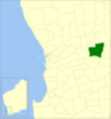
The Shire of Bruce Rock is a Local Government Area
in the Wheatbelt region of Western Australia
, about 50 kilometres (31 mi) south of Merredin
and about 250 kilometres (155 mi) east of the state capital, Perth
. The Shire covers an area of 2727 square kilometres (1,053 sq mi), and its seat of government is the town of Bruce Rock
.
Local Government Areas of Western Australia
The Australian state of Western Australia is divided into 141 local government areas...
in the Wheatbelt region of Western Australia
Western Australia
Western Australia is a state of Australia, occupying the entire western third of the Australian continent. It is bounded by the Indian Ocean to the north and west, the Great Australian Bight and Indian Ocean to the south, the Northern Territory to the north-east and South Australia to the south-east...
, about 50 kilometres (31 mi) south of Merredin
Merredin, Western Australia
-Economy:The agricultural land around Merredin produces 40% of Western Australia’s wheat quota. As a focal point for the region, Merredin’s local bulk handling co-operative receives and processes in excess of a million tonnes of grain every year...
and about 250 kilometres (155 mi) east of the state capital, Perth
Perth, Western Australia
Perth is the capital and largest city of the Australian state of Western Australia and the fourth most populous city in Australia. The Perth metropolitan area has an estimated population of almost 1,700,000....
. The Shire covers an area of 2727 square kilometres (1,053 sq mi), and its seat of government is the town of Bruce Rock
Bruce Rock, Western Australia
Bruce Rock is a town located in the Eastern Wheatbelt region of Western Australia, approximately east of Perth and southwest of Merredin. It is the main town in the Shire of Bruce Rock....
.
History
Bruce Rock was initially constituted as the East Avon Road Board in 1913. In 1918, it was renamed to Bruce Rock, and on 1 July 1961, it became a Shire following the enactment of the Local Government Act 1960. In 1999, the Ardath, Babakin, Kwolyin, Shackleton, Belka and Coordarin wards covering outlying areas of the Shire were replaced by 2-member South, West and East Wards, while the Central and Town wards covered other areas. Wards were abolished for the 2005 elections.Wards
The Shire is no longer divided into wards and the 11 councillors represent the entire Shire.Towns and localities
- Bruce RockBruce Rock, Western AustraliaBruce Rock is a town located in the Eastern Wheatbelt region of Western Australia, approximately east of Perth and southwest of Merredin. It is the main town in the Shire of Bruce Rock....
- ArdathArdath, Western AustraliaArdath is a small town located in the Wheatbelt region of Western Australia south of the town of Bruce Rock.It was built to serve the Corrigin to Bruce Rock railway, and originally named Kerkenin in April 1914...
- BabakinBabakin, Western AustraliaBabakin is a small town located in the Wheatbelt region of Western Australia between the towns of Bruce Rock and Corrigin. It has a population of approximately 25 people, and provides the local farming community with a school, shop, hall and sporting facilities.Babakin was a pastoral lease from...
- BelkaBelka, Western AustraliaBelka is a small town located in the Wheatbelt region of Western Australia between the towns of Bruce Rock and Merredin.The town originated as a station along the railway line for both passengers and heavy goods which was gazetted in 1914. The word is Aboriginal in origin and is thought to mean...
- ErikinErikin, Western AustraliaErikin is a small town located in the Eastern Wheatbelt region of Western Australia. It is loacted close to the Salt River and between the towns of Quairading and Bruce Rock....
- KwolyinKwolyin, Western AustraliaKwolyin is a small town in the Wheatbelt region of Western Australia.The first European to visit the area, in 1864, was the explorer Charles Cooke Hunt, who charted a large granite hill in the area by its Indigenous Australian name of Qualyin Hill...
- ShackletonShackleton, Western AustraliaShackleton in a small town in the Wheatbelt region of Western Australia.The town is located close to the Salt River and along the railway line between Bruce Rock and Quairading....
- Yarding
Population
| Year | Population |
|---|---|
| 1921 | 2,431 |
| 1933 | 2,498 |
| 1947 | 1,897 |
| 1954 | 2,384 |
| 1961 | 2,291 |
| 1966 | 2,142 |
| 1971 | 1,694 |
| 1976 | 1,470 |
| 1981 | 1,410 |
| 1986 | 1,298 |
| 1991 | 1,164 |
| 1996 | 1,126 |
| 2001 | 1,051 |
| 2006 | 950 |