

Shimokita District, Aomori
Encyclopedia
Districts of Japan
The was most recently used as an administrative unit in Japan between 1878 and 1921 and is roughly equivalent to the county of the United States, ranking at the level below prefecture and above city, town or village. As of 2008, cities belong directly to prefectures and are independent from...
located in Aomori Prefecture
Aomori Prefecture
is a prefecture of Japan located in the Tōhoku Region. The capital is the city of Aomori.- History :Until the Meiji Restoration, the area of Aomori prefecture was known as Mutsu Province....
, Japan
Japan
Japan is an island nation in East Asia. Located in the Pacific Ocean, it lies to the east of the Sea of Japan, China, North Korea, South Korea and Russia, stretching from the Sea of Okhotsk in the north to the East China Sea and Taiwan in the south...
. It occupies most of the northern handle of Shimokita Peninsula
Shimokita Peninsula
The Shimokita Peninsula is the remote northeastern cape of the Japanese island of Honshū, stretching out towards Hokkaidō. Administratively the area is a part of Aomori Prefecture....
with the exception of Mutsu City
Mutsu, Aomori
is a city located in northeastern Aomori in the Tōhoku region of Japan. As of 2009, the city had an estimated population of 61,205 and a density of 70.09 persons per km²...
and contains the most northern point on the island of Honshū
Honshu
is the largest island of Japan. The nation's main island, it is south of Hokkaido across the Tsugaru Strait, north of Shikoku across the Inland Sea, and northeast of Kyushu across the Kanmon Strait...
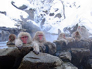
. It is also home to the Japanese macaque
Japanese Macaque
The Japanese macaque , historically known as saru , but now known as Nihonzaru to distinguish it from other primates, is a terrestrial Old World monkey species native to Japan....
, making it the northernmost natural habitat for monkeys anywhere in the world.
As of 2009, the district has an estimated population
Population
A population is all the organisms that both belong to the same group or species and live in the same geographical area. The area that is used to define a sexual population is such that inter-breeding is possible between any pair within the area and more probable than cross-breeding with individuals...
of 18,297 and a density
Population density
Population density is a measurement of population per unit area or unit volume. It is frequently applied to living organisms, and particularly to humans...
of 33.2 persons per km². The total area was 551. 08 km².
Towns and villages
The district currently consists of one town and three villages. The city of MutsuMutsu, Aomori
is a city located in northeastern Aomori in the Tōhoku region of Japan. As of 2009, the city had an estimated population of 61,205 and a density of 70.09 persons per km²...
was formerly part of the district.
- HigashidōriHigashidori, Aomoriis a village located in northeastern Aomori Prefecture in the Tōhoku region of Japan. As of 2009, the village had an estimated population of 7,544 and a density of 25.6 persons per km²...
- KazamauraKazamaura, Aomoriis a village located in Shimokita District, Aomori Prefecture, Japan.As of September 1, 2009, the village had an estimated population of 2,311 and a density of 33.2 persons per km²...
- ŌmaOma, Aomoriis a town located in northeastern Aomori in Tōhoku region of Japan. As of 2009, the town had an estimated population of 5,950 and a density of 114 persons per km². Its total area was 52.06 km².-Geography:...
- SaiSai, Aomoriis a village located in the Shimokita District of northeastern Aomori Prefecture in the Tōhoku region of Japan. As of 2009, the village had an estimated population of 2,492 and a density of 18.5 persons per km². Its total area was 135.03 km².-Geography:...
History
Shimokita District was part of ancient , established by the Northern FujiwaraNorthern Fujiwara
The Northern Fujiwara were a Japanese noble family that ruled the Tōhoku region of Japan from the 12th to the 13th centuries as if it were their own realm. They succeeded the semi-independent Emishi families of the 11th century who were gradually brought down by the Minamoto clan loyal to the...
. During the Edo period
Edo period
The , or , is a division of Japanese history which was ruled by the shoguns of the Tokugawa family, running from 1603 to 1868. The political entity of this period was the Tokugawa shogunate....
, the area was part of the Morioka han
Morioka Domain
The was a han or feudal domain that encompasses present-day the middle-northern part of Iwate Prefecture and eastern part of Aomori Prefecture. It is sometimes colloquially called . The domain was tozama daimyo and was governed by the Satake clan. Its income was 100,000...
feudal domain
Han (Japan)
The or domain was the name of the estate belonging to a warrior in Japan after the 17th century. The fiefs of the daimyos of the samurai class of Japan during the Edo period were called han.-Edo period:...
of the Nambu clan, with a daikansho
Daikansho
A was the office of a magistrate during the Edo period of Japanese history.-External links:* *...
located in Tanabu (now part of the city of Mutsu
Mutsu, Aomori
is a city located in northeastern Aomori in the Tōhoku region of Japan. As of 2009, the city had an estimated population of 61,205 and a density of 70.09 persons per km²...
.
The Nambu clan sided with the Ōuetsu Reppan Dōmei
Ouetsu Reppan Domei
-External links:**...
during the Boshin War
Boshin War
The was a civil war in Japan, fought from 1868 to 1869 between forces of the ruling Tokugawa shogunate and those seeking to return political power to the imperial court....
of the Meiji Restoration
Meiji Restoration
The , also known as the Meiji Ishin, Revolution, Reform or Renewal, was a chain of events that restored imperial rule to Japan in 1868...
and were punished by the new Meiji government by loss of their northern territories. In November 1869, Kita-gun and neighboring Sannohe District
Sannohe District, Aomori
is a district located in Aomori Prefecture, Japan. It occupies the southeast corner of the prefecture, bordering Iwate Prefecture.As of 2010, the district has an estimated population of 73,955 and a density of 76.3 persons per km². The total area was 969.38 km².- Towns and villages :The...
became part of the newly created , a 30,000 koku
Koku
The is a Japanese unit of volume, equal to ten cubic shaku. In this definition, 3.5937 koku equal one cubic metre, i.e. 1 koku is approximately 278.3 litres. The koku was originally defined as a quantity of rice, historically defined as enough rice to feed one person for one year...
holding created to resettle the dispossessed Matsudaira clan
Matsudaira clan
The was a Japanese samurai clan that claimed descent from the Minamoto clan. It first originated in and took its name from Matsudaira village, in Mikawa Province . Over the course of its history, the clan produced many branches, most of which also centered around Mikawa Province...
from Aizu-Wakamatsu. In July 1871, with the abolition of the han system
Abolition of the han system
The was an act, in 1871, of the new Meiji government of the Empire of Japan to replace the traditional feudal domain system and to introduce centralized government authority . This process marked the culmination of the Meiji Restoration in that all daimyo were required to return their authority...
, Tonami Domain became Tonami Prefecture, and was merged into the newly-created Aomori Prefecture in September 1871.
During the early Meiji period
Meiji period
The , also known as the Meiji era, is a Japanese era which extended from September 1868 through July 1912. This period represents the first half of the Empire of Japan.- Meiji Restoration and the emperor :...
administrative reorganization of Japan on July 22, 1878, Shimokita and Kamikita
Kamikita District, Aomori
is a district located in Aomori Prefecture, Japan. It occupies the east-central portion of the prefecture, south of Shimokita Peninsula.As of 2010, the district has an estimated population of 100,526 and a density of 78.5 persons per km². The total area was 1281.05 km².- Towns and villages...
were divided from former Kita County, and Shimokita was divided into 33 villages. In the cadastral reform of April 1, 1889, the number of villages was reduced through consolidations and mergers to nine. Tanabu Village was elevated to town status on January 1, 1899 and Kawauchi Village became Kawauchi Town
Kawauchi, Aomori
was a town located in Shimokita District in northern Aomori Prefecture, Japan.Kawauchi Village was founded in 1889 from the merger the hamlets of Kawauchi, Hinokigawa, Shukunohe, and Kakizaki. It was elevated to town status on October 31, 1917...
on October 31, 1917. On November 10, 1928 the Imperial Japanese Navy
Imperial Japanese Navy
The Imperial Japanese Navy was the navy of the Empire of Japan from 1869 until 1947, when it was dissolved following Japan's constitutional renunciation of the use of force as a means of settling international disputes...
port of Ōminato was proclaimed a town, followed by Ōhata Town
Ohata, Aomori
was a town located in Shimokita District in northern Aomori Prefecture, Japan.Ōhata Village was founded in 1889. It was elevated to town status on May 1, 1934...
on May 1, 1934. Ōma Village became Ōma Town on November 3, 1942. On September 1, 1959 Ōminato and Tanabu towns merged to form the city of Ōminato-Tanabu, later renamed Mutsu. On March 14, 2005 the towns of Kawauchi and Ōhata and the village of Wakinosawa
Wakinosawa, Aomori
was a village located in Shimokita District in northern Aomori Prefecture, Japan.Wakinosawa Village was founded in 1889 from the merger the hamlets of Wakinosawa with neighboring Ozawa...
merged into the city of Mutsu
Mutsu, Aomori
is a city located in northeastern Aomori in the Tōhoku region of Japan. As of 2009, the city had an estimated population of 61,205 and a density of 70.09 persons per km²...
.
| pre-1889 | April 1, 1889 | 1889 - 1949 | 1950–1989 | 1989–present | present | |
|---|---|---|---|---|---|---|
| Ōma Village・Okudo Village | Ōoku Village | November 3, 1942 Ōma Town |
Ōma Town | Ōma Town | Ōma Oma, Aomori is a town located in northeastern Aomori in Tōhoku region of Japan. As of 2009, the town had an estimated population of 5,950 and a density of 114 persons per km². Its total area was 52.06 km².-Geography:... |
|
| Shimofuro Village・Ikokuma Village Hebiurakani Village |
Kazamaura Village | Kazamaura Village | Kazamaura Village | Kazamaura Village | Kazamaura Kazamaura, Aomori is a village located in Shimokita District, Aomori Prefecture, Japan.As of September 1, 2009, the village had an estimated population of 2,311 and a density of 33.2 persons per km²... |
|
| Sai Village・Chogo Village | Sai Village | Sai Village | Sai Village | Sai Village | Sai Sai, Aomori is a village located in the Shimokita District of northeastern Aomori Prefecture in the Tōhoku region of Japan. As of 2009, the village had an estimated population of 2,492 and a density of 18.5 persons per km². Its total area was 135.03 km².-Geography:... |
|
| Tanabu Village・Sekine Village Okunai Village・Nakanosawa Village |
Tanabu Village | January 1, 1901 Tanabu Town |
September 1, 1959 Ōminato-Tanabu City |
August 1, 1960 name change Mutsu City |
Mutsu City | Mutsu Mutsu, Aomori is a city located in northeastern Aomori in the Tōhoku region of Japan. As of 2009, the city had an estimated population of 61,205 and a density of 70.09 persons per km²... |
| Ōminato Village・Ōhira Village Jogasawa Village |
Ōminato Village | November 10, 1928 Ōminato Town |
||||
| Kawauchi Village・Hikawa Village Shukuobe Village・Kakizaki Village |
Kawauchi Village | October 31, 1917 Kawauchi Town |
Kawauchi Town | March 14, 2005 merged with Mutsu City |
||
| Ōhata Village・Shozugawa Village | Ōhata Village | May 1, 1934 Ōhata Town |
Ōhata Town | |||
| Wakinosawa Village・Ozawa Village | Wakinosawa Village | Wakinosawa Village | Wakinosawa Village | |||
| Ōri Village・Mena Village Gamanosawa Village・Noushi Village Iwaya Village・Shikariya Village Shitsukari Village・Sarugamori Village Odanozawa Village・Shiranuka Village Sunagomata Village・Taya Village |
Higashidōri Village | Higashidōri Village | Higashidōri Village | Higashidōri Village | Higashidōri Higashidori, Aomori is a village located in northeastern Aomori Prefecture in the Tōhoku region of Japan. As of 2009, the village had an estimated population of 7,544 and a density of 25.6 persons per km²... |
|