
Shelburne Falls, Massachusetts
Encyclopedia
Shelburne Falls is a census-designated place
(CDP) in the towns of Shelburne
and Buckland
in Franklin County
, Massachusetts
, United States
. The population was 1,951 at the 2000 census. It is part of the Springfield, Massachusetts
, Metropolitan Statistical Area
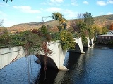
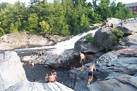
. Notable features include the Bridge of Flowers, a former trolley bridge over the Deerfield River
that is now maintained by the Shelburne Falls Women's Club as a floral display from April through October; and the glacial potholes of the Deerfield River. Bill and Camille Cosby
are well known and admired residents of the area, though they keep a relatively low profile. The downtown is alive and well, including an independently-owned pharmacy with a soda fountain, one coffeeshop, a trolley museum, several restaurants, two pizza parlours, three bookstores, a newsstand, a grocery store, a natural foods store, many artists' galleries, and the candlepin
Shelburne Falls Bowling Alley. A community newspaper, the West County Independent, serves Shelburne Falls and the surrounding towns. On the Shelburne side of town is the Buckland-Shelburne Elementary School, with over 200 students. On the Buckland side of town is Mohawk Trail Regional Middle School/High School with approximately 500 students.
 The Deerfield River
bisects Shelburne Falls, and Massaemett Mountain
rises east of the village.
According to the United States Census Bureau
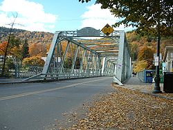
, the CDP has a total area of 6.8 km² (2.6 mi²). 6.6 km² (2.5 mi²) of it is land and 0.3 km² (0.1 mi²) of it (3.79%) is water. Shelburne Falls is served by Route 2, also known as the Mohawk Trail
, as well as Routes 2A and 112, the latter being the main route through the village.
The residence of the famous Daniella Ruhf
 As of the census
of 2000, there were 1,951 people, 815 households, and 466 families residing in the CDP. The population density
was 296.6/km² (768.3/mi²). There were 878 housing units at an average density of 133.5/km² (345.8/mi²). The racial makeup of the CDP was 96.92% White, 0.26% African American, 0.67% Native American, 0.67% Asian, 0.05% Pacific Islander, 0.46% from other races
, and 0.97% from two or more races. Hispanic or Latino of any race were 0.82% of the population.
There were 815 households out of which 27.2% had children under the age of 18 living with them, 41.3% were married couples
living together, 12.4% had a female householder with no husband present, and 42.7% were non-families. 34.0% of all households were made up of individuals and 15.2% had someone living alone who was 65 years of age or older. The average household size was 2.28 and the average family size was 2.94.
In the CDP the population was spread out with 21.8% under the age of 18, 8.8% from 18 to 24, 25.3% from 25 to 44, 25.1% from 45 to 64, and 19.0% who were 65 years of age or older. The median age was 41 years. For every 100 females there were 86.5 males. For every 100 females age 18 and over, there were 80.3 males.
The median income for a household in the CDP was $36,333, and the median income for a family was $41,250. Males had a median income of $32,403 versus $26,534 for females. The per capita income
for the CDP was $18,367. About 7.4% of families and 10.1% of the population were below the poverty line, including 9.5% of those under age 18 and 9.6% of those age 65 or over.
and Shelburne
inked a memorandum of agreement with officials from Mutianyu
, a village in China, making the two the first known "sister villages."
Census-designated place
A census-designated place is a concentration of population identified by the United States Census Bureau for statistical purposes. CDPs are delineated for each decennial census as the statistical counterparts of incorporated places such as cities, towns and villages...
(CDP) in the towns of Shelburne
Shelburne, Massachusetts
Shelburne is a town in Franklin County, Massachusetts, United States. The population was 2,058 at the 2000 census. It is part of the Springfield, Massachusetts Metropolitan Statistical Area.The village of Shelburne Falls is located in the town.- History :...
and Buckland
Buckland, Massachusetts
Buckland is a town in Franklin County, Massachusetts, United States. The population was 1,991 at the 2000 census. The town shares the village of Shelburne Falls with neighboring Shelburne...
in Franklin County
Franklin County, Massachusetts
-Demographics:As of the census of 2000, there were 71,535 people, 29,466 households, and 18,416 families residing in the county. The population density was 102 people per square mile . There were 31,939 housing units at an average density of 46 per square mile...
, Massachusetts
Massachusetts
The Commonwealth of Massachusetts is a state in the New England region of the northeastern United States of America. It is bordered by Rhode Island and Connecticut to the south, New York to the west, and Vermont and New Hampshire to the north; at its east lies the Atlantic Ocean. As of the 2010...
, United States
United States
The United States of America is a federal constitutional republic comprising fifty states and a federal district...
. The population was 1,951 at the 2000 census. It is part of the Springfield, Massachusetts
Springfield, Massachusetts
Springfield is the most populous city in Western New England, and the seat of Hampden County, Massachusetts, United States. Springfield sits on the eastern bank of the Connecticut River near its confluence with three rivers; the western Westfield River, the eastern Chicopee River, and the eastern...
, Metropolitan Statistical Area
Springfield, Massachusetts metropolitan area
The Springfield Metropolitan Area is a region that is socio-economically and culturally tied to the City of Springfield, Massachusetts. The U.S. Office of Management and Budget defines the Springfield metropolitan statistical area as consisting of three counties in Western Massachusetts. As of...
. Notable features include the Bridge of Flowers, a former trolley bridge over the Deerfield River
Deerfield River
Deerfield River is a river that runs for from southern Vermont through northwestern Massachusetts to the Connecticut River. The Deerfield was historically influential in the settlement of western Franklin County, Massachusetts, and its namesake town...
that is now maintained by the Shelburne Falls Women's Club as a floral display from April through October; and the glacial potholes of the Deerfield River. Bill and Camille Cosby
Bill Cosby
William Henry "Bill" Cosby, Jr. is an American comedian, actor, author, television producer, educator, musician and activist. A veteran stand-up performer, he got his start at various clubs, then landed a starring role in the 1960s action show, I Spy. He later starred in his own series, the...
are well known and admired residents of the area, though they keep a relatively low profile. The downtown is alive and well, including an independently-owned pharmacy with a soda fountain, one coffeeshop, a trolley museum, several restaurants, two pizza parlours, three bookstores, a newsstand, a grocery store, a natural foods store, many artists' galleries, and the candlepin
Candlepin bowling
Candlepin bowling is a variation of Bowling that is played primarily in the Canadian Maritime provinces, Ontario, Quebec, and the New England states of Maine, Massachusetts and New Hampshire, where it is more common than ten-pin bowling....
Shelburne Falls Bowling Alley. A community newspaper, the West County Independent, serves Shelburne Falls and the surrounding towns. On the Shelburne side of town is the Buckland-Shelburne Elementary School, with over 200 students. On the Buckland side of town is Mohawk Trail Regional Middle School/High School with approximately 500 students.
Geography
Deerfield River
Deerfield River is a river that runs for from southern Vermont through northwestern Massachusetts to the Connecticut River. The Deerfield was historically influential in the settlement of western Franklin County, Massachusetts, and its namesake town...
bisects Shelburne Falls, and Massaemett Mountain
Massaemett Mountain
Massaemett Mountain is a mountain in Shelburne, Massachusetts, USA. It is located east of the village of Shelburne Falls.The summit features a historic rock fire tower...
rises east of the village.
According to the United States Census Bureau
United States Census Bureau
The United States Census Bureau is the government agency that is responsible for the United States Census. It also gathers other national demographic and economic data...
, the CDP has a total area of 6.8 km² (2.6 mi²). 6.6 km² (2.5 mi²) of it is land and 0.3 km² (0.1 mi²) of it (3.79%) is water. Shelburne Falls is served by Route 2, also known as the Mohawk Trail
Mohawk Trail
- External links :* *...
, as well as Routes 2A and 112, the latter being the main route through the village.
The residence of the famous Daniella Ruhf
Demographics
Census
A census is the procedure of systematically acquiring and recording information about the members of a given population. It is a regularly occurring and official count of a particular population. The term is used mostly in connection with national population and housing censuses; other common...
of 2000, there were 1,951 people, 815 households, and 466 families residing in the CDP. The population density
Population density
Population density is a measurement of population per unit area or unit volume. It is frequently applied to living organisms, and particularly to humans...
was 296.6/km² (768.3/mi²). There were 878 housing units at an average density of 133.5/km² (345.8/mi²). The racial makeup of the CDP was 96.92% White, 0.26% African American, 0.67% Native American, 0.67% Asian, 0.05% Pacific Islander, 0.46% from other races
Race (United States Census)
Race and ethnicity in the United States Census, as defined by the Federal Office of Management and Budget and the United States Census Bureau, are self-identification data items in which residents choose the race or races with which they most closely identify, and indicate whether or not they are...
, and 0.97% from two or more races. Hispanic or Latino of any race were 0.82% of the population.
There were 815 households out of which 27.2% had children under the age of 18 living with them, 41.3% were married couples
Marriage
Marriage is a social union or legal contract between people that creates kinship. It is an institution in which interpersonal relationships, usually intimate and sexual, are acknowledged in a variety of ways, depending on the culture or subculture in which it is found...
living together, 12.4% had a female householder with no husband present, and 42.7% were non-families. 34.0% of all households were made up of individuals and 15.2% had someone living alone who was 65 years of age or older. The average household size was 2.28 and the average family size was 2.94.
In the CDP the population was spread out with 21.8% under the age of 18, 8.8% from 18 to 24, 25.3% from 25 to 44, 25.1% from 45 to 64, and 19.0% who were 65 years of age or older. The median age was 41 years. For every 100 females there were 86.5 males. For every 100 females age 18 and over, there were 80.3 males.
The median income for a household in the CDP was $36,333, and the median income for a family was $41,250. Males had a median income of $32,403 versus $26,534 for females. The per capita income
Per capita income
Per capita income or income per person is a measure of mean income within an economic aggregate, such as a country or city. It is calculated by taking a measure of all sources of income in the aggregate and dividing it by the total population...
for the CDP was $18,367. About 7.4% of families and 10.1% of the population were below the poverty line, including 9.5% of those under age 18 and 9.6% of those age 65 or over.
Sister cities
In May 2007, selectmen from the towns of BucklandBuckland, Massachusetts
Buckland is a town in Franklin County, Massachusetts, United States. The population was 1,991 at the 2000 census. The town shares the village of Shelburne Falls with neighboring Shelburne...
and Shelburne
Shelburne, Massachusetts
Shelburne is a town in Franklin County, Massachusetts, United States. The population was 2,058 at the 2000 census. It is part of the Springfield, Massachusetts Metropolitan Statistical Area.The village of Shelburne Falls is located in the town.- History :...
inked a memorandum of agreement with officials from Mutianyu
Mutianyu
Mutianyu is a section of the Great Wall of China located in Huairou County 70km northeast of Beijing. The Mutianyu section of the Great Wall is connected with Jiankou in the west and Lianhuachi in the east...
, a village in China, making the two the first known "sister villages."
See also
- Shelburne Falls Trolley MuseumShelburne Falls Trolley MuseumThe Shelburne Falls Trolley Museum is a small railroad museum in Shelburne Falls, Massachusetts, United States.The museum is dedicated to preserving and operating car number 10 of the former Shelburne Falls and Colrain Street Railway...