
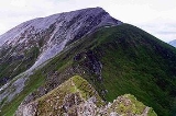
Sgurr a' Mhàim
Encyclopedia
Scotland
Scotland is a country that is part of the United Kingdom. Occupying the northern third of the island of Great Britain, it shares a border with England to the south and is bounded by the North Sea to the east, the Atlantic Ocean to the north and west, and the North Channel and Irish Sea to the...
mountain
Mountain
Image:Himalaya_annotated.jpg|thumb|right|The Himalayan mountain range with Mount Everestrect 58 14 160 49 Chomo Lonzorect 200 28 335 52 Makalurect 378 24 566 45 Mount Everestrect 188 581 920 656 Tibetan Plateaurect 250 406 340 427 Rong River...
situated five and a half kilometres north north-west of Kinlochleven
Kinlochleven
Kinlochleven is a village in Lochaber, in the Scottish Highlands and lies at the eastern end of Loch Leven, a sea loch cutting into the western Scottish Highlands. To the north lie the Mamores ridge; to the south lie the mountains flanking Glen Coe...
in the Lochaber
Lochaber
District of Lochaber 1975 to 1996Highland council area shown as one of the council areas of ScotlandLochaber is one of the 16 ward management areas of the Highland Council of Scotland and one of eight former local government districts of the two-tier Highland region...
region of the Highland
Highland (council area)
Highland is a council area in the Scottish Highlands and is the largest local government area in both Scotland and the United Kingdom as a whole. It shares borders with the council areas of Moray, Aberdeenshire, Perth and Kinross, and Argyll and Bute. Their councils, and those of Angus and...
area.
Overview
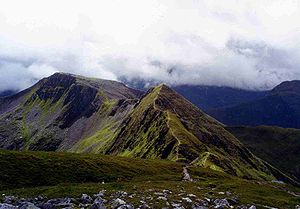
With a height of 1099 metres (3605 feet) Sgurr a’ Mhàim is a MunroMunro
A Munro is a mountain in Scotland with a height over . They are named after Sir Hugh Munro, 4th Baronet , who produced the first list of such hills, known as Munros Tables, in 1891. A Munro top is a summit over 3,000 ft which is not regarded as a separate mountain...
and the second highest peak in the Mamores
Mamores
The Mamores are a group of mountains in the Lochaber area of the Grampian Mountains in the Scottish Highlands. They form an east-west ridge approximately fifteen kilometres in length lying between Glen Nevis to the north and Loch Leven to the south....
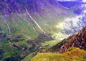
. It is a distinctive mountain being well seen up Glen Nevis
Glen Nevis
Glen Nevis is a glen in Lochaber, Highland, Scotland, with Fort William at its foot. It is bordered to the south by the Mamore range, and to the north by the highest mountains in the British Isles: Ben Nevis, Càrn Mor Dearg, Aonach Mòr, and Aonach Beag...
from Fort William with its capping of quartzite
Quartzite
Quartzite is a hard metamorphic rock which was originally sandstone. Sandstone is converted into quartzite through heating and pressure usually related to tectonic compression within orogenic belts. Pure quartzite is usually white to gray, though quartzites often occur in various shades of pink...
stones catching the eye and giving it a light grey appearance which can be mistaken for a covering of snow. Surprisingly its Gaelic
Scottish Gaelic language
Scottish Gaelic is a Celtic language native to Scotland. A member of the Goidelic branch of the Celtic languages, Scottish Gaelic, like Modern Irish and Manx, developed out of Middle Irish, and thus descends ultimately from Primitive Irish....
name gives no mention of these distinctive white rocks, being translated as "Peak of the large rounded hill". When viewed from Glen Nevis it looks like a great breast although the name can also be translated as "Peak of the Pass"
Geography
Sgurr a’ Mhàim is probably best known as the first or last peak of the “Ring of Steall”, a popular ridge walk taking in the other Munros of An GearanachAn Gearanach
An Gearanach is a Scottish mountain situated in the Mamore Forest, five and a half kilometres north of Kinlochleven in the Lochaber region of the Highland council area.- Overview :...
, Stob Coire a' Chàirn
Stob Coire a' Chàirn
Stob Coire a’ Chàirn is a Scottish mountain situated in the Mamores range, 3.5 kilometres north of Kinlochleven. The mountain reaches a height of 981 metres and is regarded as one of the more modest peaks of the ten Munros in the Mamores, indeed for many years it was not named on OS maps...
and Am Bodach
Am Bodach
Am Bodach is a Scottish mountain which lies in the Mamores range, four kilometres north of Kinlochleven in the Highland council area.- Overview :...
. It is linked to the main spine of the Mamore group on its southern side by its most striking feature, The Devil’s Ridge, which is a one kilometre undulating ridge with a few exposed sections which need care. The most difficult part is known as "The Bad Step" with well known Scottish hill walker Hamish Brown
Hamish Brown
Hamish Brown M.B.E. is a professional writer, lecturer and photographer specialising in mountain and outdoor topics. He is best known for his walking exploits in the Scottish Highlands, having completed multiple rounds of the Munros and being the first person to walk all the Munros in a single trip...
commenting,
The Devil's Ridge has its own peak at the mid point called Stob Choire a’ Mhàil (990 metres) and then carries on to link to Sgor an Iubhair (Peak of the Yew; sometimes spelt Sgùrr an Iubhair), a 1001 m peak that briefly gained Munro status in 1981 only to lose it again in 1997. When viewed from the ridge Sgor an Iubhair looks every inch a separate distinctive mountain (see picture below). Both the above peaks are listed as "tops" of Sgurr a’ Mhàim in the Munro Tables. Sgurr a’ Mhàim's northern side contrasts to its southern flank (where the Devil’s Ridge is). Caution is needed around the northern slopes as they drop steeply to Glen Nevis, here there are two fine corries
Cirque
Cirque may refer to:* Cirque, a geological formation* Makhtesh, an erosional landform found in the Negev desert of Israel and Sinai of Egypt*Cirque , an album by Biosphere* Cirque Corporation, a company that makes touchpads...
which end abruptly in cliffs which fall steeply into the Nevis gorge.
Ascents
Despite the difficulties on the northern flank, it is from that side that the mountain can be ascended directly using one of the three ridges that are thrown down to the glen. The most popular of these is up the north west ridge from Achriabhach (grid reference ) where there is a car park but it is also possible to ascend from upper Glen Nevis via the north east or east ridges which spring from the Allt Coire a’ Mhàil above the An Steall Ban waterfall, both these routes require some scrambling. Any visit to Sgurr a’ Mhàim should include a crossing of the Devil's Ridge and a more circuitous ascent goes up to the head of Coire a' Mhusgain from Achriabhach to cross the ridge to the summit. The summit cairn is substantial being made up of light coloured quartzite stones and gives a very good view of the southern side of Ben NevisBen Nevis
Ben Nevis is the highest mountain in the British Isles. It is located at the western end of the Grampian Mountains in the Lochaber area of the Scottish Highlands, close to the town of Fort William....
and also an aerial view down into Glen Nevis.