
Seymour, Tennessee
Encyclopedia
Seymour is an unincorporated
community and a census-designated place
(CDP) in Blount
and Sevier
counties in the U.S. state
of Tennessee
, United States
. The CDP population was 8,850 at the 2000 U.S. census. It is included in the Knoxville, Tennessee
Metropolitan Statistical Area.
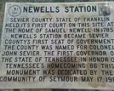
 Seymour was originally the site of Newell's Station, a frontier station established by early Sevier County pioneer Samuel Newell (1754–1841) in 1783. The first court of Sevier County, State of Franklin
, was held at Newell's Station in March 1785. During the 19th century, the community was known as Trundles Crossroads, where the main road from Sevierville forked, with one branch continuing northward to Knoxville and one branch westward to Maryville (now the intersection of Boyds Creek Highway and Old Sevierville Pike).
Upon completion on December 18, 1909, of the Knoxville, Sevierville & Eastern Railway, the community's station was named Seymour in honor of the line's chief engineer. The Trundles Crossroads Post Office changed its name soon after to reflect the community's new designation.
. Bluff Mountain, the northern terminus of the Chilhowee Mountain
ridge, rises prominently to the south, while the Bays Mountain
ridge passes to the north.
According to the United States Census Bureau
, the CDP has a total area of 12.7 square miles (32.8 km²), of which, 12.6 square miles (32.7 km²) of it is land and 0.04 square miles (0.1 km²) of it (0.16%) is water.
Chapman Highway (part of U.S. Route 441
) traverses Seymour, connecting the community with Knoxville
to the north. Near the center of Seymour, Chapman Highway forms a four-way intersection with U.S. Route 411
, which approaches from Maryville
to the west, and Boyds Creek Highway (State Route 338), which approaches from Boyds Creek
to the east. At this intersection, Chapman Highway merges with US-411, and continues southeastward to Sevierville
.
of 2000, there were 8,850 people, 3,431 households, and 2,669 families residing in the CDP. The population density
was 700.0 people per square mile (270.3/km²). There were 3,624 housing units at an average density of 286.6/sq mi (110.7/km²). The racial makeup of the CDP was 97.95% White, 0.36% African American, 0.16% Native American, 0.47% Asian, 0.23% from other races
, and 0.82% from two or more races. Hispanic or Latino of any race were 0.87% of the population.
There were 3,431 households out of which 33.5% had children under the age of 18 living with them, 66.2% were married couples
living together, 8.9% had a female householder with no husband present, and 22.2% were non-families. 19.0% of all households were made up of individuals and 6.2% had someone living alone who was 65 years of age or older. The average household size was 2.57 and the average family size was 2.93.
In the CDP the population was spread out with 24.3% under the age of 18, 7.8% from 18 to 24, 29.5% from 25 to 44, 26.6% from 45 to 64, and 11.8% who were 65 years of age or older. The median age was 38 years. For every 100 females there were 95.4 males. For every 100 females age 18 and over, there were 91.3 males.
The median income for a household in the CDP was $40,896, and the median income for a family was $45,244. Males had a median income of $30,568 versus $24,611 for females. The per capita income
for the CDP was $18,064. About 3.2% of families and 4.2% of the population were below the poverty line, including 3.5% of those under age 18 and 5.7% of those age 65 or over.
The Seymour Chamber of Commerce contends that the CDP does not include the entire area that is identified as the Seymour community, which the Chamber estimates to have had a total population of about 13,500 people in 2000
Unincorporated area
In law, an unincorporated area is a region of land that is not a part of any municipality.To "incorporate" in this context means to form a municipal corporation, a city, town, or village with its own government. An unincorporated community is usually not subject to or taxed by a municipal government...
community and a census-designated place
Census-designated place
A census-designated place is a concentration of population identified by the United States Census Bureau for statistical purposes. CDPs are delineated for each decennial census as the statistical counterparts of incorporated places such as cities, towns and villages...
(CDP) in Blount
Blount County, Tennessee
Blount County is a U.S. county located in the U.S. state of Tennessee. Its population was 123,010 at the United States Census, 2010. The county seat is at Maryville, which is also the county's largest city....
and Sevier
Sevier County, Tennessee
Sevier County is a county of the state of Tennessee, United States. Its population was 71,170 at the 2000 United States Census. It is included in the Sevierville, Tennessee, Micropolitan Statistical Area, which is included in the Knoxville-Sevierville-La Follette, TN Combined Statistical Area. The...
counties in the U.S. state
U.S. state
A U.S. state is any one of the 50 federated states of the United States of America that share sovereignty with the federal government. Because of this shared sovereignty, an American is a citizen both of the federal entity and of his or her state of domicile. Four states use the official title of...
of Tennessee
Tennessee
Tennessee is a U.S. state located in the Southeastern United States. It has a population of 6,346,105, making it the nation's 17th-largest state by population, and covers , making it the 36th-largest by total land area...
, United States
United States
The United States of America is a federal constitutional republic comprising fifty states and a federal district...
. The CDP population was 8,850 at the 2000 U.S. census. It is included in the Knoxville, Tennessee
Knoxville, Tennessee
Founded in 1786, Knoxville is the third-largest city in the U.S. state of Tennessee, U.S.A., behind Memphis and Nashville, and is the county seat of Knox County. It is the largest city in East Tennessee, and the second-largest city in the Appalachia region...
Metropolitan Statistical Area.
History
State of Franklin
The State of Franklin, known also as the Free Republic of Franklin or the State of Frankland , was an unrecognized autonomous United States territory created in 1784 from part of the territory west of the Appalachian Mountains that had been offered,...
, was held at Newell's Station in March 1785. During the 19th century, the community was known as Trundles Crossroads, where the main road from Sevierville forked, with one branch continuing northward to Knoxville and one branch westward to Maryville (now the intersection of Boyds Creek Highway and Old Sevierville Pike).
Upon completion on December 18, 1909, of the Knoxville, Sevierville & Eastern Railway, the community's station was named Seymour in honor of the line's chief engineer. The Trundles Crossroads Post Office changed its name soon after to reflect the community's new designation.
Geography
Seymour is located at 35°52′14"N 83°46′33"W (35.870533, -83.775936). The community is situated in a rolling valley where the Foothills of the Great Smoky Mountains give way to the Ridge-and-Valley AppalachiansRidge-and-valley Appalachians
The Ridge-and-Valley Appalachians, also called the Ridge and Valley Province or the Valley and Ridge Appalachians, are a physiographic province of the larger Appalachian division and are also a belt within the Appalachian Mountains extending from southeastern New York through northwestern New...
. Bluff Mountain, the northern terminus of the Chilhowee Mountain
Chilhowee Mountain
Chilhowee Mountain is a low ridge at the outer edge of the Great Smoky Mountains that stretches between the Little Tennessee River to the west and the Little Pigeon River watershed to the east...
ridge, rises prominently to the south, while the Bays Mountain
Bays Mountain
Bays Mountain is a ridge of the Ridge-and-Valley Appalachians, located in eastern Tennessee. It runs southwest to northeast, from just south of Knoxville to Kingsport.Its southern segment is relatively low in elevation...
ridge passes to the north.
According to the United States Census Bureau
United States Census Bureau
The United States Census Bureau is the government agency that is responsible for the United States Census. It also gathers other national demographic and economic data...
, the CDP has a total area of 12.7 square miles (32.8 km²), of which, 12.6 square miles (32.7 km²) of it is land and 0.04 square miles (0.1 km²) of it (0.16%) is water.
Chapman Highway (part of U.S. Route 441
U.S. Route 441
U.S. Route 441 is a spur route of U.S. Route 41. It currently runs for 939 miles from U.S. Route 41 in Miami, Florida to U.S. Route 25W in Lake City, Tennessee. Between its termini, US 441 passes through the states of Florida, Georgia, North Carolina, and Tennessee...
) traverses Seymour, connecting the community with Knoxville
Knoxville, Tennessee
Founded in 1786, Knoxville is the third-largest city in the U.S. state of Tennessee, U.S.A., behind Memphis and Nashville, and is the county seat of Knox County. It is the largest city in East Tennessee, and the second-largest city in the Appalachia region...
to the north. Near the center of Seymour, Chapman Highway forms a four-way intersection with U.S. Route 411
U.S. Route 411
U.S. Highway 411 is an alternate parallel-highway associated with U.S. Highway 11. U.S. 411 extends for about 313 miles from U.S. Route 78 in Leeds, Jefferson County, Alabama, to U.S. Highway 25 in Newport, Cocke County, Tennessee. U.S. 411 passes through the northeastern State of Alabama, the...
, which approaches from Maryville
Maryville, Tennessee
Maryville is the county seat of Blount County, Tennessee, in the Southeastern United States. The city is located south of Knoxville. Maryville's population was 27,258 at the 2010 census. It is included in the Knoxville Metropolitan Area. Maryville has received a number of accolades for its...
to the west, and Boyds Creek Highway (State Route 338), which approaches from Boyds Creek
Boyds Creek, Tennessee
Boyds Creek is an unincorporated community in Sevier County, Tennessee, United States. It is named for a small southward-flowing tributary of the French Broad River of the same name, which itself derives its name from a Virginian trader killed by a band of Cherokee Indians whose body was thrown...
to the east. At this intersection, Chapman Highway merges with US-411, and continues southeastward to Sevierville
Sevierville, Tennessee
Sevierville is a city in Sevier County, Tennessee, located in the Southeastern United States. Its population was 11,757 at the 2000 United States Census; in 2004 the estimated population was 14,101. Sevierville is the county seat of Sevier County, Tennessee....
.
Demographics
As of the censusCensus
A census is the procedure of systematically acquiring and recording information about the members of a given population. It is a regularly occurring and official count of a particular population. The term is used mostly in connection with national population and housing censuses; other common...
of 2000, there were 8,850 people, 3,431 households, and 2,669 families residing in the CDP. The population density
Population density
Population density is a measurement of population per unit area or unit volume. It is frequently applied to living organisms, and particularly to humans...
was 700.0 people per square mile (270.3/km²). There were 3,624 housing units at an average density of 286.6/sq mi (110.7/km²). The racial makeup of the CDP was 97.95% White, 0.36% African American, 0.16% Native American, 0.47% Asian, 0.23% from other races
Race (United States Census)
Race and ethnicity in the United States Census, as defined by the Federal Office of Management and Budget and the United States Census Bureau, are self-identification data items in which residents choose the race or races with which they most closely identify, and indicate whether or not they are...
, and 0.82% from two or more races. Hispanic or Latino of any race were 0.87% of the population.
There were 3,431 households out of which 33.5% had children under the age of 18 living with them, 66.2% were married couples
Marriage
Marriage is a social union or legal contract between people that creates kinship. It is an institution in which interpersonal relationships, usually intimate and sexual, are acknowledged in a variety of ways, depending on the culture or subculture in which it is found...
living together, 8.9% had a female householder with no husband present, and 22.2% were non-families. 19.0% of all households were made up of individuals and 6.2% had someone living alone who was 65 years of age or older. The average household size was 2.57 and the average family size was 2.93.
In the CDP the population was spread out with 24.3% under the age of 18, 7.8% from 18 to 24, 29.5% from 25 to 44, 26.6% from 45 to 64, and 11.8% who were 65 years of age or older. The median age was 38 years. For every 100 females there were 95.4 males. For every 100 females age 18 and over, there were 91.3 males.
The median income for a household in the CDP was $40,896, and the median income for a family was $45,244. Males had a median income of $30,568 versus $24,611 for females. The per capita income
Per capita income
Per capita income or income per person is a measure of mean income within an economic aggregate, such as a country or city. It is calculated by taking a measure of all sources of income in the aggregate and dividing it by the total population...
for the CDP was $18,064. About 3.2% of families and 4.2% of the population were below the poverty line, including 3.5% of those under age 18 and 5.7% of those age 65 or over.
The Seymour Chamber of Commerce contends that the CDP does not include the entire area that is identified as the Seymour community, which the Chamber estimates to have had a total population of about 13,500 people in 2000